Dodge
Yes
No
Yes
Fish and Aquatic Life
Overview
Gill Creek, a tributary to the East Branch of the Rock River just below the Kekoskee Millpond, is considered a Class II trout stream even though it is not listed in Wisconsin Trout Streams. It is one of the few trout streams in the entire Upper Rock River basin. Ponds were constructed in the headwater springs which resulted in warming of the water in the stream. The water quality of this stream continues to be degraded by nonpoint sources of water pollution. Gill Creek and Irish Creek below are part of an NRCS Environmental Quality Incentives Project. The DNR and Dodge County LCD are working with the NRCS and area farmers in install practices needed, including streambank buffers, conservation tillage, and nutrient pesticide plans. Several Conservation easements have been signed. Both creeks have been monitored by the DNR for water quality concerns. High levels of nitrate were observed.
Date 2002
Author Aquatic Biologist
General Condition
Phosphorus and Ammonia are listed as pollutants for Gill Creek. Aquatic toxicity from unionized amonia was added as an impairment in the 2006 303(d) list of changes.
In 2012 this waterbody was assessed and total phosphorus sample data exceed 2012 WisCALM listing criteria for the fish and aquatic life use to verify 303(d) listing. This water was again assessed during the 2014 listing cycle; total phosphorus sample data exceed 2014 WisCALM listing criteria for the Fish and Aquatic Life use, however, available biological data did not indicate impairment (i.e. no macroinvertebrate or fish Index of Biotic Integrity (IBI) scored in the "poor" condition category).
This water was assessed during the 2016 listing cycle; total phosphorus sample data exceed 2016 WisCALM listing criteria for the Fish and Aquatic Life use, however, available biological data did not indicate impairment (i.e. no macroinvertebrate or fish Index of Biotic Integrity (IBI) scored in the "poor" condition category). This water was also assessed for temperature and sample data did not exceed 2016 WisCALM listing criteria for the Fish and Aquatic Life use.
In 2017 this water was assessed for the 2018 listing cycle; new total phosphorus sample data exceed 2018 WisCALM listing criteria for the Fish and Aquatic Life use, however, available biological data did not indicate impairment (i.e. no macroinvertebrate or fish Index of Biotic Integrity (IBI) scored in the "poor" condition category).
Date 2018
Author Ashley Beranek
Impaired Waters
The 2018 assessments of Gill Creek showed continued impairment by phosphorus; new total phosphorus sample data exceeded the 2018 WisCALM listing criteria for the Fish and Aquatic Life use. However, available biological data did not indicate impairment (i.e. no macroinvertebrate or fish Index of Biotic Integrity (IBI) scored in the "poor" condition category). Based on the most updated information, no change in the existing impaired waters listing was needed.
Date 2017
Author Ashley Beranek
Impaired Waters
Gill Creek (861700), from its mouth to third crossing of Dairy Rd., was placed on the impaired waters list for sediment/total suspended solids in 1998, for ammonia and total phosphorus in 2006, and confirmed in subsequent years. The TMDL for sediment/total suspended solids and total phosphorus was approved in 2011 by the U.S. EPA.
The 2016 assessments showed continued impairment by phosphorus; total phosphorus sample data exceed 2016 WisCALM listing criteria for the Fish and Aquatic Life use, however, available biological data do not indicate impairment (i.e. no macroinvertebrate or fish Index of Biotic Integrity (IBI) scored in the "poor" condition category). This water was also assessed for temperature and sample data did not exceed 2016 WisCALM listing criteria for the Fish and Aquatic Life use. Based on the most updated information, no change in existing impaired waters listing is needed.
Date 2015
Author Aaron Larson
Condition
Wisconsin has over 84,000 miles of streams, 15,000 lakes and milllions of acres of wetlands. Assessing the condition of this vast amount of water is challenging. The state's water monitoring program uses a media-based, cross-program approach to analyze water condition. An updated monitoring strategy (2015-2020) is now available. Compliance with Clean Water Act fishable, swimmable standards are located in the Executive Summary of Water Condition in 2018. See also the 'monitoring and projects' tab.
Reports
Management Goals
Wisconsin's Water Quality Standards provide qualitative and quantitative goals for waters that are protective of Fishable, Swimmable conditions [Learn more]. Waters that do not meet water quality standards are considered impaired and restoration actions are planned and carried out until the water is once again fishable and swimmable
Management goals can include creation or implementation of a Total Maximum Daily Load analysis, a Nine Key Element Plan, or other restoration work, education and outreach and more. If specific recommendations exist for this water, they will be displayed below online.
Monitoring
Monitoring the condition of a river, stream, or lake includes gathering physical, chemical, biological, and habitat data. Comprehensive studies often gather all these parameters in great detail, while lighter assessment events will involve sampling physical, chemical and biological data such as macroinvertebrates. Aquatic macroinvertebrates and fish communities integrate watershed or catchment condition, providing great insight into overall ecosystem health. Chemical and habitat parameters tell researchers more about human induced problems including contaminated runoff, point source dischargers, or habitat issues that foster or limit the potential of aquatic communities to thrive in a given area. Wisconsin's Water Monitoring Strategy was recenty updated.
Grants and Management Projects
Monitoring Projects
| WBIC | Official Waterbody Name | Station ID | Station Name | Earliest Fieldwork Date | Latest Fieldwork Date | View Station | View Data |
|---|
| 861700 | Gill Creek | 10032576 | Gill Creek at 0.15 miles downstream of Dairy Rd. bridge | | | Map | Data |
| 861700 | Gill Creek | 143319 | Gill Creek At Hwy Y east of Leroy | 4/22/1980 | 4/22/1997 | Map | Data |
| 861700 | Gill Creek | 143340 | Gill Creek - Farmersville Road | 4/22/1980 | 9/12/2006 | Map | Data |
| 861700 | Gill Creek | 10012935 | Gill Creek At Farmersville Road | | | Map | Data |
| 861700 | Gill Creek | 143318 | Gill Creek - Hwy Y-N Of Kekoskee | 2/27/1998 | 10/4/2005 | Map | Data |
| 861700 | Gill Creek | 143252 | Gill Creek at Cth Z | 11/18/1975 | 4/22/1997 | Map | Data |
| 861700 | Gill Creek | 143317 | Gill Creek - Dairy Rd | 4/22/1980 | 10/4/2005 | Map | Data |
| 861700 | Gill Creek | 143254 | Gill Creek at Cth Y Nr Leroy | 11/18/1975 | 3/30/1976 | Map | Data |
| 861700 | Gill Creek | 10012931 | Gill Creek At Cth Y Near Kekoskee | 4/22/1980 | 10/11/2016 | Map | Data |
| 861700 | Gill Creek | 143251 | Gill Creek - Cth Y Nr Kekoskee | 11/18/1975 | 10/4/2005 | Map | Data |
| 861700 | Gill Creek | 143325 | Gill Creek - Elm Road Crossing | 8/3/2004 | 3/7/2005 | Map | Data |
| 861700 | Gill Creek | 10012937 | Gill Creek At Cth Y Near Leroy | | | Map | Data |
|
Watershed Characteristics
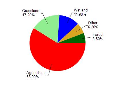
Gill Creek is located in the East Branch Rock River watershed which is 198.99 mi². Land use in the watershed is primarily agricultural (58.90%), grassland (17.20%) and a mix of wetland (11.90%) and other uses (12.00%). This watershed has 306.48 stream miles, 292.02 lake acres and 16,059.62 wetland acres.
Nonpoint Source Characteristics
This watershed is ranked High for runoff impacts on streams, High for runoff impacts on lakes and High for runoff impacts on groundwater and therefore has an overall rank of High. This value can be used in ranking the watershed or individual waterbodies for grant funding under state and county programs.However, all waters are affected by diffuse pollutant sources regardless of initial water quality. Applications for specific runoff projects under state or county grant programs may be pursued. For more information, go to surface water program grants.