Dane
Yes
Yes
No
Fish and Aquatic Life
Overview
Rutland Branch This small spring-fed stream, which joins with the Oregon Branch to form Badfish Creek, supports trout and is designated an Exceptional Resource Water. The stream has a sand bottom with muck in the lower reaches and gravel in the upper reaches. While some channelization has occurred, the stream appears to be restoring itself. WDNR has acquired property adjacent the stream and is interested in at least two additional acquisitions. One acquisition would protect the large spring at the creek's headwaters and the other acquisition would protect five major and numerous minor springs that feed that creek and support the trout. Rutland Branch's water quality threat from agricultural polluted runoff is surpassed only by the threat from development in the watershed and ponding of the springs. Some headwater springs have been already been tapped for ponds. WDNR will continue to pursue acquisition and/or other protection for these important sources of the stream's good to excellent water quality. WDNR South Central Region staff recommend that no new permits be issued that would affect this important spring system.
The last biotic index monitoring, conducted in 1989 by MMSD, indicated fairly poor water quality with significant organic pollution (index of 6.76). This represented a decrease in water quality from the previous year's monitoring, despite state ownership of the adjacent land. Continued development pressures and cropland erosion could have been the cause for this result. Fish tissue monitoring for PCBs and pesticides in whole carp, and brown trout fillets was conducted during the summer of 1990. A habitat evaluation rating conducted in May, 1996 where County Trunk a crosses the stream provided a good rating. At that site visit blue herons, spring peepers, and brown trout were observed (Fix).
Date 2002
Author Aquatic Biologist
Historical Description
Rutland Branch (Anthony Branch) -T5N, RI0E, Sec. 16, Surface acres = 1.5, Length = 2 miles, Stream order = I, Gradient = 25.6 ft/mile, Base discharge = 6.8 cfs.
Rutland Branch is a small, spring-fed tributary which joins the Oregon Branch to form Badfish Creek. It drains about 6 square miles of wet meadow, pasture, and cropland. Rutland Branch was heavily ditched in the 1940's and 1950's but has since recovered from this disturbance (Dane Cty. Reg. Pl, Comm. 1979a). A modest wild brown trout population now nhabits the creek. Its substrate is mostly sand and gravel with little silt. Although it receives no municipal or industrial discharge, the creek is subject to agricultural runoff problems. Conductivity is somewhat higher than normal for Dane County streams. Access is available at Hwy. A. Fish species: brook lamprey, rainbow and brown trout, central mudminnow, hornyhead chub, fathead minnow, creek chub, white sucker, brook stickleback, johnny darter, and mottled sculpin.
From: Day, Elizabeth A.; Grzebieniak, Gayle P.; Osterby, Kurt M.; and Brynildson, Clifford L., 1985. Lake and Stream Classification Project. Surface Water Resources of Dane County, Wisconsin Department of Natural Resources, Madison, WI.
Date 1985
Author Surface Water Inventory Of Wisconsin
General Condition
Rutland Branch (Anthony Branch) was assessed during the 2018 listing cycle; new temperature sample data were clearly below the 2018 WisCALM listing thresholds for the Fish and Aquatic Life use. This water was meeting this designated use and was not considered impaired.
Date 2017
Author Ashley Beranek
Condition
Wisconsin has over 84,000 miles of streams, 15,000 lakes and milllions of acres of wetlands. Assessing the condition of this vast amount of water is challenging. The state's water monitoring program uses a media-based, cross-program approach to analyze water condition. An updated monitoring strategy (2015-2020) is now available. Compliance with Clean Water Act fishable, swimmable standards are located in the Executive Summary of Water Condition in 2018. See also the 'monitoring and projects' tab.
Reports
Management Goals
Wisconsin's Water Quality Standards provide qualitative and quantitative goals for waters that are protective of Fishable, Swimmable conditions [Learn more]. Waters that do not meet water quality standards are considered impaired and restoration actions are planned and carried out until the water is once again fishable and swimmable
Management goals can include creation or implementation of a Total Maximum Daily Load analysis, a Nine Key Element Plan, or other restoration work, education and outreach and more. If specific recommendations exist for this water, they will be displayed below online.
Monitoring
Monitoring the condition of a river, stream, or lake includes gathering physical, chemical, biological, and habitat data. Comprehensive studies often gather all these parameters in great detail, while lighter assessment events will involve sampling physical, chemical and biological data such as macroinvertebrates. Aquatic macroinvertebrates and fish communities integrate watershed or catchment condition, providing great insight into overall ecosystem health. Chemical and habitat parameters tell researchers more about human induced problems including contaminated runoff, point source dischargers, or habitat issues that foster or limit the potential of aquatic communities to thrive in a given area. Wisconsin's Water Monitoring Strategy was recenty updated.
Grants and Management Projects
| Project Name (Click for Details) | Year Started |
|---|
|
|
Monitoring Projects
| WBIC | Official Waterbody Name | Station ID | Station Name | Earliest Fieldwork Date | Latest Fieldwork Date | View Station | View Data |
|---|
| 801100 | Unnamed | 10054721 | Rutland Branch - Headwater Spring to County Highway A | 8/26/2020 | 8/26/2020 | Map | Data |
| 801000 | Rutland Br | 10013297 | Rutland Branch (Anthony) 1 | | | Map | Data |
| 801000 | Rutland Br | 10012037 | Rutland Br - Upstream Of Cty Rd. A | 5/28/2014 | 9/29/2025 | Map | Data |
| 801000 | Rutland Br | 10054721 | Rutland Branch - Headwater Spring to County Highway A | 8/26/2020 | 8/26/2020 | Map | Data |
| 801000 | Rutland Br | 10013298 | Rutland Branch (Anthony) 2 | | | Map | Data |
| 801000 | Rutland Br | 10056752 | Anthony Br - Wildlife Area Parking Lot | | | Map | Data |
|
Watershed Characteristics
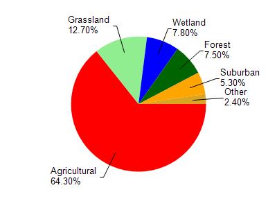
Rutland Br is located in the Badfish Creek watershed which is 84.21 mi². Land use in the watershed is primarily agricultural (64.30%), grassland (12.70%) and a mix of wetland (7.80%) and other uses (15.20%). This watershed has 78.94 stream miles, 217.98 lake acres and 3,799.54 wetland acres.
Nonpoint Source Characteristics
This watershed is ranked Medium for runoff impacts on streams, Not Ranked for runoff impacts on lakes and High for runoff impacts on groundwater and therefore has an overall rank of High. This value can be used in ranking the watershed or individual waterbodies for grant funding under state and county programs.However, all waters are affected by diffuse pollutant sources regardless of initial water quality. Applications for specific runoff projects under state or county grant programs may be pursued. For more information, go to surface water program grants.