Marathon
No
No
Yes
Fish and Aquatic Life
Overview
Fenwood Creek is a one and a half-mile-long tributary to the Wisconsin River that enters at the location of an unnamed bay. The bay was last monitored in 2011, but its general condition is unknown.
Date 2011
Author Aquatic Biologist
Historical Description
Fenwood Creek - A 1977 wastewater receiving stream classification indicated Fenwood Creek appeared to be affected by agricultural NPS run-off. Two biotic index samples collected in 1978 showed fair water quality.
Kreitlow, James D. 1991. Upper Wisconsin River Central Sub-Basin Water Quality Management Plan. PUBL-WR-287-91-REV. Wisconsin Department of Natural Resources, Madison, WI.
Date 1991
Author Aquatic Biologist
Impaired Waters
Fenwood Creek was recently evaluated during the ten-year period of 2009 through 2018 for results that were reported to the USEPA for the 2020 Clean Water Act condition report. The waterbody is considered impaired, or in poor condition for designated uses which include the quality of fish and aquatic life, recreational use, and public health and welfare (fish consumption and related). Pollutants or problems encountered during sampling (impairments) are determined based on water quality standards outlined in Wisconsin 2020 Consolidated Assessment and Listing Methodology (WisCALM). Assessment results show water conditions that are potentially harmful for Aquatic Life use due to values for total phosphorus that fall into the range expected for an aquatic community in poor health, therefore this water is listed as impaired.
Fenwood Creek (mile 0-1.5): Recent assessments show this segment is impaired by total phosphorus levels.
Fenwood Creek (mile 1.5-17): Assessment results during the 2020 listing cycle show overwhelmingly high total phosphorus levels based on 2020 WisCALM listing critieria. Based on the most updated information, this water is proposed for the impaired waters list.
Date 2019
Author Ashley Beranek
Impaired Waters
Fenwood Creek (1428700) from Rocky Run confluence to its headwaters was placed on the impaired waters list for total phosphorus in 2012. The creek from it's mouth to Rock Run confluence was placed on the impaired waters list for total phosphorus in 2014. The 2016 assessments showed continued impairment by phosphorus; total phosphorus sample data exceed 2016 WisCALM listing criteria for the Fish and Aquatic Life use, however, no biological data (i.e. no macroinvertebrate or fish Index of Biotic Integrity (IBI) scores) were available to assess biological impairment. This water was also assessed for chlorides and sample data did not exceed 2016 WisCALM chronic and acute listing criteria for the Fish and Aquatic Life use. Based on the most updated information, no change in existing impaired waters listing is needed.
Date 2015
Author Aaron Larson
Condition
Wisconsin has over 84,000 miles of streams, 15,000 lakes and milllions of acres of wetlands. Assessing the condition of this vast amount of water is challenging. The state's water monitoring program uses a media-based, cross-program approach to analyze water condition. An updated monitoring strategy (2015-2020) is now available. Compliance with Clean Water Act fishable, swimmable standards are located in the Executive Summary of Water Condition in 2018. See also the 'monitoring and projects' tab.
Reports
Recommendations
Monitor or Propose 303(d) Listing
Fenwood Creek -1428700. Nutrient and sediment loading from the watershed causes severe summer algae blooms and contributes to low dissolved oxygen levels in the winter. WCR has scheduled TMDL monitoring for the flowage to begin in FY10 to address the impairment.
Monitor Targeted Watershed Area (TWA)
The purpose of this study is to collect baseline macroinvertebrate samples to assess biological conditions for 9 Key element plan and future implementation of BMPs in watershed. A final TWA/WQ Plan was produced for this effort.
Nine Key Element Plan
Fenwood Creek Nine Key Element Plan, Marathon County - The Fenwood Creek Nine Key Element Plan in Marathon County covers 25187 acres.Fenwood Creek Watershed Management Plan The Fenwood Creek watershed drains approximately 39 square miles (24,958 acres) of land into the Big Eau Pleine (BEP) reservoir. Fenwood Creek represents one of three (3) major surface water tributaries that empty into the BEP reservoir which immediately flows into Lake DuBay, both flowages of the Upper Wisconsin River Central Sub Basin. The following plan will provide an overview of the physical characteristics of the Fenwood Creek watershed including land use and land management. The plan will also summarize the several environmental studies and programs that increased the understanding of the causes of water quality degradation, past conservation initiatives and investments aimed at reducing agricultural runoff, and program outcomes.
Management Goals
Wisconsin's Water Quality Standards provide qualitative and quantitative goals for waters that are protective of Fishable, Swimmable conditions [Learn more]. Waters that do not meet water quality standards are considered impaired and restoration actions are planned and carried out until the water is once again fishable and swimmable
Management goals can include creation or implementation of a Total Maximum Daily Load analysis, a Nine Key Element Plan, or other restoration work, education and outreach and more. If specific recommendations exist for this water, they will be displayed below online.
Monitoring
Monitoring the condition of a river, stream, or lake includes gathering physical, chemical, biological, and habitat data. Comprehensive studies often gather all these parameters in great detail, while lighter assessment events will involve sampling physical, chemical and biological data such as macroinvertebrates. Aquatic macroinvertebrates and fish communities integrate watershed or catchment condition, providing great insight into overall ecosystem health. Chemical and habitat parameters tell researchers more about human induced problems including contaminated runoff, point source dischargers, or habitat issues that foster or limit the potential of aquatic communities to thrive in a given area. Wisconsin's Water Monitoring Strategy was recenty updated.
Grants and Management Projects
Monitoring Projects
| WBIC | Official Waterbody Name | Station ID | Station Name | Earliest Fieldwork Date | Latest Fieldwork Date | View Station | View Data |
|---|
| 1428700 | Fenwood Creek | 10016149 | Fenwood Crk - App 150 Ft Abv Sth 153 | 9/25/1990 | 9/21/2023 | Map | Data |
| 1428700 | Fenwood Creek | 373121 | Fenwood Creek - Rocky Run Creek | | | Map | Data |
| 1428700 | Fenwood Creek | 373366 | Fenwood Creek at Hwy 153 | 11/13/1973 | 6/22/2021 | Map | Data |
| 1428700 | Fenwood Creek | 10016124 | Fenwood Creek - Above Bridge On 153 | 5/1/1979 | 5/14/1990 | Map | Data |
|
Watershed Characteristics
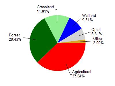
Fenwood Creek is located in the Lower Big Eau Pleine River watershed which is 138.59 mi². Land use in the watershed is primarily agricultural (37.80%), forest (29.40%) and a mix of grassland (14.80%) and other uses (17.90%). This watershed has stream miles, lake acres and 3,698.60 wetland acres.
Nonpoint Source Characteristics
This watershed is ranked High for runoff impacts on streams, High for runoff impacts on lakes and High for runoff impacts on groundwater and therefore has an overall rank of High. This value can be used in ranking the watershed or individual waterbodies for grant funding under state and county programs.However, all waters are affected by diffuse pollutant sources regardless of initial water quality. Applications for specific runoff projects under state or county grant programs may be pursued. For more information, go to surface water program grants.