Crawford
Yes
No
No
Fish and Aquatic Life
Overview
Halls Branch, located in central Crawford County, flows in an easterly direction for five miles before reaching the Kickapoo River near Bell Center. This stream has a gradient of 43 feet per mile and drains wooded hillsides and agricultural valleys. Halls Creek is a Class III trout stream for two miles from its mouth up to Zintz Road and Class II upstream of Zintz Road for three miles.
The most recent survey, conducted in 1998, documented a cool, clear stream with a bottom comprised mainly of sand with a balance of silt, gravel, cobble, and boulders. Adequate instream cover was available for the brook and brown trout found in the stream. Numerous forage fish species were also documented. Unrestricted cattle access to the steep banks of Halls Branch was also documented as a pervasive source of sediment. Halls Branch would benefit from the purchase of streambank easements from willing sellers and the restoration of in-stream habitat. WDNR records indicate Halls Branch has been stocked with brown trout since 1961, while brook trout have only been stocked intermittently since 1996. Access to Halls Branch is from four road crossings and WDNR owned land. A state threatened species has been found in this creek.
Fishery Survey 1967 - Documented a brown trout fishery that justified the classifications of Cold II on the upper 3.0 miles and Cold III on the lower 2.0 miles.
Fishery Survey 1998 - Documented very few brown trout throughout the entire stream. This survey indicated that the upper 3.0 miles of Halls Branch Creek was not meeting its codified use of Cold II.
From: Ripp, Coreen, Koperski, Cindy and Folstad, Jason. 2002. The State of the Lower Wisconsin River Basin. PUBL WT-559-2002. Wisconsin Department of Natural Resources, Madison, WI.
Date 2002
Author Cynthia Koperski
Historical Description
This stream has been severely affected by seasonal flooding, streambank erosion and stream channelization. These impacts severely limit the potential to improve the trout fishery in this stream. This stream has been chosen by the village of Seneca wastewater treatment plant (WWTP) facilities plan as a potential discharge site.
Date 1994
Author Aquatic Biologist
Condition
Wisconsin has over 84,000 miles of streams, 15,000 lakes and milllions of acres of wetlands. Assessing the condition of this vast amount of water is challenging. The state's water monitoring program uses a media-based, cross-program approach to analyze water condition. An updated monitoring strategy (2015-2020) is now available. Compliance with Clean Water Act fishable, swimmable standards are located in the Executive Summary of Water Condition in 2018. See also the 'monitoring and projects' tab.
Reports
Recommendations
Citizen-Based Stream Monitoring
Collect chemical, physical, and/or biological water quality data to assess the current overall stream health. The data can inform management decisions and may be used to identify impaired waters for biennial lists.
Management Goals
Wisconsin's Water Quality Standards provide qualitative and quantitative goals for waters that are protective of Fishable, Swimmable conditions [Learn more]. Waters that do not meet water quality standards are considered impaired and restoration actions are planned and carried out until the water is once again fishable and swimmable
Management goals can include creation or implementation of a Total Maximum Daily Load analysis, a Nine Key Element Plan, or other restoration work, education and outreach and more. If specific recommendations exist for this water, they will be displayed below online.
Monitoring
Monitoring the condition of a river, stream, or lake includes gathering physical, chemical, biological, and habitat data. Comprehensive studies often gather all these parameters in great detail, while lighter assessment events will involve sampling physical, chemical and biological data such as macroinvertebrates. Aquatic macroinvertebrates and fish communities integrate watershed or catchment condition, providing great insight into overall ecosystem health. Chemical and habitat parameters tell researchers more about human induced problems including contaminated runoff, point source dischargers, or habitat issues that foster or limit the potential of aquatic communities to thrive in a given area. Wisconsin's Water Monitoring Strategy was recenty updated.
Grants and Management Projects
Monitoring Projects
| WBIC | Official Waterbody Name | Station ID | Station Name | Earliest Fieldwork Date | Latest Fieldwork Date | View Station | View Data |
|---|
| 1184300 | Halls Br | 10013661 | Halls Branch Station 2 - 1998 80 Ft. Upstream Of Bridge On Zintz Rd. | | | Map | Data |
| 1184300 | Halls Br | 10013650 | Halls Branch - Zintz Rd. Bridge | 5/14/1997 | 6/15/2017 | Map | Data |
| 1184300 | Halls Br | 10013649 | Halls Branch Station 2 - 1961 N-S Centerline Of Section 4 | | | Map | Data |
| 1184300 | Halls Br | 10012461 | Halls Branch 100 Yds Upstream From Zintz Rd. | 9/7/1998 | 10/18/2023 | Map | Data |
| 1184300 | Halls Br | 10013653 | Halls Branch Station #1 - 1967 Little Haney Rd. Bridge | 10/15/2012 | 10/20/2016 | Map | Data |
| 1184300 | Halls Br | 10022293 | Halls Branch Cr. St. 2 - 125m Downstream Of Equipment Crossing State Lands | 1/1/2015 | 1/1/2015 | Map | Data |
| 1184300 | Halls Br | 10013507 | Halls Branch St. 1 - 180 Meters Downstream Zintz Road | | | Map | Data |
| 1184300 | Halls Br | 10013660 | Halls Branch Station 1 - 1998 100 Feet Upstream Of Bridge On Little Haney Rd. | | | Map | Data |
| 1184300 | Halls Br | 10022294 | Halls Branch Cr. St. 3 - 135m Downstream Of Zintz Rd. Bridge | 1/1/2015 | 1/1/2015 | Map | Data |
| 1184300 | Halls Br | 10013656 | Halls Branch Station 2 - 1967 8000 Ft Upstream Of Little Haney Rd. Bridge | | | Map | Data |
|
Watershed Characteristics
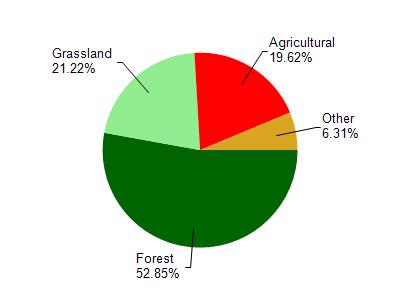
Halls Br is located in the Lower Kickapoo River watershed which is 150.21 mi². Land use in the watershed is primarily forest (52.80%), grassland (21.20%) and a mix of agricultural (19.60%) and other uses (6.30%). This watershed has 383.20 stream miles, 387.48 lake acres and 3,662.70 wetland acres.
Nonpoint Source Characteristics
This watershed is ranked High for runoff impacts on streams, Not Ranked for runoff impacts on lakes and High for runoff impacts on groundwater and therefore has an overall rank of High. This value can be used in ranking the watershed or individual waterbodies for grant funding under state and county programs.This water is ranked Medium Stream for individual Rivers based on runoff problems and the likelihood of success from project implementation.