Vernon
Yes
No
No
Fish and Aquatic Life
Overview
The West Fork of the Kickapoo River, located in central Vernon County, flows in a
southeasterly direction for 24 miles before reaching the Kickapoo River. This river has a
gradient of 11 feet per mile and drains forested hillsides and agricultural valleys. A wet flood
control structure is located on the upper end of this river creating Jersey Valley Lake. The
West Fork of the Kickapoo River is a Class II trout stream from its mouth upstream 15.8
miles to the STH 82 bridge and Class I upstream from this bridge for 8.2 miles.
The most recent survey, conducted in 2000, documented healthy brook trout and brown trout
populations as well as a diverse forage fishery. The stream bottom was dominated by cobble
and gravel. In order of abundance, in-stream cover consisted of LUNKER structures, woody
debris, boulders, undercut banks, and boulders. Since the 2000 survey was conducted
upstream of STH 82, an updated fish and habitat survey should be conducted of the river
downstream of STH 82. The West Fork of the Kickapoo River would benefit from the
purchase of streambank easements from willing sellers and the restoration of in-stream
habitat. WDNR records indicate that the West Fork of the Kickapoo River has been stocked
with brown trout consistently from 1960 to 1998. Wild brook trout have been stocked yearly
since 1999. Access to the West Fork of the Kickapoo River is from 14 road crossings, WDNR
owned land and the Vernon County Jersey Valley Park. A rare aquatic species has been found
in this creek.
From: Ripp, Coreen, Koperski, Cindy and Folstad, Jason. 2002. The State of the Lower Wisconsin River Basin.
PUBL WT-559-2002. Wisconsin Department of Natural Resources, Madison, WI.
Date 2002
Author Cynthia Koperski
Historical Description
The West Fork Kickapoo River has the potential to improve from a Class III to a Class II trout stream if nonpoint source water pollution is controlled. A portion of the stream is managed as a catch-and-release, trophy trout stream.
Date 1994
Author Surface Water Inventory Of Wisconsin
Historical Description
Kickapoo River, West Fork, T11N, R3W, Section 4. Surface Acres = 78.5, Miles = 24.0, Gradient = 10.8 feet per mile.
Flowing in a southerly direction, this clear, hard water stream joins the Kickapoo River just north of Readstown. Locally, that portion of the West Fork above the junction of Knapp Creek is called Jersey Valley Creek. From State Trunk Highway 82 crossing upstream, the stream is Class III brown trout water. That portion of stream between 82 and County Trunk Highway "P" is also managed for smallmouth bass. Northern pike, green sunfish and numerous species of minnows and other forage species are also present. Sand is the dominant bottom type, with some rubble and small amounts of bedrock, silt and gravel.
Jersey Valley Lake is located on the stream. A quasi-public park, several road crossings, Jersey Valley Lake and park, and the Kickapoo River all provide access. Beaver are present and muskrat are significant. Teal, mallards, and wood ducks nest along the stream, and migrant puddle and diving ducks use the water.
From: Klick, Thomas A. and Threinen, C.W., 1973. Lake and Stream Classification Project. Surface Water Resources of Vernon County, Wisconsin Department of Natural Resources, Madison, WI.
Date 1973
Author Surface Water Inventory Of Wisconsin
Impaired Waters
The West Fork Kickapoo River (Mouth to Highway 82, miles 0 - 10.3) was evaluated in the 2022 cycle: phosphorus levels were above listing thresholds as outlined in 2022 WisCALM. This stream was added to the 2022 Impaired Waters List.
Date 2022
Author Ashley Beranek
Condition
Wisconsin has over 84,000 miles of streams, 15,000 lakes and milllions of acres of wetlands. Assessing the condition of this vast amount of water is challenging. The state's water monitoring program uses a media-based, cross-program approach to analyze water condition. An updated monitoring strategy (2015-2020) is now available. Compliance with Clean Water Act fishable, swimmable standards are located in the Executive Summary of Water Condition in 2018. See also the 'monitoring and projects' tab.
Reports
Recommendations
Citizen-Based Stream Monitoring
Collect chemical, physical, and/or biological water quality data to assess the current overall stream health. The data can inform management decisions and may be used to identify impaired waters for biennial lists.
Citizen-Based Stream Monitoring
Collect chemical, physical, and/or biological water quality data to assess the current overall stream health. The data can inform management decisions and may be used to identify impaired waters for biennial lists.
Citizen-Based Stream Monitoring
Collect chemical, physical, and/or biological water quality data to assess the current overall stream health. The data can inform management decisions and may be used to identify impaired waters for biennial lists.
Citizen-Based Stream Monitoring
Collect chemical, physical, and/or biological water quality data to assess the current overall stream health. The data can inform management decisions and may be used to identify impaired waters for biennial lists.
Watershed Mapping or Assessment
The Valley Stewardship Network is sponsoring a project to initiate two farmer-led watershed councils to identify and cooperatively solve nutrient runoff issues with conservation practices fundable though the Mississippi River Basin Healthy Watersheds Initiative (MRBI). Project activities and deliverables include: 1) mailings, meetings, and events to identify leaders and goals within Tainter and Knapp Creek watersheds, 2) establishment and facilitation of councils, 3) sociological surveys, 4) outreach and training re: MRBI conservation practices including water quality sampling, 5) data summarization with annual reports and mapping, 6) development of outreach materials for field day events, 7) pre and post-practice water quality samping and data entry (SWIMS), and 8) final report. This scope summarizes the project detail provided in the application and does not negate tasks/deliverables described therein. Data, records, and reports, including GIS-based maps and digital images must be submitted to the Department in a format specified by the regional Lake Planner.
Rivers Management Grant
The project is located on the West Fork of the Kickapoo River. Proposing to stabilize over 2000 feet of streambank and place 24 LUNKERS(trout habitat overhead cover). Between the bank stabilization sites we propose to shape and stablize additional feet of bank and place additional in water structures for trout.
Control Streambank Erosion
The project is located on the West Fork of the Kickapoo River. Proposing to stabilize over 2000 feet of streambank and place 24 LUNKERS(trout habitat overhead cover). Between the bank stabilization sites we propose to shape and stablize additional feet of bank and place additional in water structures for trout.
Protect Riparian or Shorelands
stabilize over 2000 feet of streambank and place 24 LUNKERS(trout habitat overhead cover). Between the bank stabilization sites we propose to shape and stabilize additional feet of bank and place additional in water structures for trout
Restore Wetlands
Restore Wetlands
Restore Wetlands
Restore Wetlands
Monitor Water Quality or Sediment
Our analysis shows a median of 73 ug/l. Please provide the data used for analysis.
The 924 ug/L value seems anomalous and without it the median is 74.6 ug/L and lower confidence value is 73.6 ug/L. I recommend we don't list this water right now. More monitoring recommended.
Management Goals
Wisconsin's Water Quality Standards provide qualitative and quantitative goals for waters that are protective of Fishable, Swimmable conditions [Learn more]. Waters that do not meet water quality standards are considered impaired and restoration actions are planned and carried out until the water is once again fishable and swimmable
Management goals can include creation or implementation of a Total Maximum Daily Load analysis, a Nine Key Element Plan, or other restoration work, education and outreach and more. If specific recommendations exist for this water, they will be displayed below online.
Monitoring
Monitoring the condition of a river, stream, or lake includes gathering physical, chemical, biological, and habitat data. Comprehensive studies often gather all these parameters in great detail, while lighter assessment events will involve sampling physical, chemical and biological data such as macroinvertebrates. Aquatic macroinvertebrates and fish communities integrate watershed or catchment condition, providing great insight into overall ecosystem health. Chemical and habitat parameters tell researchers more about human induced problems including contaminated runoff, point source dischargers, or habitat issues that foster or limit the potential of aquatic communities to thrive in a given area. Wisconsin's Water Monitoring Strategy was recenty updated.
Grants and Management Projects
Monitoring Projects
| WBIC | Official Waterbody Name | Station ID | Station Name | Earliest Fieldwork Date | Latest Fieldwork Date | View Station | View Data |
|---|
| 1187900 | West Fork Kickapoo River | 10013077 | West Fork Kickapoo St. 2-05 Snowmobile Bridge Livingwaters Bible Camp | 4/14/2005 | 4/14/2005 | Map | Data |
| 1187900 | West Fork Kickapoo River | 10009120 | West Fork Kickapoo River #3- 1350 Feet Below Cty S Bridge Fence Line South End Of Park | 1/1/2015 | 1/1/2015 | Map | Data |
| 1187900 | West Fork Kickapoo River | 10013076 | West Fork Kickapoo River St. 1-05 Bridge On Cty P | 5/13/1980 | 8/15/2020 | Map | Data |
| 1187900 | West Fork Kickapoo River | 10013773 | West Fork Kickapoo River Station 7 - 500 Ft. Upstream Of Cth P Bridge | | | Map | Data |
| 1187900 | West Fork Kickapoo River | 10029589 | West Fork Kickapoo River St. 4 - 2008 (Serendipity Golf Course) | 1/1/2015 | 1/1/2015 | Map | Data |
| 1187900 | West Fork Kickapoo River | 10041633 | West Fork Kickapoo River at Stream Crossing on Wahl's Land | 1/1/2015 | 1/1/2015 | Map | Data |
| 1187900 | West Fork Kickapoo River | 633164 | Kickapoo River West Fork - Sportsmans Club | 10/7/1998 | 6/29/2003 | Map | Data |
| 1187900 | West Fork Kickapoo River | 633060 | Kickapoo River West Fork - Ne1/4ofsw1/4 Sec. 30 | | | Map | Data |
| 1187900 | West Fork Kickapoo River | 10030275 | West Fork Kickapoo River 125 yds downstream of CTH P | 5/16/2009 | 10/18/2023 | Map | Data |
| 1187900 | West Fork Kickapoo River | 10013772 | West Fork Kickapoo River Station 6 - Bridge On Cth S In Section 6 | 1/1/2015 | 8/15/2020 | Map | Data |
| 1187900 | West Fork Kickapoo River | 10009124 | West Fork Kickapoo River #2- 1000 Feet Below River Rd. Bridge | | | Map | Data |
| 1187900 | West Fork Kickapoo River | 10009121 | West Fork Kickapoo River - Smart Hollow Rd. Bridge | 9/12/2016 | 6/27/2020 | Map | Data |
| 1187900 | West Fork Kickapoo River | 10009123 | West Fork Kickapoo River #1- Hwy 82 Bridge | 5/13/1980 | 6/27/2020 | Map | Data |
| 1187900 | West Fork Kickapoo River | 633199 | West Fork Kickapoo River at Knapp Valley Rd | 5/2/2005 | 8/15/2020 | Map | Data |
| 1187900 | West Fork Kickapoo River | 10009122 | West Fork Kickapoo River #6- 787 Feet Downstream From Cty P Bridge Where Feeder Stream Joins West Fo | | | Map | Data |
| 1187900 | West Fork Kickapoo River | 10033415 | West Fork Kickapoo River 100 yd downstream of CTH S bridge in Avalanche | 4/16/2007 | 9/30/2008 | Map | Data |
| 1187900 | West Fork Kickapoo River | 633185 | Kickapoo River West Fork - Below Left Embankment Seep Tributary | 4/26/2005 | 5/2/2005 | Map | Data |
| 1187900 | West Fork Kickapoo River | 10022630 | West Fork Kickapoo River - Bloomingdale Rd. | 6/28/2012 | 6/27/2020 | Map | Data |
| 1187900 | West Fork Kickapoo River | 10013771 | West Fork Kickapoo River - CTH Y (Near S and Avalanche Rd) | 7/7/2011 | 10/18/2023 | Map | Data |
| 1187900 | West Fork Kickapoo River | 633198 | West Fork Kickapoo River at Living Waters Bible Camp | 5/2/2005 | 5/2/2005 | Map | Data |
| 1187900 | West Fork Kickapoo River | 633057 | West Fork Kickapoo River - Hwy 82 Bridge | 10/29/1980 | 9/14/2016 | Map | Data |
| 1187900 | West Fork Kickapoo River | 633076 | Kickapoo River W Fork - Wesby Road Near Bloomingdale | 8/7/1991 | 7/7/1992 | Map | Data |
| 1187900 | West Fork Kickapoo River | 10033414 | West Fork Kickapoo River 0.9 mi. N of STH 82 on CTH S downstream of bridge | 4/7/2002 | 9/30/2008 | Map | Data |
| 1187900 | West Fork Kickapoo River | 10029590 | W Fork Kickapoo R St. 9 - 2008 (Living Waters Bible Camp) | 1/1/2015 | 1/1/2015 | Map | Data |
| 1187900 | West Fork Kickapoo River | 633184 | Kickapoo River West Fork at Jersey Valley Outfall | 4/26/2005 | 5/2/2005 | Map | Data |
| 1187900 | West Fork Kickapoo River | 10044920 | West Fork Kickapoo River at River Road Bridge | 1/1/2015 | 6/27/2020 | Map | Data |
| 1187900 | West Fork Kickapoo River | 10052398 | West Fork Kickapoo River 700 m above Smart Hollow Rd. | | | Map | Data |
| 1187900 | West Fork Kickapoo River | 10009125 | West Fork Kickapoo River #5- 1650 Feet Below Cth S Bridge | 1/1/2015 | 1/1/2015 | Map | Data |
| 1187900 | West Fork Kickapoo River | 10013770 | West Fork Kickapoo River - CTH S Bridge | 9/10/1998 | 6/27/2020 | Map | Data |
| 1187900 | West Fork Kickapoo River | 10030274 | West Fork Kickapoo River 100 yds downstream of CTH S | 5/9/2006 | 4/10/2021 | Map | Data |
|
Watershed Characteristics
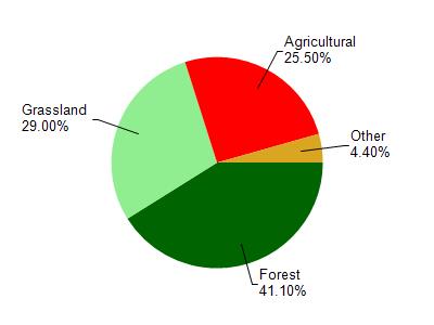
West Fork Kickapoo River is located in the West Fork Kickapoo River watershed which is 118.04 mi². Land use in the watershed is primarily forest (41.10%), grassland (29%) and a mix of agricultural (25.50%) and other uses (4.40%). This watershed has 283.75 stream miles, 49.18 lake acres and 672.36 wetland acres.
Nonpoint Source Characteristics
This watershed is ranked High for runoff impacts on streams, Not Ranked for runoff impacts on lakes and High for runoff impacts on groundwater and therefore has an overall rank of High. This value can be used in ranking the watershed or individual waterbodies for grant funding under state and county programs.However, all waters are affected by diffuse pollutant sources regardless of initial water quality. Applications for specific runoff projects under state or county grant programs may be pursued. For more information, go to surface water program grants.