Vernon
Yes
No
No
Fish and Aquatic Life
Overview
Weister Creek, located in central Vernon County, flows in a southeasterly direction for 7.8
miles before reaching the Kickapoo River north of La Farge. This stream has a gradient of 39
feet per mile and drains forested hillsides, agricultural valleys and ridgetops as well as a
portion of the Kickapoo Valley Reserve. Wetlands surround the lower segment of Weister
Creek within the Reserve. Weister Creek is a Class III trout stream for its entire length.
The most recent survey, conducted in 1990, documented brown trout and numerous forage
fish species. The stream bottom was dominated by sand and gravel. In-stream cover consisted
of woody debris and undercut banks. Weister Creek should be resurveyed after conclusion of
the Middle Kickapoo River Priority Watershed Project in 2004. WDNR records indicate that Weister Creek has been regularly stocked with brown trout since 1960. Access to Weister
Creek is from six road crossings and the Kickapoo Valley Reserve.
From: Ripp, Coreen, Koperski, Cindy and Folstad, Jason. 2002. The State of the Lower Wisconsin River Basin.
PUBL WT-559-2002. Wisconsin Department of Natural Resources, Madison, WI.
Date 2002
Author Cynthia Koperski
Historical Description
Weister Creek, T13N, R2W, Section 9. Surface Acres = 9.9, Miles = 7.8, Gradient = 39.3 feet per mile.
This clear, hard water stream flows in a southeasterly direction and is a tributary of the Kickapoo River. It is Class III brown trout water. Scattered open water areas were noted from about one-half mile below Dell downstream during the winter aerial groundwater survey. Sand is the dominant bottom type, but there is considerable gravel, some rubble and silt in nearly equal amounts, and a little boulder. Access is provided by five road crossings. Muskrat are significant and beaver are present. Waterfowl use includes nesting wood ducks and migrant puddle ducks.
From: Klick, Thomas A. and Threinen, C.W., 1973. Lake and Stream Classification Project. Surface Water Resources of Vernon County, Department of Natural Resources, Madison, WI.
Date 1973
Author Surface Water Inventory Of Wisconsin
General Condition
Weister Creek was assessed during the 2018 listing cycle; new biological (fish Index of Biotic Integrity (IBI) scores) sample data were clearly below the 2018 WisCALM listing thresholds for the Fish and Aquatic Life use. This water was meeting this designated use and was not considered impaired.
Date 2017
Author Ashley Beranek
Condition
Wisconsin has over 84,000 miles of streams, 15,000 lakes and milllions of acres of wetlands. Assessing the condition of this vast amount of water is challenging. The state's water monitoring program uses a media-based, cross-program approach to analyze water condition. An updated monitoring strategy (2015-2020) is now available. Compliance with Clean Water Act fishable, swimmable standards are located in the Executive Summary of Water Condition in 2018. See also the 'monitoring and projects' tab.
Reports
Management Goals
Wisconsin's Water Quality Standards provide qualitative and quantitative goals for waters that are protective of Fishable, Swimmable conditions [Learn more]. Waters that do not meet water quality standards are considered impaired and restoration actions are planned and carried out until the water is once again fishable and swimmable
Management goals can include creation or implementation of a Total Maximum Daily Load analysis, a Nine Key Element Plan, or other restoration work, education and outreach and more. If specific recommendations exist for this water, they will be displayed below online.
Monitoring
Monitoring the condition of a river, stream, or lake includes gathering physical, chemical, biological, and habitat data. Comprehensive studies often gather all these parameters in great detail, while lighter assessment events will involve sampling physical, chemical and biological data such as macroinvertebrates. Aquatic macroinvertebrates and fish communities integrate watershed or catchment condition, providing great insight into overall ecosystem health. Chemical and habitat parameters tell researchers more about human induced problems including contaminated runoff, point source dischargers, or habitat issues that foster or limit the potential of aquatic communities to thrive in a given area. Wisconsin's Water Monitoring Strategy was recenty updated.
Grants and Management Projects
Monitoring Projects
| WBIC | Official Waterbody Name | Station ID | Station Name | Earliest Fieldwork Date | Latest Fieldwork Date | View Station | View Data |
|---|
| 1194900 | Weister Creek | 10053397 | Weister Creek 780 M US 24 Valley Road | 11/10/2019 | 11/10/2019 | Map | Data |
| 1194900 | Weister Creek | 10047624 | Weister Creek At 24 Valley Rd. Bridge | 1/1/2015 | 1/1/2015 | Map | Data |
| 1194900 | Weister Creek | 10055415 | Weister Creek off CTH P near confluence with Kickapoo River | | | Map | Data |
| 1194900 | Weister Creek | 633053 | Weister Creek - Nw1/4 Of Sw1/4 Sec 5 | | | Map | Data |
| 1194900 | Weister Creek | 10009921 | Weister Creek - Weister Creek Station 1-2002 Starts At Confluence Of Kickapoo River | 10/20/2016 | 10/8/2024 | Map | Data |
| 5028942 | Unnamed | 10037570 | 24 Valley Creek on 24 Valley Rd betw. CO P & La Flash Rd | 5/17/2012 | 8/22/2012 | Map | Data |
| 1194900 | Weister Creek | 10009923 | Weister Creek - Weister Creek St. 3 - 2002 Dell Rd. Bridge Crossing | 5/14/1980 | 1/1/2015 | Map | Data |
| 1194900 | Weister Creek | 10032375 | Weister Creek - Cary Road | 1/1/2015 | 1/1/2015 | Map | Data |
| 1194900 | Weister Creek | 10033413 | Weister Creek along Wolf Valley Road 400 ft upstream CTH P | 9/3/1998 | 4/29/2008 | Map | Data |
| 1194900 | Weister Creek | 10030019 | Weister Creek upstream of CTH P in S5 | 10/29/2009 | 9/10/2017 | Map | Data |
| 1194900 | Weister Creek | 10009924 | Weister Creek - Weister Creek St. 4-2002 Manke Driveway First Driveway Off Upstream Dell Rd | | | Map | Data |
| 1194900 | Weister Creek | 10009922 | Weister Creek - Weister Creek St. 2-2002 324 Meters Downstream Valley Rd Bridge | 4/20/1990 | 11/10/2019 | Map | Data |
| 1194900 | Weister Creek | 10055287 | Weister Creek at Dell Road | | | Map | Data |
|
Watershed Characteristics
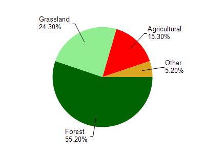
Weister Creek is located in the Middle Kickapoo River watershed which is 246.53 mi². Land use in the watershed is primarily forest (55.20%), grassland (24.30%) and a mix of agricultural (15.30%) and other uses (5.20%). This watershed has 585.18 stream miles, 145.14 lake acres and 3,360.69 wetland acres.
Nonpoint Source Characteristics
This watershed is ranked Not Available for runoff impacts on streams, Not Available for runoff impacts on lakes and High for runoff impacts on groundwater and therefore has an overall rank of High. This value can be used in ranking the watershed or individual waterbodies for grant funding under state and county programs.However, all waters are affected by diffuse pollutant sources regardless of initial water quality. Applications for specific runoff projects under state or county grant programs may be pursued. For more information, go to surface water program grants.