Vernon
No
No
Yes
Fish and Aquatic Life
Overview
Jug Creek, a 3.6 miles long stream located in Vernon County is listed as impaired on the 1998 Wisconsin 303(d). Jug Creek is located in the driftless area of southwestern Wisconsin about 25 miles east of the Mississippi. Jug Creek flows in a westerly direction and spills into the Kickapoo River inside the Army Corps of Engineers land just south of the village of Rockton.
Jug Creek has a high gradient of 71 feet per mile. Land use in the 5.2 square mile Jug Creek Watershed is 27% agricultural, 62% woodland, and 11% grassland, roads, quarries, and wetland. The agricultural land is located either along the stream or on ridge tops; typical of the two-story farming in the coulee area. Jug Creek was listed as a medium priority for TMDL development.
Jug Creek is specifically listed as impaired due to the lack of trout or other sport fish in the stream. Minnows and other species dominate the fish community in Jug Creek. The 1990 fish survey found 14 species of minnow and other forage species, but the species are generally pollution tolerant species. The temperatures of the stream are adequate to support a coldwater fishery. Based on the Hilsenhoff Biotic Index (HBI) of 4.28 indicating slight organic pollution dissolved oxygen is unlikely to be a concern. Water clarity is good.
The stream habitat is rated as good. The stream bottom is generally coarse or fine gravel with some sand.
Near the mouth of Jug Creek the stream bottom is 40% silt. However, at a mid-stream location, only 10% of the stream bottom is covered with silt. The runs and riffle are clean of silt and one pool shows about 0.1 feet of deposited sediment. The typical embeddedness is less than 5%. There is no aquatic vegetation and instream cover is generally scarce and limited to non-woody debris. However, the overall stream habitat shows a tendency to be unstable. This situation compares very closely to the habitat of Reads Creek a similarly sized class I trout stream tributary to the Kickapoo River north of Jug Creek. Reads Creek, however, has more in-stream cover.
Given the high gradient coupled with the unstable habitat and scarce in-stream woody cover, it appears the lack of sport fish is due to the very flashy conditions of the stream. This is likely to include coarse-grained
sediment that is carried (flushed) through the stream during runoff events. At a minimum, the coarse-grained sediment is adding to the instability of the stream banks and may effect the fishery directly. These coarse grained sediments cause abrasion of the fish gills and other physical and biological impacts, forcing fish to
move from Jug Creek. Control of these coarse-grained sediments should result in the return of trout to Jug Creek. Thus, the critical condition for the stream is runoff events and not related to any particular season of the
year. For more information on the topography, soils and geology of Jug Creeks watershed please see Chapter 2 of the Nonpoint Source Control Plan for the Middle Kickapoo Priority Watershed Project.
Date 2002
Author Aquatic Biologist
Historical Description
Jug Creek, T13N, R2W, Section 3. Surface Acres = 2.2, Miles = 3.6, Gradient = 70.9 feet per mile.
A clear, hard water stream that flows in a general northwesterly direction and is a tributary of the Kickapoo River. Minnows and other forage species dominate the fishery. Some of the lower portion of the stream is ditched. Sand dominates as a bottom type. There is also considerable gravel, and some silt and rubble. Two road crossings provide access. Muskrat are significant and wood ducks nest along the stream.
From: Klick, Thomas A. and Threinen, C.W. 1973. Lake and Stream Classification Project. Surface Water Resources of Vernon County, Wisconsin Department of Natural Resources, Madison, WI.
Date 1973
Author Surface Water Inventory Of Wisconsin
General Condition
The stream habitat is rated as good. The stream bottom is generally coarse or fine gravel with some sand. Near the mouth of Jug Creek the stream bottom is 40% silt. However, at a mid-stream location, only 10% of the stream bottom is covered with silt. The runs and riffle are clean of silt and one pool shows about 0.1 feet of deposited sediment. The typical embeddedness is less than 5%. There is no aquatic vegetation and in stream cover is generally scare and limited to non-woody debris. However, the overall stream habitat shows a tendency to be unstable. This situation compares very closely to the habitat of Reads Creek a similarly sized class I trout stream tributary to the Kickapoo River north of Jug Creek. Reads Creek, however, has more in-stream cover.
Given the high gradient coupled with the unstable habitat and scarce in-stream woody cover, it appears the lack of sport fish is due to the very ?flashy? conditions of the stream. This is likely to include coarse-grained sediment that is carried (flushed) through the stream during runoff events. At a minimum, the coarse-grained sediment is adding to the instability of the stream banks and may effect the fishery directly. These coarse grained sediments cause abrasion of the fish gills and other physical and biological impacts, forcing fish to move from Jug Creek. Control of these coarse-grained sediments should result in the return of trout to Jug Creek. Thus, the critical condition for the stream is runoff events and not related to any particular season of the year.
Date 2017
Author Aquatic Biologist
Impaired Waters
Jug Creek, a 3.6 miles long stream located in Vernon County is listed as impaired on the 1998 Wisconsin 303(d). Jug Creek is located in the driftless area of southwestern Wisconsin about 25 miles east of the
Mississippi. Jug Creek flows in a westerly direction and spills into the Kickapoo River inside the Army Corps of Engineers land just south of the village of Rockton. It has a high gradient of 71 feet per mile. Land use in the 5.2 square mile Jug Creek Watershed is 27% agricultural, 62% woodland, and 11% grassland, roads, quarries, and wetland. The agricultural land is located either along the stream or on ridge tops; typical of the �two-story� farming in the coulee area. Jug Creek was listed as a medium priority for TMDL development.
Jug Creek is specifically listed as impaired due to the lack of trout or other sport fish in the stream. Minnows and other species dominate the fish community in Jug Creek. The 1990 fish survey found 14 species of minnow
and other forage species, but the species are generally �pollution tolerant� species. The temperatures of the stream are adequate to support a coldwater fishery. Based on the Hilsenhoff Biotic Index (HBI) of 4.28 �
indicating �slight organic pollution� � dissolved oxygen is unlikely to be a concern. Water clarity is good.
Date
Author Aquatic Resources
Condition
Wisconsin has over 84,000 miles of streams, 15,000 lakes and milllions of acres of wetlands. Assessing the condition of this vast amount of water is challenging. The state's water monitoring program uses a media-based, cross-program approach to analyze water condition. An updated monitoring strategy (2015-2020) is now available. Compliance with Clean Water Act fishable, swimmable standards are located in the Executive Summary of Water Condition in 2018. See also the 'monitoring and projects' tab.
Reports
Recommendations
TMDL Actions in Wisconsin
The Wisconsin Department of Natural Resources (WDNR) developed a sediment TMDL for a segment in the Middle Kickapoo River watershed, Jug Creek, a 3.6 mile segment in Vernon County.
TMDL Development
The Wisconsin Department of Natural Resources (WDNR) developed a sediment TMDL for a segment in the Middle Kickapoo River watershed, Jug Creek, a 3.6 mile segment in Vernon County. The TMDL addresses the sediment impacts and impairments which were identified on the Wisconsin 1998 303(d) list. The segment was ranked as medium priority on the Wisconsin 1998 303(d) list. Jug Creek drains an area about 5.2 square miles. About 27% of the land use in the Jug Creek subwatershed is agriculture, about 62% of the drainage area is woodland, which contributes little sediment to the creeks, and the remaining 11% is classified as other? by WDNR (grassland, roads, quarries, and wetlands). There are no point sources in the Jug Creek subwatershed that discharge sediments. Non-point sources are identified in the Nonpoint Source Control Plan for the Middle Kickapoo River Priority Watershed Project (Watershed Plan), Chapter 2. The Watershed Plan is an attachment to the TMDL. Nonpoint sources identified in the Watershed Plan as contributing to the impairments include agricultural field run-off and streambank erosion. The TMDL identifies the existing annual sediment load of 1326 tons to Jug Creek from the following sources: Uplands 796 tons Gullies 460 tons Stream Banks 97 tons EPA finds that the TMDL document submitted by WDNR satisfies all requirements of this first element.
TMDL (USEPA) Approved
Jug Creek TMDL Approval. EPA finds that the TMDL for Jug Creek satisfies all of the elements of an approvable TMDL. This TMDL addresses 1 TMDL for 1 waterbody with sediment impacts and impairments which were identified on the Wisconsin 1998 303(d) list.
TMDL Implementation
Jug Creek TMDL Implementation addressing 1 TMDL for 1 waterbody with a sediment impairment from the 1998 Wisconsin 303d list. The Wisconsin Department of Natural Resources (WDNR) developed a sediment TMDL for a segment in the Middle Kickapoo River watershed, Jug Creek, a 3.6 mile segment in Vernon County.
Implementation Plan needed.
TMDL Development
The Wisconsin Department of Natural Resources (WDNR) developed a sediment TMDL for a segment in the Middle Kickapoo River watershed, Jug Creek, a 3.6 mile segment in Vernon County. EPA finds that the TMDL for Jug Creek satisfies all of the elements of an approvable TMDL. This document addresses 1 TMDL for 1 waterbody with sediment impairment from the 1998 Wisconsin 303d list.
Management Goals
Wisconsin's Water Quality Standards provide qualitative and quantitative goals for waters that are protective of Fishable, Swimmable conditions [Learn more]. Waters that do not meet water quality standards are considered impaired and restoration actions are planned and carried out until the water is once again fishable and swimmable
Management goals can include creation or implementation of a Total Maximum Daily Load analysis, a Nine Key Element Plan, or other restoration work, education and outreach and more. If specific recommendations exist for this water, they will be displayed below online.
Monitoring
Monitoring the condition of a river, stream, or lake includes gathering physical, chemical, biological, and habitat data. Comprehensive studies often gather all these parameters in great detail, while lighter assessment events will involve sampling physical, chemical and biological data such as macroinvertebrates. Aquatic macroinvertebrates and fish communities integrate watershed or catchment condition, providing great insight into overall ecosystem health. Chemical and habitat parameters tell researchers more about human induced problems including contaminated runoff, point source dischargers, or habitat issues that foster or limit the potential of aquatic communities to thrive in a given area. Wisconsin's Water Monitoring Strategy was recenty updated.
Grants and Management Projects
Monitoring Projects
| WBIC | Official Waterbody Name | Station ID | Station Name | Earliest Fieldwork Date | Latest Fieldwork Date | View Station | View Data |
|---|
| 1195500 | Jug Creek | 10011084 | Jug Creek Station #1 Bridge On South Jug Creek Rd. | 6/17/1991 | 10/20/2019 | Map | Data |
| 1195500 | Jug Creek | 10011085 | Jug Creek Station #2 Bridge On Compton Rd. | 5/10/2010 | 1/1/2015 | Map | Data |
| 1195500 | Jug Creek | 633067 | Jug Creek - Unnamed Rd Off Jug Creek | | | Map | Data |
|
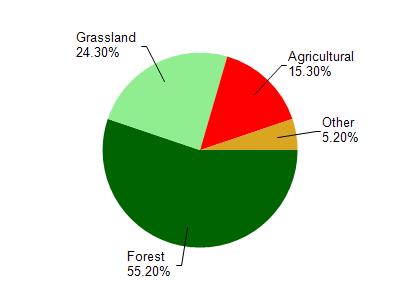
Watershed Characteristics
Jug Creek is located in the Middle Kickapoo River watershed which is 246.53 mi². Land use in the watershed is primarily forest (55.20%), grassland (24.30%) and a mix of agricultural (15.30%) and other uses (5.20%). This watershed has 585.18 stream miles, 145.14 lake acres and 3,360.69 wetland acres.
Nonpoint Source Characteristics
This watershed is ranked Not Available for runoff impacts on streams, Not Available for runoff impacts on lakes and High for runoff impacts on groundwater and therefore has an overall rank of High. This value can be used in ranking the watershed or individual waterbodies for grant funding under state and county programs.This water is ranked High Stream for individual Rivers based on runoff problems and the likelihood of success from project implementation.