Richland
No
No
Yes
Fish and Aquatic Life
Overview
The lower 12.6 miles are classified as a warm water sport fishery. Above Highway 171, the
stream becomes a Class II trout stream. Mill Creek above Boaz is considered an exceptional
resource water (ERW). A rare aquatic species has been found in the creek. An outstanding
wetland complex exists along Mill Creek from near the community of Basswood to Balmoral
Pond. This wetland complex is very important for migratory waterfowl and other wildlife in
the area. Water quality and stream habitat in the vicinity of Boaz is considered good, and the
water in this area seems to be getting colder. Fish management staff have been catching
brook trout in these cooler tributaries above Boaz. The stream is ranked as a high priority for
nonpoint source pollution reduction. Some stream reaches were channelized which has affected strean habitat. Sediment in the stream is also a problem in some areas. Cattle trampling the banks and bank erosion have been noted in some reaches of the stream. In the early 1990's, there seemed to be an increase in feeder cattle and feedlots and barnyards
adjacent the stream which could have had an adverse impact on habitat and fisheries in Mill
Creek. Manure handling and storage has also been a problem along some reaches of Mill
Creek. In addition, the dam creating Balmoral Pond is an impediment to fish migration from
the Wisconsin River. The state manages several easements along Mill Creek. Many of these
easements can be found in the headwaters of the creek, although there are also some
easements where Mill Creek joins the Wisconsin River.
From: Ripp, Coreen, Koperski, Cindy and Folstad, Jason. 2002. The State of the Lower Wisconsin River Basin. PUBL WT-559-2002. Wisconsin Department of Natural Resources, Madison, WI.
Date 2002
Author Cynthia Koperski
Historical Description
The lower 16 miles are classified as a warm water sport fishery (Schlesser, 1985).
Above the village of Boaz the stream becomes a Class II trout stream (WDNR 1980,
Sclesser, 1985). Mill Creek above Boaz has been nominated for ERW status. Water
quality and stream habitat in the vicinity of Boaz is considered good (Eagan, Schlesser,
1985). Some stream reaches were channelized, affecting stream habitat. Sediment
in the stream is a problem in some areas. Cattle trampling the banks and bank erosion
have been noted in some reaches of the stream(WDNR, 1991). There has been an
increase in feeder cattle and feedlots and barnyards adjacent the stream (Kerr,WDNR,
1991). This is believed to have an adverse impact on habitat and fisheries
stream (Kerr, 1991). Manure handling and storage has also been a problem along
some reaches of Mill Creek (WDNR, 1991). The dam creating Balmoral Pond is an
impediment to fish migration from the Wisconsin River (WDNR, 1991). Some of the
small, unnamed spring-fed tributaries to Mill Creek have problems with cattle access to
the stream and feedlots and barnyards on the stream (WDNR, Vollrath, 1991).
Date 1994
Author Surface Water Inventory Of Wisconsin
Historical Description
The lower 16 miles are classified as a warm water sport fishery (Schlesser, 1985).
Above the village of Boaz the stream becomes a Class II trout stream (WDNR 1980,
Sclesser, 1985). Mill Creek above Boaz has been nominated for ERW status. Water
quality and stream habitat in the vicinity of Boaz is considered good (Eagan, Schlesser,
1985). Some stream reaches were channelized, affecting stream habitat. Sediment
in the stream is a problem in some areas. Cattle trampling the banks and bank erosion
have been noted in some reaches of the stream (WDNR, 1991). There has been an
increase in feeder cattle and feedlots and barnyards adjacent the stream (Kerr,WDNR,
1991). This is believed to have an adverse impact on habitat and fisheries
stream (Kerr, 1991). Manure handling and storage has also been a problem along
some reaches of Mill Creek (WDNR, 1991). The dam creating Balmoral Pond is an
impediment to fish migration from the Wisconsin River (WDNR, 1991). Some of the
small, unnamed spring-fed tributaries to Mill Creek have problems with cattle access to
the stream and feedlots and barnyards on the stream (WDNR, Vollrath, 1991).
Date 1994
Author Surface Water Inventory Of Wisconsin
Impaired Waters
Mill Creek, from its mouth to Highway 171 in Boaz (miles 0 to 15.45), was put on the Impaired Waters List for phosphorus in the 2014 cycle. Evaluation of fish communities in the 2020 and 2022 cycles showed healthy communities.
Mill Creek, from Highway 171 in Boaz to the West Branch (miles 15.44 to 29.72), was evaluated every two-year cycle from 2018 to 2022; temperature and fish data indicated a healthy system. This stream segment is on the Healthy Waters List.
Date 2022
Author Ashley Beranek
Condition
Wisconsin has over 84,000 miles of streams, 15,000 lakes and milllions of acres of wetlands. Assessing the condition of this vast amount of water is challenging. The state's water monitoring program uses a media-based, cross-program approach to analyze water condition. An updated monitoring strategy (2015-2020) is now available. Compliance with Clean Water Act fishable, swimmable standards are located in the Executive Summary of Water Condition in 2018. See also the 'monitoring and projects' tab.
Reports
Recommendations
Information and Education
This project will provide necessary planning and educational/partnership activities for the removal of Balmoral Dam. Eventual restoration of the a section of Mill Creek will happen to allow for fish migration both upstream and downstream.
Monitor or Propose 303(d) Listing
Monitor to follow up on phosphorus values from 2003 to 2012 (are they "may exceed" or "clearly exceeds"?), and monitor biology to see values have dropped from "good".
Management Goals
Wisconsin's Water Quality Standards provide qualitative and quantitative goals for waters that are protective of Fishable, Swimmable conditions [Learn more]. Waters that do not meet water quality standards are considered impaired and restoration actions are planned and carried out until the water is once again fishable and swimmable
Management goals can include creation or implementation of a Total Maximum Daily Load analysis, a Nine Key Element Plan, or other restoration work, education and outreach and more. If specific recommendations exist for this water, they will be displayed below online.
Monitoring
Monitoring the condition of a river, stream, or lake includes gathering physical, chemical, biological, and habitat data. Comprehensive studies often gather all these parameters in great detail, while lighter assessment events will involve sampling physical, chemical and biological data such as macroinvertebrates. Aquatic macroinvertebrates and fish communities integrate watershed or catchment condition, providing great insight into overall ecosystem health. Chemical and habitat parameters tell researchers more about human induced problems including contaminated runoff, point source dischargers, or habitat issues that foster or limit the potential of aquatic communities to thrive in a given area. Wisconsin's Water Monitoring Strategy was recenty updated.
Grants and Management Projects
Monitoring Projects
| WBIC | Official Waterbody Name | Station ID | Station Name | Earliest Fieldwork Date | Latest Fieldwork Date | View Station | View Data |
|---|
| 1179900 | Wisconsin River | 10049154 | Wisconsin River at Mill Creek | 1/1/2015 | 1/1/2015 | Map | Data |
| 1215600 | Mill Creek | 10012604 | Mill Creek - State Highway 60 | 10/18/2006 | 9/17/2007 | Map | Data |
| 1215600 | Mill Creek | 10030636 | Mill Creek US STH 171 | 1/1/2015 | 1/1/2015 | Map | Data |
| 1215600 | Mill Creek | 10030638 | Mill Creek ~800M US CTH Q | 1/1/2015 | 1/1/2015 | Map | Data |
| 1215600 | Mill Creek | 10030079 | Mill Creek upstream of CTH E | 8/26/2009 | 1/1/2015 | Map | Data |
| 1215600 | Mill Creek | 10040994 | Mill Creek US of CTH Q | 1/1/2015 | 1/1/2015 | Map | Data |
| 1215600 | Mill Creek | 10021445 | Mill Creek | 9/14/2007 | 9/14/2007 | Map | Data |
| 1215600 | Mill Creek | 10042767 | Mill Creek at CTH E Bridge (2nd Crossing DS) | 1/1/2015 | 1/1/2015 | Map | Data |
|
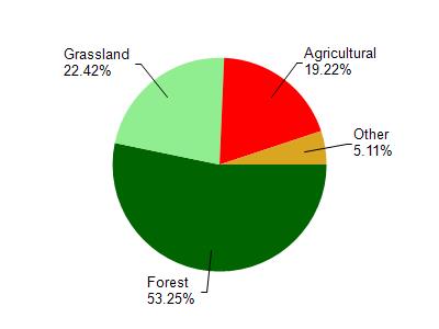
Watershed Characteristics
Mill Creek is located in the Mill and Indian Creeks watershed which is 130.32 mi². Land use in the watershed is primarily forest (53.20%), grassland (22.40%) and a mix of agricultural (19.20%) and other uses (5.10%). This watershed has 313.19 stream miles, 179.45 lake acres and 1,834.87 wetland acres.
Nonpoint Source Characteristics
This watershed is ranked High for runoff impacts on streams, Low for runoff impacts on lakes and High for runoff impacts on groundwater and therefore has an overall rank of High. This value can be used in ranking the watershed or individual waterbodies for grant funding under state and county programs.However, all waters are affected by diffuse pollutant sources regardless of initial water quality. Applications for specific runoff projects under state or county grant programs may be pursued. For more information, go to surface water program grants.