Iowa
Yes
No
Yes
Fish and Aquatic Life
Overview
Otter Creek is a tributary to the Wisconsin River. The creek has been impounded to form
Blackhawk Lake. Otter Creek is a Class II trout stream for eight miles of its length above
Dickinson Creek, (Blackhawk Lake not included). The lower 15 miles are considered a warm
water sport fishery. There are some nice smaller wetland pockets adjacent to and near Otter
Creek. The state manages several easements along Otter Creek. A rare aquatic species has
been found in the creek.
Overall, the stream has been ranked as a high priority for nonpoint source pollution reduction.
Significant nonpoint sources of water pollution in the stream's lower reaches include heavy
grazing, eroding banks, and barnyards near the creek. In the middle reach of the stream, there
are problems with cattle trampling banks which causes erosion and stream sedimentation. The
stream has been listed on the impaired waters list as a result of this severe nonpoint source
pollution.
Other impairments on the creek are the result of the impoundment in the creek's headwaters.
Blackhawk Lake's bottom discharge structure does not effectively reduce water temperatures
downstream. Surveys conducted in 1999 and 2000 found a significant increase in water
temperatures below the dam and a moderate drop in dissolved oxygen levels, some of which
were below water quality standards. In addition, fisheries surveys found few cold water
species above the dam and only a warm water forage fish community below the dam, with no
intolerant species and few cold water species present. The macroinvertebrate community was
very good above the lake and fair below the lake. The lake also experiences algae blooms as
a result of nutrient loading in the lake.
From: Ripp, Coreen, Koperski, Cindy and Folstad, Jason. 2002. The State of the Lower Wisconsin River Basin. PUBL WT-559-2002. Wisconsin Department of Natural Resources, Madison, WI.
Date 2002
Author Cynthia Koperski
Historical Description
Otter Creek is a tributary to the Wisconsin River. It is a Class II trout stream for eight miles of its lengh (WDNR, 1980). Significant nonpoint sources of water pollution in the stream's lower reaches include heavy grazing, exposed and eroding anks, and at least one nearby barnyard. The stream has a sediment problem in this lower reach (WDNR, 1991, Morton, 1991-1992). In the middle reach of the stream, there are problems with cattle trampling banks, causing erosion and stream sedimentation (WDNR, 1991). There are some nice smaller wetland pockets acjacent and near Otter Creek (WDNR, 1991).
Date 1994
Author Surface Water Inventory Of Wisconsin
Historical Description
From Dickinson Creek to Baker Creek, excluding Blackhawk Lake (class 2).
Date 1980
Author Surface Water Inventory Of Wisconsin
Historical Description
Otter Creek - Mouth location T8N R3E Section 19 -5, Surface area = 43.3 acres, Length = 21.9 miles, Gradient = 18.7 feet per mile, Total alkalinity = 249.0 mg/l, Volume of flow = 28.2 cfs.
Otter Creek is a spring and seepage fed stream which begins on the Niagara escarpment of the cuesta which is part of the Galena-Black River Uplands and flows northerly as one of the largest streams tributary to the Wisconsin River in Iowa County. Excluding the Wisconsin River it has the fourth largest volume of flow and the fourth largest watershed of all the streams which lie wholly within the county. Principal tributaries are Penn Hollow Creek, Pompey Pillar Creek, Dickinson Creek, Narveson Creek, Flint Creek and the Harker Lee Creek. They have a total base flow of 19.0 cfs which is approximately 67 percent of Otter Creek's total. The major land uses in the watershed is that of cattle pasture and cropland with almost 100 percent of it being devoted to these enterprises. As a result of intensive and land use steep and rugged topography, surface runoff during periods of heavy precipitation is very rapid with resultant floods and erosion with general losses of crops and real property. Because of this an Otter Creek Watershed Plan, inaugurated by state and federal agencies under Public Law 566, was prepared. Under this plan six structures are to be built on Otter Creek and its tributaries. One of these will be a multi-purpose structure with a permanent pool. This pool will be formed by damming Otter Creek (Cave Hollow) and Narveson Creek just above their confluence and will be called Blackhawk Lake. Four of these structures are strictly for erosion control and will be located on Pompey Pillar Creek, Smokey Hollow Creek, Harker Lee Creek, and Flint Creek. The sixth structure scheduled for Morrey Creek will have a wet pool.
Possible sources of pollution in the watershed exists in six cheese factories, two of which are located on the mainstream and four on tributaries. Their operation is closely checked by the Division of Environmental Protection.
The sport fishery of this stream is well rounded and very productive. The lower sections contain principally smallmouth bass and catfish but northern pike, walleyes, warmouth bass and bluegills are present. The game fish population of the upper sections is predominately brown trout but some rainbow and brook trout are present. Nine farm ponds which have been surveyed and a sportsmen's rearing pond also contribute to the overall fish production of the watershed. There is also a large and varied forage and rough fish population in the mainstream which includes bluntnose and suckermouth minnows; emerald, bigmouth, common and spotfin shiners; creek and hornyhead chubs; hog and white suckers; johnny darters, brook silversides, redhorse and carp. Aquatic game assets include muskrats throughout most of its length, woodduck, blue-winged teal, green herons and blue herons. There is a public boat landing with parking at the mouth which serves as access for both lower Otter Creek and the Wisconsin River. There are no public lands on the stream but it is accessible from 14 road crossings located throughout its length.
From: Piening, Ronald and Threinen, C.W., 1968. Lake and Stream Classification Project. Surface Water Resources of Iowa County, Wisconsin Department of Natural Resources, Madison, WI.
Date 1968
Author Surface Water Inventory Of Wisconsin
Impaired Waters
Otter Creek (WBIC 1237100) from its mouth to Baker Creek was listed for Sediment in 1998. The TMDL for sediment was approved in 2008. The creek from its mouth to Dickinson Creek was listed for Total Phosphorus in 2014. The creek from Dickinson Creek to Blackhawk Lake dam was listed for Elevated Water Temperature in 2016.
Date 2017
Author Ashley Beranek
Condition
Wisconsin has over 84,000 miles of streams, 15,000 lakes and milllions of acres of wetlands. Assessing the condition of this vast amount of water is challenging. The state's water monitoring program uses a media-based, cross-program approach to analyze water condition. An updated monitoring strategy (2015-2020) is now available. Compliance with Clean Water Act fishable, swimmable standards are located in the Executive Summary of Water Condition in 2018. See also the 'monitoring and projects' tab.
Reports
Recommendations
TMDL Implementation
Otter Creek is impaired due to degraded habitat because of excessive sediment loading from surrounding agricultural lands to the Creek. Otter Creek is currently not meeting the applicable narrative water quality standard (WQS) that prohibits objectionable deposits on the shore or in the bed of a water in amounts that interfere with public rights in the water. To address the degraded habitat impairments, Wisconsin Department of Natural Resources (WDNR) determined that sediment, specifically TSS, is the pollutant that must be addressed to attain designated uses and meet WQS.
TMDL (USEPA) Approved
TMDL approved for three TSS TMDLs which will address the degraded habitat impairment on Otter Creek in Iowa County. Otter Creek is impaired due to degraded habitat because of excessive sediment loading from surrounding agricultural lands to the Creek. Otter Creek is currently not meeting the applicable narrative water quality standard (WQS) that prohibits objectionable deposits on the shore or in the bed of a water in amounts that interfere with public rights in the water.
Monitor Baseline Survey
Baseline monitoring should be conducted on Otter Creek.
Management Goals
Wisconsin's Water Quality Standards provide qualitative and quantitative goals for waters that are protective of Fishable, Swimmable conditions [Learn more]. Waters that do not meet water quality standards are considered impaired and restoration actions are planned and carried out until the water is once again fishable and swimmable
Management goals can include creation or implementation of a Total Maximum Daily Load analysis, a Nine Key Element Plan, or other restoration work, education and outreach and more. If specific recommendations exist for this water, they will be displayed below online.
Monitoring
Monitoring the condition of a river, stream, or lake includes gathering physical, chemical, biological, and habitat data. Comprehensive studies often gather all these parameters in great detail, while lighter assessment events will involve sampling physical, chemical and biological data such as macroinvertebrates. Aquatic macroinvertebrates and fish communities integrate watershed or catchment condition, providing great insight into overall ecosystem health. Chemical and habitat parameters tell researchers more about human induced problems including contaminated runoff, point source dischargers, or habitat issues that foster or limit the potential of aquatic communities to thrive in a given area. Wisconsin's Water Monitoring Strategy was recenty updated.
Grants and Management Projects
Monitoring Projects
| WBIC | Official Waterbody Name | Station ID | Station Name | Earliest Fieldwork Date | Latest Fieldwork Date | View Station | View Data |
|---|
| 1237100 | Otter Creek | 10016198 | Otter Creek - 740 M Upstream Union Valley Road | 11/11/2003 | 11/11/2003 | Map | Data |
| 1237100 | Otter Creek | 10016385 | Otter Creek - 1000 M Upstream Union Valley Road | 11/11/2003 | 11/11/2003 | Map | Data |
| 1237100 | Otter Creek | 10014376 | Otter Creek-Union Valley Rd | 6/7/2006 | 6/7/2006 | Map | Data |
| 1237100 | Otter Creek | 10029566 | Otter Creek Union Valley Road Bridge | 11/3/2008 | 1/1/2015 | Map | Data |
| 1237100 | Otter Creek | 253169 | Otter Creek Union Valley Rd. (Near Mt Hope Rd.) | 9/5/2000 | 9/18/2019 | Map | Data |
| 1237100 | Otter Creek | 10015227 | Otter Creek Survey | | | Map | Data |
| 1237100 | Otter Creek | 10012290 | Otter Creek - Entrance To Blackhawk Lake | 5/1/2006 | 9/25/2020 | Map | Data |
|
Watershed Characteristics
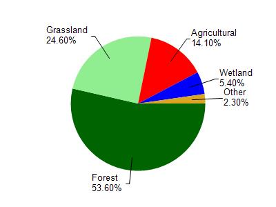
Otter Creek is located in the Otter and Morrey Creeks watershed which is 198.69 mi². Land use in the watershed is primarily forest (53.60%), grassland (24.60%) and a mix of agricultural (14.10%) and other uses (7.70%). This watershed has 437.57 stream miles, 351.55 lake acres and 5,785.74 wetland acres.
Nonpoint Source Characteristics
This watershed is ranked Not Ranked for runoff impacts on streams, Low for runoff impacts on lakes and High for runoff impacts on groundwater and therefore has an overall rank of High. This value can be used in ranking the watershed or individual waterbodies for grant funding under state and county programs.However, all waters are affected by diffuse pollutant sources regardless of initial water quality. Applications for specific runoff projects under state or county grant programs may be pursued. For more information, go to surface water program grants.