Richland, Sauk
Yes
No
No
Fish and Aquatic Life
Overview
Bear Creek rises in western Sauk County and flows south, meeting the Wisconsin River west of Lone Rock in Richland County. About 12 of its 27 stream miles are classified as Class II trout waters and the stream supports some natural reproduction of brook and brown trout. The Sauk County portion of the stream has better trout stream habitat. It has been recommended that the trout water should begin above Highway 130 and reach 12.2 miles into Sauk County.
The lower eight miles of Bear Creek are considered warm water sport fishery waters and smallmouth bass, northern pike and catfish may enter the lower reaches from the Wisconsin River. A rare aquatic species has been found in the creek in past surveys. Portions of the creek have been straightened resulting in lost habitat, temperature increases, and sedimentation problems in some areas, particularly in the stream's lower reaches. Some extensive wetland areas exist along Bear Creek. These wetlands buffer the creek and provide habitat. Baseline monitoring was conducted on the stream in 2001.
From: Ripp, Coreen, Koperski, Cindy and Folstad, Jason. 2002. The State of the Lower Wisconsin River Basin. PUBL WT-559-2002. Wisconsin Department of Natural Resources, Madison, WI
Date 2002
Author Cynthia Koperski
Historical Description
Bear Creek rises in western Sauk County and flows south, meeting the Wisconsin River
west of Lone Rock. About 12 of its 27 stream nliles are classified as Class II trout waters
(WDNR, 1980). The lower eight miles are considered warm water sport fishery waters
(WDNR, 1991). The Richland County portion of the waterslaed is thought to have a high
potential for water quality due to soil erosion and livestock (Eagan, 1985~). Sediment is
a suspected water quality problem particularly in the streams lower reaches (Eagan, 1985,
WDNR, 1991, Schlesser, 1991-1992). Some cattle access the stream (WDNR 1991).
Portions of the stream were straightened resulting in lost habitat, temperature
increases, and sedimentation problems in some areas (Eagan, 1985 ). Some extensive
wetlands areas exist which buffer the creek and provide habitat (WDNR, 1991). A state
fishery area has been proposed for portions of the creek (WDNR, 1991).
Date 1994
Author Surface Water Inventory Of Wisconsin
General Condition
Bear Creek is a clear, hard water stream that flows in a westerly direction and joins the Kickapoo River at La Farge. It heads at the junction of the North and South Branches of the stream. Bear Creek is managed as Class III brown trout water. Many forage species and brook lamprey are also found. The winter aerial groundwater survey found a small amount of open water near the mouth of the creek. Sand is the dominant bottom type, but there is considerable rubble, some silt, and a little hardpan and gravel. Bank erosion is severe. The Kickapoo River and one road crossing provides access. Muskrat are significant and a small number of migrant puddle ducks use the stream.
Bear Creek, T13N, R2W, Section 32. Surface Acres = 2.9, Miles = 1.6, Gradient = 20.0 feet per mile.
From: Klick, Thomas A. and Threinen, C.W., 1973. Lake and Stream Classification Project. Surface Water Resources of Vernon County, Department of Natural Resources, Madison, WI.
Date 1973
Author Aquatic Biologist
Impaired Waters
The 2018 assessments of Bear Creek (miles 0-8.2) showed continued impairment by phosphorus; new total phosphorus sample data overwhelmingly exceeded the 2018 WisCALM listing criteria for the Fish and Aquatic Life use. However, available biological data did not indicate impairment (i.e. no macroinvertebrate or fish Index of Biotic Integrity (IBI) scored in the "poor" condition category). Based on the most updated information, no change in the existing impaired waters listing was needed.
Date 2017
Author Ashley Beranek
Impaired Waters
Bear Creek (1234600) from the mouth to the second crossing of Highway 130 (0 - 8 miles) was listed for total phosphorus impairment in 2012. The 2016 assessments showed continued impairment by phosphorus; total phosphorus sample data overwhelmingly exceed 2016 WisCALM listing thresholds for the Fish and Aquatic Life use, however, available biological data do not indicate impairment (i.e. no macroinvertebrate or fish Index of Biotic Integrity (IBI) scored in the "poor" condition category). Based on the most updated information, no change in existing impaired waters listing is needed.
Date 2015
Author Aaron Larson
Condition
Wisconsin has over 84,000 miles of streams, 15,000 lakes and milllions of acres of wetlands. Assessing the condition of this vast amount of water is challenging. The state's water monitoring program uses a media-based, cross-program approach to analyze water condition. An updated monitoring strategy (2015-2020) is now available. Compliance with Clean Water Act fishable, swimmable standards are located in the Executive Summary of Water Condition in 2018. See also the 'monitoring and projects' tab.
Reports
Recommendations
Water Quality Planning
Bear Creek (LW14) Watershed Planning
Monitor Water Quality or Sediment
New listing based on new data. Temperature listing based on 2016 exceedances. Earlier data, specifically 2014, appears to have errors. Based on biologist experience: Bear Cr. was restored during August-Oct., which could greatly skew the TP results while work was being done. Further monitoring recommended.
Monitor Targeted Area
Monitor sloughs more closely to help determine cause of nutrient loads, excessive filamentous algae growth, and levels of nitrates.
Trout Classification Mgmt
Increase the trout stream mileage in the Sauk County portion of Bear Creek.
Rivers Management Grant
Funding for stream restoration projects could also be obtained from the Conservation Reserve Enhancement Program (CREP), Wildlife Habitat Incentive Program (WHIP), and State Targeted Runoff Management (TRM) grants.
Restore Wetlands
Restore filled, ditched and drained wetlands along Bear Creek and its tributaries through WRP and EQIP programs offered by Richland and Sauk County NRCS and by other cost-sharing programs such as CREP, US Fish & Wildlife Services Partners for Fish and Wildlife program and easements.
Easement/Buffer
Land should be acquired or easements purchased from willing buyers along the Bear and Little Bear Creeks to aid in habitat improvement work.
TMDL Monitoring
Propose Bear Creek for TMDL monitoring.
Management Goals
Wisconsin's Water Quality Standards provide qualitative and quantitative goals for waters that are protective of Fishable, Swimmable conditions [Learn more]. Waters that do not meet water quality standards are considered impaired and restoration actions are planned and carried out until the water is once again fishable and swimmable
Management goals can include creation or implementation of a Total Maximum Daily Load analysis, a Nine Key Element Plan, or other restoration work, education and outreach and more. If specific recommendations exist for this water, they will be displayed below online.
Monitoring
Monitoring the condition of a river, stream, or lake includes gathering physical, chemical, biological, and habitat data. Comprehensive studies often gather all these parameters in great detail, while lighter assessment events will involve sampling physical, chemical and biological data such as macroinvertebrates. Aquatic macroinvertebrates and fish communities integrate watershed or catchment condition, providing great insight into overall ecosystem health. Chemical and habitat parameters tell researchers more about human induced problems including contaminated runoff, point source dischargers, or habitat issues that foster or limit the potential of aquatic communities to thrive in a given area. Wisconsin's Water Monitoring Strategy was recenty updated.
Grants and Management Projects
Monitoring Projects
| WBIC | Official Waterbody Name | Station ID | Station Name | Earliest Fieldwork Date | Latest Fieldwork Date | View Station | View Data |
|---|
| 1234600 | Bear Creek | 10008219 | Bear Creek Station 1 - Sth 130 | 10/31/2001 | 10/31/2001 | Map | Data |
| 1234600 | Bear Creek | 10051473 | Bear Creek at St. Killians Rd. | | | Map | Data |
| 1235700 | Marble Creek | 10016598 | Bear Creek US Weitzel Road | 10/31/2001 | 12/2/2013 | Map | Data |
| 1234600 | Bear Creek | 10051316 | Bear Creek 30m Upstream of Weitzel Rd | | | Map | Data |
|
Watershed Characteristics
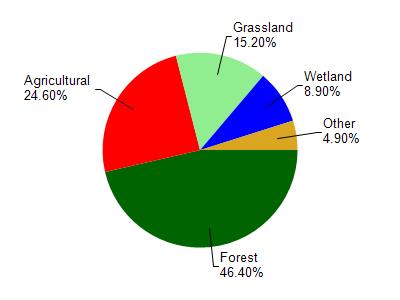
Bear Creek is located in the Bear Creek watershed which is 136.54 mi². Land use in the watershed is primarily forest (46.40%), agricultural (24.60%) and a mix of grassland (15.20%) and other uses (13.80%). This watershed has 236.07 stream miles, 119.46 lake acres and 6,798.61 wetland acres.
Nonpoint Source Characteristics
This watershed is ranked Medium for runoff impacts on streams, Not Ranked for runoff impacts on lakes and High for runoff impacts on groundwater and therefore has an overall rank of High. This value can be used in ranking the watershed or individual waterbodies for grant funding under state and county programs.However, all waters are affected by diffuse pollutant sources regardless of initial water quality. Applications for specific runoff projects under state or county grant programs may be pursued. For more information, go to surface water program grants.