Iowa
No
No
Yes
Fish and Aquatic Life
Overview
Twin Valley Lake is located in Iowa County just below Cox Hollow Lake and is an
impoundment on the headwaters of Mill Creek. The lake is 152 acres with a maximum depth
of 32 feet. The lake is located wholly inside of Governor Dodge State Park and was
constructed in 1967 for wildlife habitat, recreation and as a flood control structure. The
fishery of Twin Valley Lake is musky walleye, largemouth bass, panfish and trout.
Monitoring on Twin Valley Lake began in 2001.
Date 1999
Author Aquatic Biologist
Historical Description
Source: 1968, Surface Water Resources of Iowa County,WI: WI-DNR Twin Valley Lake, T67N, R34E, Sections 1, 2, 11, 35, 36
Twin Valley Lake is an impoundment of Mill Creek just below Cox Hollow Lake in the 4,600 acre of Governor Dodge State Park. The dam was constructed in 1965-66 as part of the Twin Parks Watershed Project sponsored by the Federal Government and the lake was created in early 1967. Most of the water is received from Mill Creek and several small tributaries; however, there are also a number of large springs in the basin. Most of the watershed was farmed until recently and has since been allowed to revert to its natural state. This has provided more stable land cover. The Bureau of Research has included this lake in its impoundment studies. The fishery consists of species of fish which were present in the stream before it was impounded. Some of these were received from Cox Hollow Lake. Gamefish which are common include largemouth bass, northern pike, and brown trout. Panfish include bluegills, crappies, and bullheads. Forage species which are present include white suckers, bluntnose minnows, common shiners, creek chubs and hornyhead chubs. Aquatic game assets consist of muskrats which are abundant and possibly some beaver. Waterfowl consist of most species commonly found in Wisconsin and include mallards, blue-winged teal, coots and Canada geese. The greatest variety is present during the spring and fall migrations. Since it is located in a state park, access is adequate. A large launching site with ample parking has been constructed. Campgrounds and a swimming beach are planned to expand the recreational facilities.
Surface Acres = 145, S.D.F. = 1.8, Maximum depth = 35 feet
Date 1968
Author Surface Water Inventory Of Wisconsin
General Condition
Governor Dodge State Park Twin Valley Beach was assessed for the 2018 listing cycle; E. coli data sample data were clearly below the 2018 WisCALM listing thresholds for the Recreation use. This beach was meeting this designated use and was not considered impaired.
Date 2017
Author Ashley Beranek
Impaired Waters
Twin Valley Lake (WBIC 1245800) was placed on the impaired waters list for excess algal growth in 2016. The 2018 assessments showed continued excess algal growth; new chlorophyll-a sample data exceeded the 2018 WisCALM listing thresholds for the Recreation use. Based on the most updated information, no change in the existing impaired waters listing was needed.
Date 2017
Author Ashley Beranek
Impaired Waters
Twin Valley Lake (WBIC 1245800) was assessed during the 2016 listing cycle; chlorophyll sample data exceed 2016 WisCALM listing thresholds for the Recreation use, however, total phosphorus data do not exceed REC thresholds. Total phosphorus and chlorophyll data do not exceed Fish and Aquatic Life thresholds.
Date 2015
Author Aaron Larson
Condition
Wisconsin has over 84,000 miles of streams, 15,000 lakes and milllions of acres of wetlands. Assessing the condition of this vast amount of water is challenging. The state's water monitoring program uses a media-based, cross-program approach to analyze water condition. An updated monitoring strategy (2015-2020) is now available. Compliance with Clean Water Act fishable, swimmable standards are located in the Executive Summary of Water Condition in 2018. See also the 'monitoring and projects' tab.
Reports
Management Goals
Wisconsin's Water Quality Standards provide qualitative and quantitative goals for waters that are protective of Fishable, Swimmable conditions [Learn more]. Waters that do not meet water quality standards are considered impaired and restoration actions are planned and carried out until the water is once again fishable and swimmable
Management goals can include creation or implementation of a Total Maximum Daily Load analysis, a Nine Key Element Plan, or other restoration work, education and outreach and more. If specific recommendations exist for this water, they will be displayed below online.
Monitoring
Monitoring the condition of a river, stream, or lake includes gathering physical, chemical, biological, and habitat data. Comprehensive studies often gather all these parameters in great detail, while lighter assessment events will involve sampling physical, chemical and biological data such as macroinvertebrates. Aquatic macroinvertebrates and fish communities integrate watershed or catchment condition, providing great insight into overall ecosystem health. Chemical and habitat parameters tell researchers more about human induced problems including contaminated runoff, point source dischargers, or habitat issues that foster or limit the potential of aquatic communities to thrive in a given area. Wisconsin's Water Monitoring Strategy was recenty updated.
Grants and Management Projects
Monitoring Projects
| WBIC | Official Waterbody Name | Station ID | Station Name | Earliest Fieldwork Date | Latest Fieldwork Date | View Station | View Data |
|---|
| 1245800 | Twin Valley Lake | 10018030 | Twin Valley Lake -- Launch | 5/6/2006 | 1/23/2018 | Map | Data |
| 1245800 | Twin Valley Lake | 253201 | Twin Valley Lake - Govenor Dodge State Park Beach | 6/3/2003 | 9/6/2023 | Map | Data |
| 1245800 | Twin Valley Lake | 10002729 | Twin Valley Lake | 6/1/1989 | 9/30/2017 | Map | Data |
| 1245800 | Twin Valley Lake | 10015109 | Twin Valley Lake Baseline | 8/7/2014 | 8/7/2014 | Map | Data |
| 1245800 | Twin Valley Lake | 253127 | Twin Valley Lake - Deep Hole | 8/13/2001 | 4/10/2024 | Map | Data |
|
Watershed Characteristics
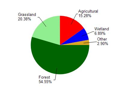
Twin Valley Lake is located in the Mill and Blue Mounds Creek watershed which is 186.74 mi². Land use in the watershed is primarily forest (54.60%), grassland (20.40%) and a mix of agricultural (15.30%) and other uses (9.80%). This watershed has 382.87 stream miles, 106.91 lake acres and 6,596.99 wetland acres.
Nonpoint Source Characteristics
This watershed is ranked Medium for runoff impacts on streams, Low for runoff impacts on lakes and High for runoff impacts on groundwater and therefore has an overall rank of High. This value can be used in ranking the watershed or individual waterbodies for grant funding under state and county programs.However, all waters are affected by diffuse pollutant sources regardless of initial water quality. Applications for specific runoff projects under state or county grant programs may be pursued. For more information, go to surface water program grants.