Richland, Sauk
No
Yes
No
Fish and Aquatic Life
Overview
Long Lake is a drainage oxbow lake of the Wisconsin River located in both Sauk and Richland Counties and is considered an Exceptional Resource Water (ERW). The lake is impounded near Brace Memorial Park, which is near Lone Rock. The lake has an area of 48 acres and a maximum depth of 10 feet. The lake is a very popular fishing lake and contains northern pike, walleye, largemouth bass, panfish and catfish. The lake has some problems as a result of low dissolved oxygen. The lake suffered from a serious fish kill in 1995. The kill was thought to be the result of excessive biological oxygen demand, BOD, in two upstream lakes that are the source of water for Long Lake.
Overall, Long Lake is susceptible to problems as a result of activities in the upstream ponds. Long Lake is a part of a 'Shallow Lakes Initiative' that began in 1998 to document resource values and problems in shallow waters of the Wisconsin River.
Date 2002
Author Aquatic Biologist
Historical Description
A drainage oxbow lake of the Wisconsin River impounded by a low head dam adjacent to Brace Memorial Park one mile south of Lone Rock. This lake is a popular fishing attraction for this part of the county. Largemouth bass, northern pike and walleye are the principal sport fish. Catfish and panfish are also present. Ice fishing for northern pike is a popular activity for local residents. Carp, buffalo, white suckers, bowfin and gizzard shad are abundant but do not appear to cause a severe use problem. Game assets include muskrat, beaver, mink, puddle ducks, deer, and squirrels. Public access is possible from Brace Memorial Park, McKenna Park, one road ending, Public Hunting and Fishing Grounds on the eastern end of the lake, and from the Wisconsin River. A boat launching ramp is provided in McKenna Park. Twenty-six dwellings are found along the northern shore.
Surface area 48.0 acres, S.D.F. = 1.03, Maximum depth 10 feet
Source: 1971, Surface Water Resources of Sauk County Long Lake T8N R3E, Sec. 17, 18
Date 1971
Author Aquatic Biologist
Condition
Wisconsin has over 84,000 miles of streams, 15,000 lakes and milllions of acres of wetlands. Assessing the condition of this vast amount of water is challenging. The state's water monitoring program uses a media-based, cross-program approach to analyze water condition. An updated monitoring strategy (2015-2020) is now available. Compliance with Clean Water Act fishable, swimmable standards are located in the Executive Summary of Water Condition in 2018. See also the 'monitoring and projects' tab.
Reports
Management Goals
Wisconsin's Water Quality Standards provide qualitative and quantitative goals for waters that are protective of Fishable, Swimmable conditions [Learn more]. Waters that do not meet water quality standards are considered impaired and restoration actions are planned and carried out until the water is once again fishable and swimmable
Management goals can include creation or implementation of a Total Maximum Daily Load analysis, a Nine Key Element Plan, or other restoration work, education and outreach and more. If specific recommendations exist for this water, they will be displayed below online.
Monitoring
Monitoring the condition of a river, stream, or lake includes gathering physical, chemical, biological, and habitat data. Comprehensive studies often gather all these parameters in great detail, while lighter assessment events will involve sampling physical, chemical and biological data such as macroinvertebrates. Aquatic macroinvertebrates and fish communities integrate watershed or catchment condition, providing great insight into overall ecosystem health. Chemical and habitat parameters tell researchers more about human induced problems including contaminated runoff, point source dischargers, or habitat issues that foster or limit the potential of aquatic communities to thrive in a given area. Wisconsin's Water Monitoring Strategy was recenty updated.
Grants and Management Projects
| Project Name (Click for Details) | Year Started |
|---|
|
|
Monitoring Projects
| WBIC | Official Waterbody Name | Station ID | Station Name | Earliest Fieldwork Date | Latest Fieldwork Date | View Station | View Data |
|---|
| 1236600 | Long Lake | 10043282 | Long Lake main channel south of McKenna Rd. | 3/5/2015 | 8/6/2025 | Map | Data |
| 1236600 | Long Lake | 10005281 | Long Lake | 6/1/1992 | 9/22/2017 | Map | Data |
| 1236600 | Long Lake | 10043281 | Long Lake DS of tin whistle dam | 3/5/2015 | 8/6/2025 | Map | Data |
| 1236600 | Long Lake | 10017531 | Long Lake -- Access | 6/25/2012 | 7/9/2021 | Map | Data |
| 1236600 | Long Lake | 10018169 | Long Lake -- Firemans Park Access | 6/25/2012 | 7/9/2021 | Map | Data |
| 1236600 | Long Lake | 10020295 | Long Lake -- Laudon Park Landing | 6/25/2012 | 9/30/2013 | Map | Data |
| 1236600 | Long Lake | 573057 | Long Lake - Deep Hole | 7/1/1980 | 10/29/2025 | Map | Data |
| 1236600 | Long Lake | 10029027 | Long Lake - near Laudon Park Road | 8/6/2008 | 8/25/2025 | Map | Data |
|
Watershed Characteristics
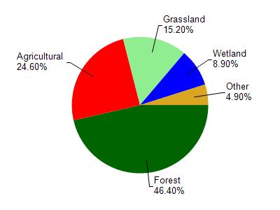
Long Lake is located in the Bear Creek watershed which is 136.54 mi². Land use in the watershed is primarily forest (46.40%), agricultural (24.60%) and a mix of grassland (15.20%) and other uses (13.80%). This watershed has 236.07 stream miles, 119.46 lake acres and 6,798.61 wetland acres.
Nonpoint Source Characteristics
This watershed is ranked Medium for runoff impacts on streams, Not Ranked for runoff impacts on lakes and High for runoff impacts on groundwater and therefore has an overall rank of High. This value can be used in ranking the watershed or individual waterbodies for grant funding under state and county programs.However, all waters are affected by diffuse pollutant sources regardless of initial water quality. Applications for specific runoff projects under state or county grant programs may be pursued. For more information, go to surface water program grants.