Sauk
Yes
No
No
Fish and Aquatic Life
Overview
Honey Creek is a Class II trout stream for about 6 miles from Willow Road up to County
Highway GG. Downstream from these trout waters, Honey Creek flows an additional 26
miles and supports a warm water sport fishery, and the seasonal migration of gamefish from
the Wisconsin River during the summer. All of the tributaries that flow into Honey Creek are
considered warm water fisheries. A rare aquatic species has been found in the creek in past
surveys.
The creek has been affected by hydrologic modification. The upper reaches of the main
branch of Honey Creek above the Village of Plain, and Shannahan Valley Creek, were
dammed in 1970, forming the 104-acre White Mound Lake. This structure was built for flood
and erosion control. This impoundment now supports a warm water fishery instead of a cold
water fishery. The stream is also influenced by intense agricultural activities that take place
adjacent to the stream and are suspected of causing habitat and water quality problems.
Stream straightening, cattle trampling streambanks and subsequent bank erosion, cultivated
fields up to the edge of Honey Creek and its tributaries, and wetland drainage have resulted in
sedimentation problems in the stream. The most obvious example of this is the silt and
sediment delta forming in the Wisconsin River at the mouth of Honey Creek. Manure
handling and storage problems also exist on or near Honey Creek. In addition, Honey Creek
receives industrial discharge from a cheese factory.
Fish surveys to determine the health of the stream downstream from the impoundment have
found the stream to be poor, reflecting the warm water temperature that result from the
impoundment and the impacts of agricultural land use. With a recent conversion of the
discharge of White Mound Lake from a top (warmwater) to bottom (coldwater) draw, stream
temperatures downstream to Plain have become more favorable for trout. A summer 2000
survey even found significant brown trout reproduction in one area of the stream. With
easement purchases to eliminate cropping and grazing next to the stream and instream habitat
improvement, this stretch of stream has potential for trout management again. (See White
Mound Lake).
From: Ripp, Coreen, Koperski, Cindy and Folstad, Jason. 2002. The State of the Lower Wisconsin River Basin.
PUBL WT-559-2002. Wisconsin Department of Natural Resources, Madison, WI.
Date 2002
Author Cynthia Koperski
Historical Description
Honey Creek is a Class II trout stream for 4.2 miles (WDNR, 1991) of its 32-mile length.
Another 26.5 miles are classed as warm water sport fishery (WDNR, 1991). Intense
agricultural activities take place adjacent to the stream and are suspected of causing
habitat and water quality problems (Schlesser, 1991 - 1992). Stream straightening,
cattle trampling streambanks and subsequent bank erosion, cultivated fields up to the
edge of Honey Creek and its tributaries, and wetland drainage have resulted in
sedimentation problems in the stream. The most obvious example of this is the silt and
sediment delta forming in the Wisconsin River at the mouth of Honey Creek (WDNR.
1988, Gjestson, 1991). Manure handling and storage problems also exist on or near
Honey Creek (WDNR, 1991).
Date 1994
Author Surface Water Inventory Of Wisconsin
Impaired Waters
Honey Creek was recently evaluated during the ten-year period of 2009 through 2018 for results that were reported to the USEPA for the 2020 Clean Water Act condition report. The waterbody is considered impaired, or in poor condition for designated uses which include the quality of fish and aquatic life, recreational use, and public health and welfare (fish consumption and related). Pollutants or problems encountered during sampling (impairments) are determined based on water quality standards outlined in Wisconsin 2020 Consolidated Assessment and Listing Methodology (WisCALM). Assessment results show water conditions that are potentially harmful for Aquatic Life use due to values for temperature that fall into the range expected for an aquatic community in poor health, therefore this water is listed as impaired.
Honey Creek (mile 0-25.54): This segment has been listed since 2012 for total phosphorus causing degraded biological community.
Honey Creek (mile 25.54-30.46): Assessment results during the 2020 listing cycle show elevated water temperature levels inappropriate for Aquatic Life use according to 2020 WisCALM standards. Available bug and fish sample data (macroinvertebrate and fish Index of Biotic Integrity) do not indicate impairment. This segment was listed in 2014 for degraded biological community. Elevated water temperature by an unknown pollutant was added to the listing for this already impaired water.
Honey Creek [2 segments (mile 30.46-33.83)]: These segments are either attaining their designated uses or there is not enough information to assess condition.
Date 2019
Author Ashley Beranek
Impaired Waters
Honey Creek (WBIC 1253900) from Willow Road (near Plain) to CTH GG was placed on the impaired waters list for degraded biological community in 2014. This water was assessed during the 2018 listing cycle; new biological (fish Index of Biotic Integrity (IBI) scores) sample data were clearly below 2018 WisCALM listing thresholds for the Fish and Aquatic Life use. The degraded biological community listing was based on macroinvertebrate data so this water was not be delisted at the time.
Date 2017
Author Ashley Beranek
Condition
Wisconsin has over 84,000 miles of streams, 15,000 lakes and milllions of acres of wetlands. Assessing the condition of this vast amount of water is challenging. The state's water monitoring program uses a media-based, cross-program approach to analyze water condition. An updated monitoring strategy (2015-2020) is now available. Compliance with Clean Water Act fishable, swimmable standards are located in the Executive Summary of Water Condition in 2018. See also the 'monitoring and projects' tab.
Reports
Management Goals
Wisconsin's Water Quality Standards provide qualitative and quantitative goals for waters that are protective of Fishable, Swimmable conditions [Learn more]. Waters that do not meet water quality standards are considered impaired and restoration actions are planned and carried out until the water is once again fishable and swimmable
Management goals can include creation or implementation of a Total Maximum Daily Load analysis, a Nine Key Element Plan, or other restoration work, education and outreach and more. If specific recommendations exist for this water, they will be displayed below online.
Monitoring
Monitoring the condition of a river, stream, or lake includes gathering physical, chemical, biological, and habitat data. Comprehensive studies often gather all these parameters in great detail, while lighter assessment events will involve sampling physical, chemical and biological data such as macroinvertebrates. Aquatic macroinvertebrates and fish communities integrate watershed or catchment condition, providing great insight into overall ecosystem health. Chemical and habitat parameters tell researchers more about human induced problems including contaminated runoff, point source dischargers, or habitat issues that foster or limit the potential of aquatic communities to thrive in a given area. Wisconsin's Water Monitoring Strategy was recenty updated.
Grants and Management Projects
Monitoring Projects
| WBIC | Official Waterbody Name | Station ID | Station Name | Earliest Fieldwork Date | Latest Fieldwork Date | View Station | View Data |
|---|
| 1258300 | Unnamed | 10012382 | Shaid No 36004291 | 8/10/2007 | 7/4/2011 | Map | Data |
| 1253900 | Honey Creek | 10022320 | Honey Creek-15 Meters Upstream From Kramer Bros. Pit Rd Crossing | 4/4/2008 | 1/1/2015 | Map | Data |
| 1253900 | Honey Creek | 10010995 | Honey Creek-White Mound Br From Foot Bridge To Plunge Pool Below W.M. Lake Dam | | | Map | Data |
| 1253900 | Honey Creek | 10009958 | Honey Creek - 59 Meters Upstream From Cth GG | 11/3/2003 | 11/6/2023 | Map | Data |
|
Watershed Characteristics
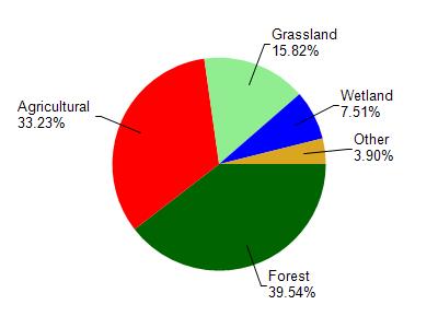
Honey Creek is located in the Honey Creek watershed which is 217.78 mi². Land use in the watershed is primarily forest (39.50%), agricultural (33.20%) and a mix of grassland (15.80%) and other uses (11.40%). This watershed has 430.53 stream miles, 301.07 lake acres and 9,324.41 wetland acres.
Nonpoint Source Characteristics
This watershed is ranked Medium for runoff impacts on streams, Not Ranked for runoff impacts on lakes and High for runoff impacts on groundwater and therefore has an overall rank of High. This value can be used in ranking the watershed or individual waterbodies for grant funding under state and county programs.However, all waters are affected by diffuse pollutant sources regardless of initial water quality. Applications for specific runoff projects under state or county grant programs may be pursued. For more information, go to surface water program grants.