Dane
Yes
No
Yes
Fish and Aquatic Life
Overview
Vermont Creek is 6 miles long and joins the Black Earth Creek just west of the Village of
Black Earth Creek. Many of the banks of creek are lined with wetlands and wet meadows.
The creek has been evaluated as a cold water stream that supports natural reproduction of
brown trout. There are some ponded spring heads on the creek and sections of the creek have
been channelized. Although a cursory habitat evaluation conducted on a headwater section of
the creek during the summer of 2001 found the creek to have good in-stream habitat, habitat
work is needed in the channelized portion of the stream. Erosion and other nonpoint sources
of pollution from the surrounding watershed were noted, but not thought to be major
problems.
Habitat restoration, sediment control, and reduction of nonpoint control would greatly
enhance the water quality and fish habitat of this stream. Habitat improvement work should be
completed in the WDNR owned section of the creek and serve as a pilot project. Access is
available from road crossings and WDNR properties and easements.
From: Ripp, Coreen, Koperski, Cindy and Folstad, Jason. 2002. The State of the Lower Wisconsin River Basin.
PUBL WT-559-2002. Wisconsin Department of Natural Resources, Madison, WI.
Date 2002
Author Cynthia Koperski
Historical Description
Vermont Creek -T8N, R6E, Sec. 26, Surface acres = 9, Length = 8 miles, Stream order = I, Gradient = 19.2 ft/mile, Base discharge = 6.4 cfs.
Vermont Creek originates in Section 13 of Vermont Township (T7N, R6E) and joins Black Earth Creek at Black Earth. It flows for the most part within a broad, flat valley alongside Hwy. 78. The surroundIng topography is hilly and the land is used for grazing and some row crops. Wet meadows are associated with the creek in some areas. Vermont Creek is sprlng-fed but several of these springs have been impounded (Dane Cty. Reg. Plann. Comm. 1979a). Adjacent lands tend to be overgrazed and some areas of the creek have been ditched, causing problems from agricultural runoff and stream bank
erosion. The water quality remains quite good.
Upper and Lower Vermont Creek are considered Class II and Class III trout streams, respectively. In 1979 and 1980, DNR-owned reaches of the creek in Sections 2 and 13 (Vermont) underwent trout habitat improvement to direct stream flow and control livestock use. Vermont Creek is popular with anglers and is of sufficient size to be navigable. Access is available at four road crossings and through DNR-owned land on the upper part of the creek. Upland hunting is available on a 42-acre DNR-owned parcel in Section 13. Waterfowl also use a sprlng-fed tributary in the same vicinity.
Fish species: brown trout, white sucker. black bullhead, and mottled sculpin.
From: Day, Elizabeth A.; Grzebieniak, Gayle P.; Osterby, Kurt M.; and Brynildson, Clifford L., 1985. Lake and Stream Classification Project. Surface Water Resources of Dane County, Wisconsin Department of Natural Resources, Madison, WI.
Date 1985
Author Surface Water Inventory Of Wisconsin
Historical Description
From the mouth to the south line of section 2, T7N R6E (class 3); for 2 miles above section 2 (class 2).
Date 1980
Author Surface Water Inventory Of Wisconsin
General Condition
This water had a large stream rehabilitation project conducted in 2010. The section from downstream of Michaelis Road to upstream of CTH JJ has under gone a major stream restoration effort.
Samples taken as part of the Black Earth Creek project in 1/12/2012 had the following results (10012507= 4.51794 Fair/ 10016009= 4.81376 Good). This is the post evaluation and results show a improvement in WQ. I would not recommend listing, habitat work has made positive changes and samples document this change.
Date 2014
Author Michael Sorge
Impaired Waters
The 2018 assessments of Vermont Creek (from WBIC 1249400 to headwaters) showed impairment by temperature; new temperature sample data exceeded the 2018 WisCALM listing criteria for the Fish and Aquatic Life use. However, available biological data do not indicate impairment (i.e. no fish Index of Biotic Integrity (IBI) scored in the "poor" condition category). Based on the most updated information, this water was proposed for the impaired waters list.
Date 2017
Author Ashley Beranek
Impaired Waters
The 2018 assessments of Vermont Creek (confluence with Black Earth Creek to the south line of S2, T7N R6E) showed impairment by phosphorus; new total phosphorus sample data exceeded the 2018 WisCALM listing criteria for the Fish and Aquatic Life use. However, available biological data did not indicate impairment. New macroinvertebrate and existing fish sample data were assessed, but no macroinvertebrate or fish Index of Biotic Integrity (IBI) scored in the "poor" condition category. Based on the most updated information, no change in the existing impaired waters listing was needed.
Date 2017
Author Ashley Beranek
Impaired Waters
Vermont Creek (1249200), from the mouth to 3.46 miles upstream, was placed on the impaired waters list for sediment/total suspended solids in 2004. This water was assessed during the 2016 listing cycle; biological sample data met 2016 WisCALM listing thresholds for the Fish and Aquatic Life use (i.e. macroinvertebrate or fish Index of Biotic Integrity (IBI) average scored in the fair to excellent condition categories).
Date 2015
Author Aaron Larson
Condition
Wisconsin has over 84,000 miles of streams, 15,000 lakes and milllions of acres of wetlands. Assessing the condition of this vast amount of water is challenging. The state's water monitoring program uses a media-based, cross-program approach to analyze water condition. An updated monitoring strategy (2015-2020) is now available. Compliance with Clean Water Act fishable, swimmable standards are located in the Executive Summary of Water Condition in 2018. See also the 'monitoring and projects' tab.
Reports
Recommendations
TMDL Implementation
Vermont Creek was identified as one of five TMDL's selected by South Central Region. This stream is currently on the 303d list for habitat and temperature with sediment being the pollutant.
Management Goals
Wisconsin's Water Quality Standards provide qualitative and quantitative goals for waters that are protective of Fishable, Swimmable conditions [Learn more]. Waters that do not meet water quality standards are considered impaired and restoration actions are planned and carried out until the water is once again fishable and swimmable
Management goals can include creation or implementation of a Total Maximum Daily Load analysis, a Nine Key Element Plan, or other restoration work, education and outreach and more. If specific recommendations exist for this water, they will be displayed below online.
Monitoring
Monitoring the condition of a river, stream, or lake includes gathering physical, chemical, biological, and habitat data. Comprehensive studies often gather all these parameters in great detail, while lighter assessment events will involve sampling physical, chemical and biological data such as macroinvertebrates. Aquatic macroinvertebrates and fish communities integrate watershed or catchment condition, providing great insight into overall ecosystem health. Chemical and habitat parameters tell researchers more about human induced problems including contaminated runoff, point source dischargers, or habitat issues that foster or limit the potential of aquatic communities to thrive in a given area. Wisconsin's Water Monitoring Strategy was recenty updated.
Grants and Management Projects
Monitoring Projects
| WBIC | Official Waterbody Name | Station ID | Station Name | Earliest Fieldwork Date | Latest Fieldwork Date | View Station | View Data |
|---|
| 1249200 | Vermont Creek | 10011931 | Vermont Creek - Cty. Rd. Kp Bridge 150 M Upstream To Fenceline | 5/20/1986 | 7/21/2020 | Map | Data |
| 1249200 | Vermont Creek | 10009346 | Vermont Creek At Danz Culvert (Black Earth S26) | | | Map | Data |
| 1249200 | Vermont Creek | 10016009 | Vermont - Cth Jj. | 5/20/1986 | 12/4/2019 | Map | Data |
| 1249200 | Vermont Creek | 10015267 | Vermont Creek - Upstream Of Michaelis Rd 183 M To End Gps | | | Map | Data |
| 1249200 | Vermont Creek | 10014195 | Vermont Creek - Cowan Picnic Area To First Beaver Dam | | | Map | Data |
| 1249200 | Vermont Creek | 10016103 | Vermont Cr. - 83 M Upstream Danz Property Bridge/Culvert | 11/11/2002 | 1/1/2015 | Map | Data |
| 1249200 | Vermont Creek | 10012507 | Vermont Creek At Michaelis Road | 10/31/2006 | 12/4/2019 | Map | Data |
| 1249200 | Vermont Creek | 10015889 | Vermont Creek - 100 M Upstream Hwy. Jj Bridge. | 5/21/1998 | 5/21/1998 | Map | Data |
| 1249200 | Vermont Creek | 10015863 | Unnamed Trib. - Hwy 14 At Confuence With Blackearth Creek | 5/1/1987 | 5/7/1990 | Map | Data |
| 1249200 | Vermont Creek | 10034044 | Vermont Cr. 300m US CTH KP. Parrell Property | 1/1/2015 | 8/7/2015 | Map | Data |
|
Watershed Characteristics
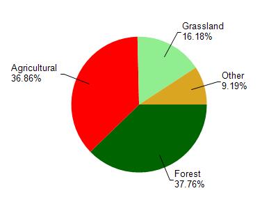
Vermont Creek is located in the Black Earth Creek watershed which is 105.20 mi². Land use in the watershed is primarily forest (37.80%), agricultural (36.90%) and a mix of grassland (16.20%) and other uses (9.20%). This watershed has 196.86 stream miles, 204.29 lake acres and 1,541.75 wetland acres.
Nonpoint Source Characteristics
This watershed is ranked Not Available for runoff impacts on streams, Not Available for runoff impacts on lakes and High for runoff impacts on groundwater and therefore has an overall rank of High. This value can be used in ranking the watershed or individual waterbodies for grant funding under state and county programs.This water is ranked High Stream for individual Rivers based on runoff problems and the likelihood of success from project implementation.