")
5.79 Acres
Small
2020
Poor
Excess Algal Growth, Eutrophication
Total Phosphorus
Dane
No
No
Yes
Fish and Aquatic Life
Overview
Stewart Lake is a seven-acre impoundment at the headwaters of Moen Creek. A small county park surrounds the lake. The lake experiences algae blooms and has excessive aquatic plant growth (Day, 1985). Stormwater runoff from the village of Mt. Horeb is thought to be part of the problem. With help through funding through the Lake Protection Grant program, the City of Mount Horeb is constructing stormwater detention basins to reduce sediment delivery to the lake.
Dane County has a state lake management planning grant to develop a plan to address nonpoint source pollution and to improve in-lake management techniques. Dane County and the U.S. Geological Survey have begun lake and sediment monitoring in order to better understand and address the problems of the lake.
Date 2002
Author Aquatic Biologist
Historical Description
Stewart Lake is a seven-acre inlpoundment at the headwaters of Moen Creek. A small county park surrounds the lake. The lake experiences algae blooms and has excessive aquatic plant growth (Day, 1985). Stormwater runoff from the village of Mt. Horeb is thought to be part of the problem. Dane County has a state lake management planning grant to develop a plan to address nonpoint source pollution and to improve in-lake management techniques. Dane County and the U.S. Geological Survey have begun lake
and sediment monitoring in order to better understand and address the problems of the lake (Van Wack, 1993).
Date 1994
Author Aquatic Biologist
General Condition
Stewart Park was established in 1935, making it the first County Park in Dane County. Within this 191-acre park is shimmering Stewart Lake, an artificial lake on spring-fed tributary of Blue Mound Creek. The lake offers a challenge for Trout and Bass fishing. Recreational facilities include picnic shelters, play equipment, and cross-country ski and hiking trails. Stewart Park can be reached by traveling north on County Highway JG from Main Street in the Village of Mt. Horeb. Gas motors are not allowed on Stewart Lake (electric motors permitted).
Click on the following link to view the presentation that was given at Mt. Horeb on Monday, March 30th regarding the Stewart Lake dredging project.
http://danedocs.countyofdane.com/webdocs/ppt/lwrd/parks/Stewart_Lake.ppt
Date 2011
Author Aquatic Biologist
Impaired Waters
Stewart Lake was evaluated in the 2022 cycle: phosphorus and chlorophyll levels were above listing thresholds as outlined in 2022 WisCALM. This lake was added to the 2022 Impaired Waters List.
Date 2022
Author Ashley Beranek
Condition
Wisconsin has over 84,000 miles of streams, 15,000 lakes and milllions of acres of wetlands. Assessing the condition of this vast amount of water is challenging. The state's water monitoring program uses a media-based, cross-program approach to analyze water condition. An updated monitoring strategy (2015-2020) is now available. Compliance with Clean Water Act fishable, swimmable standards are located in the Executive Summary of Water Condition in 2018. See also the 'monitoring and projects' tab.
Reports
Recommendations
Lake Classification
Dane County Lake Classification-Phase 2: The Phase 1 classification grant classified all county lakes and streams. This grant will take the next step by developing a management program based on the classification.
Lake Classification
Dane County Department of Planning and Development will hire a project staff in order to develop a Lake Classification project, which is seen as the first step toward developing a consistent set of county-wide standards and procedures to protect Dane County Waters.
Stormwater Planning, Implementation
Dane County Proposes to construct 5 storm water detention basins to reduce the amount of sediment entering Stewart Lake.
Management Goals
Wisconsin's Water Quality Standards provide qualitative and quantitative goals for waters that are protective of Fishable, Swimmable conditions [Learn more]. Waters that do not meet water quality standards are considered impaired and restoration actions are planned and carried out until the water is once again fishable and swimmable
Management goals can include creation or implementation of a Total Maximum Daily Load analysis, a Nine Key Element Plan, or other restoration work, education and outreach and more. If specific recommendations exist for this water, they will be displayed below online.
Monitoring
Monitoring the condition of a river, stream, or lake includes gathering physical, chemical, biological, and habitat data. Comprehensive studies often gather all these parameters in great detail, while lighter assessment events will involve sampling physical, chemical and biological data such as macroinvertebrates. Aquatic macroinvertebrates and fish communities integrate watershed or catchment condition, providing great insight into overall ecosystem health. Chemical and habitat parameters tell researchers more about human induced problems including contaminated runoff, point source dischargers, or habitat issues that foster or limit the potential of aquatic communities to thrive in a given area. Wisconsin's Water Monitoring Strategy was recenty updated.
Grants and Management Projects
Monitoring Projects
| WBIC | Official Waterbody Name | Station ID | Station Name | Earliest Fieldwork Date | Latest Fieldwork Date | View Station | View Data |
|---|
| 1252100 | Moen Creek | 10037656 | Unnamed Moen Cr trib (USGS 05406347 SITE J) at Mt Horeb | 3/24/1993 | 7/25/1993 | Map | Data |
| 1252300 | Stewart Lake | 10030953 | Moen Creek Outlet-- Stewart County Park Canoe Launch | 10/30/1992 | 11/27/2019 | Map | Data |
| 1252300 | Stewart Lake | 10047083 | Stewart Lake - Stewart County Park Beach | 6/2/2015 | 9/1/2020 | Map | Data |
| 1252300 | Stewart Lake | 10012413 | Stewart Lake / Moen Cr Inlet - Southeast Corner | 11/20/1992 | 6/27/2006 | Map | Data |
| 1252300 | Stewart Lake | 10001220 | Stewart Lake | 7/27/1999 | 6/23/2015 | Map | Data |
| 5036242 | Unnamed | 10001220 | Stewart Lake | 7/27/1999 | 6/23/2015 | Map | Data |
| 1252100 | Moen Creek | 10001220 | Stewart Lake | 7/27/1999 | 6/23/2015 | Map | Data |
| 1252300 | Stewart Lake | 10037680 | Stewart Lake Deep Hole | 4/30/1993 | 9/3/2019 | Map | Data |
| 1252300 | Stewart Lake | 10012414 | Stewart Lake - Southwest Corner (2) | | | Map | Data |
| 1252300 | Stewart Lake | 133376 | Stewart Lake - Middle of Lake | 7/30/1991 | 9/13/2006 | Map | Data |
|
Watershed Characteristics
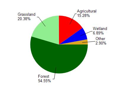
Stewart Lake is located in the Mill and Blue Mounds Creek watershed which is 186.74 mi². Land use in the watershed is primarily forest (54.60%), grassland (20.40%) and a mix of agricultural (15.30%) and other uses (9.80%). This watershed has 382.87 stream miles, 106.91 lake acres and 6,596.99 wetland acres.
Nonpoint Source Characteristics
This watershed is ranked Medium for runoff impacts on streams, Low for runoff impacts on lakes and High for runoff impacts on groundwater and therefore has an overall rank of High. This value can be used in ranking the watershed or individual waterbodies for grant funding under state and county programs.However, all waters are affected by diffuse pollutant sources regardless of initial water quality. Applications for specific runoff projects under state or county grant programs may be pursued. For more information, go to surface water program grants.
Stewart Lake is considered a Small under the state's Natural Community Determinations.
Natural communities (stream and lake natural communities) represent model results and DNR staff valiation processes that confirm or update predicted conditions based on flow and temperature modeling from historic and current landscape features and related variables. Predicated flow and temperatures for waters are associated predicated fish assemblages (communities). Biologists evaluate the model results against current survey data to determine if the modeled results are corect and whether biological indicators show water quaity degradation. This analysis is a core component of the state's resource management framework. Wisconsin's Riverine Natural Communities.
Small lake describes the size of small isolated waters. These variables affect the lakes response to watershed variables.