Columbia
No
No
No
Fish and Aquatic Life
Overview
Rocky Run is a popular trout stream in Columbia County that begins at Mud Lake and flows
to the Wisconsin River. From Highway 22 west to Highway 51 the stream is trout water and
six miles are Class II while another two miles are Class III. In warmer years, however, the
trout waters begin further downstream of Highway 22. A rare aquatic species has been found
in the creek in past surveys. Manure management and cattle access to the stream are
problems in the upper reaches below the Mud Lake State Wildlife Area. The creek has been
impounded on the upper end to create the Mud Lake State Wildlife Area. Portions of the
upper reach above Highway 22 have been ditched. There is also a private impoundment
above Highway 22 that warms the water. One to two miles of trout waters have been lost due
to increased water temperatures. There are not really any impacts on the trout section of the
stream although irrigation permits may cause a problem during periods of low flow.
Rocky Run receives point source discharges from Alliant/WI Power and Light and a tributary
to the stream receives discharge from the Rio wastewater treatment plant. The creek has been
ranked as a high priority for nonpoint source pollution and would benefit from a nonpoint
pollution reduction project.
Ripp, Coreen, Koperski, Cindy and Folstad, Jason. 2002. The State of the Lower Wisconsin River Basin.
PUBL WT-559-2002. Wisconsin Department of Natural Resources, Madison, WI.
Date 2002
Author Cynthia Koperski
Historical Description
Rocky Run is a popular trout stream in Columbia County. Six miles are Class II trout
waters while another two miles are Class III (WDNR, 1980). Manure management and
cattle access to the stream are problems in the upper reaches below the Mud Lake State
Wildlife Area (WDNR, 1991). Portions of the upper reach above STH 22 have been
ditched (Larson, 1992). There is also a private impoundment above STH 22 which
warms the water. One to two miles of trout waters have been lost due to increased
water temperatures (Larson, 1992).
Date 1994
Author Surface Water Inventory Of Wisconsin
Historical Description
Urban development on the south side of River Falls threatens water quality and the Class I
trout fishery in Rocky Run.
Date 1992
Author Surface Water Inventory Of Wisconsin
Historical Description
Rocky Run Creek T11N , R9E, Section 5, Surface Acres = 65.75, Miles = 21.7, Gradient = 6.22 feet per mile.
A long low-gradient stream which originates at Mud Lake and flows to the
Wisconsin River. The stream is unusual in that it originates in an open marsh and
has warm water for several miles before receiving sufficient spring flow and bank
cover to make conditions suitable for trout. After several miles the stream again
warms and warm water fishes persist downstream to the mouth. The stream is
stocked annually with brook and brown trout. Good parking and access is provided
by an abandoned portion of a county road ending at the stream. Portions of the stream
have been traversed by canoe. About 2,200 acres of wetland adjoin the stream.
From: Poff, Ronald J. and C.W. Threinen, 1965. Surface Water Resources of Columbia County:
Lake and Stream Classification Project. Wisconsin Conservation Department, Madison, WI.
Date 1965
Author Surface Water Inventory Of Wisconsin
General Condition
Rocky Run was assessed during the 2018 listing cycle; new biological (fish Index of Biotic Integrity (IBI) scores) sample data were clearly below the 2018 WisCALM listing thresholds for the Fish and Aquatic Life use. This water was meeting this designated use and was not considered impaired.
Date 2017
Author Ashley Beranek
Condition
Wisconsin has over 84,000 miles of streams, 15,000 lakes and milllions of acres of wetlands. Assessing the condition of this vast amount of water is challenging. The state's water monitoring program uses a media-based, cross-program approach to analyze water condition. An updated monitoring strategy (2015-2020) is now available. Compliance with Clean Water Act fishable, swimmable standards are located in the Executive Summary of Water Condition in 2018. See also the 'monitoring and projects' tab.
Reports
Recommendations
Monitor Water Quality or Sediment
Recommend not using 2009 data, stream and trib improvements were made, suggest monitoring water temperature. AU: 13519; ID: 10009943
Management Goals
Wisconsin's Water Quality Standards provide qualitative and quantitative goals for waters that are protective of Fishable, Swimmable conditions [Learn more]. Waters that do not meet water quality standards are considered impaired and restoration actions are planned and carried out until the water is once again fishable and swimmable
Management goals can include creation or implementation of a Total Maximum Daily Load analysis, a Nine Key Element Plan, or other restoration work, education and outreach and more. If specific recommendations exist for this water, they will be displayed below online.
Monitoring
Monitoring the condition of a river, stream, or lake includes gathering physical, chemical, biological, and habitat data. Comprehensive studies often gather all these parameters in great detail, while lighter assessment events will involve sampling physical, chemical and biological data such as macroinvertebrates. Aquatic macroinvertebrates and fish communities integrate watershed or catchment condition, providing great insight into overall ecosystem health. Chemical and habitat parameters tell researchers more about human induced problems including contaminated runoff, point source dischargers, or habitat issues that foster or limit the potential of aquatic communities to thrive in a given area. Wisconsin's Water Monitoring Strategy was recenty updated.
Grants and Management Projects
Monitoring Projects
| WBIC | Official Waterbody Name | Station ID | Station Name | Earliest Fieldwork Date | Latest Fieldwork Date | View Station | View Data |
|---|
|
|
Watershed Characteristics
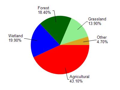
Rocky Run is located in the Duck Creek and Rocky Run watershed which is 140.89 mi². Land use in the watershed is primarily agricultural (43.10%), wetland (19.90%) and a mix of forest (18.40%) and other uses (18.60%). This watershed has 232.25 stream miles, 1,895.92 lake acres and 16,023.66 wetland acres.
Nonpoint Source Characteristics
This watershed is ranked Medium for runoff impacts on streams, Low for runoff impacts on lakes and High for runoff impacts on groundwater and therefore has an overall rank of High. This value can be used in ranking the watershed or individual waterbodies for grant funding under state and county programs.This water is ranked High Stream for individual Rivers based on runoff problems and the likelihood of success from project implementation.