Columbia
No
No
Yes
Fish and Aquatic Life
Overview
The North Branch of Duck Creek rises in northeastern Columbia County. Tributaries to the
stream have been extensively modified. The stream does not support a balanced sport fishery
and bank and adjacent farm field erosion are thought to be problems. Manure storage and
management are also an issue of concern. The North Branch Duck Creek receives point
source discharges from Del Monte Foods and the Cambria wastewater treatment plant. A
small impoundment has been constructed on the stream in Cambria to create Lake Tarrant.
Date 2002
Author Cynthia Koperski
Historical Description
The North Branch of Duck Creek rises in northeastern Columbia County. The stream is
considered full fish and aquatic life waters, but it doesn't support a balanced sport
fishery (WDNR, 1991). Bank and adjacent farm field erosion are thought to be the
problem. Manure storage and management are also a problem in the stream's drainage
(WDNR, 1991). Managment of process wastewater from a local canning facility
may be causing problems (WDNR, 1991, Heixn, 1992)
Date 1994
Author Surface Water Inventory Of Wisconsin
Historical Description
Duck Creek, North Branch T12N, R10E, Section 15, Surface Acres = 68.1, Miles = 23.4, Gradient = 7.1 feet per mile.
A meandering stream which originates above Tarrant Lake at Cambria
and receives numerous ditched tributaries along its course to the Wyocena Millpond.
Pollution is a continuing problem for this stream. It has reduced the fishery to one
of bullheads, carp, suckers and forage species which nearly every year experiences
pollution-caused mortalities. Access is possible from several town roads. About
2,427 acres of wetland adjoin the stream.
From: Poff, Ronald J. and C.W. Threinen, 1965. Surface Water Resources of Columbia County:
Lake and Stream Classification Project. Wisconsin Conservation Department, Madison, WI.
Date 1965
Author Surface Water Inventory Of Wisconsin
Impaired Waters
The 2018 assessments of the North Branch Duck Creek (miles 0-20.6) showed continued impairment by phosphorus; new total phosphorus sample data overwhelmingly exceeded the 2018 WisCALM listing criteria for the Fish and Aquatic Life use. However, available biological data did not indicate impairment (i.e. no macroinvertebrate or fish Index of Biotic Integrity (IBI) scored in the "poor" condition category). Based on the most updated information, no change in the existing impaired waters listing was needed.
Date 2017
Author Ashley Beranek
Impaired Waters
The North Branch of Duck Creek (1267500), from the mouth to Cambria, was placed on the impaired waters list in 2014 for total phosphorus. The 2016 assessments showed continued impairment by phosphorus; total phosphorus sample data overwhelmingly exceeded 2016 WisCALM listing thresholds for the Fish and Aquatic Life use, however, available biological data do not indicate impairment (i.e. no macroinvertebrate or fish Index of Biotic Integrity (IBI) scored in the "poor" condition category). Based on the most updated information, no change in existing impaired waters listing is needed.
Date 2015
Author Aaron Larson
Condition
Wisconsin has over 84,000 miles of streams, 15,000 lakes and milllions of acres of wetlands. Assessing the condition of this vast amount of water is challenging. The state's water monitoring program uses a media-based, cross-program approach to analyze water condition. An updated monitoring strategy (2015-2020) is now available. Compliance with Clean Water Act fishable, swimmable standards are located in the Executive Summary of Water Condition in 2018. See also the 'monitoring and projects' tab.
Reports
Recommendations
Restore Wetlands
Restore Wetlands
Management Goals
Wisconsin's Water Quality Standards provide qualitative and quantitative goals for waters that are protective of Fishable, Swimmable conditions [Learn more]. Waters that do not meet water quality standards are considered impaired and restoration actions are planned and carried out until the water is once again fishable and swimmable
Management goals can include creation or implementation of a Total Maximum Daily Load analysis, a Nine Key Element Plan, or other restoration work, education and outreach and more. If specific recommendations exist for this water, they will be displayed below online.
Monitoring
Monitoring the condition of a river, stream, or lake includes gathering physical, chemical, biological, and habitat data. Comprehensive studies often gather all these parameters in great detail, while lighter assessment events will involve sampling physical, chemical and biological data such as macroinvertebrates. Aquatic macroinvertebrates and fish communities integrate watershed or catchment condition, providing great insight into overall ecosystem health. Chemical and habitat parameters tell researchers more about human induced problems including contaminated runoff, point source dischargers, or habitat issues that foster or limit the potential of aquatic communities to thrive in a given area. Wisconsin's Water Monitoring Strategy was recenty updated.
Grants and Management Projects
Monitoring Projects
| WBIC | Official Waterbody Name | Station ID | Station Name | Earliest Fieldwork Date | Latest Fieldwork Date | View Station | View Data |
|---|
| 5591449 | Unnamed | 10041892 | Unnamed Open Water (WBIC 5591449) | 7/31/2012 | 7/31/2012 | Map | Data |
| 1267500 | North Branch Duck Creek | 10043580 | North Branch Duck Creek at Bush Rd | 1/1/2015 | 7/9/2025 | Map | Data |
| 1267500 | North Branch Duck Creek | 113009 | Duck Creek - Larsen Co Cambria Process 001 | 4/15/1977 | 4/15/1977 | Map | Data |
| 1267500 | North Branch Duck Creek | 113013 | Cambria Water Utility Wtp | | | Map | Data |
| 1267500 | North Branch Duck Creek | 10028843 | North Branch Duck Creek at East Bush Rd | 6/6/2008 | 1/1/2015 | Map | Data |
| 1267500 | North Branch Duck Creek | 113010 | Unnamed - Larsen Co Cambria Cooling 002 | | | Map | Data |
| 1267500 | North Branch Duck Creek | 10035701 | North Branch Duck Creek - Area of Open Water | 7/1/2010 | 7/17/2010 | Map | Data |
| 1267500 | North Branch Duck Creek | 10032671 | North Branch Duck Creek at Hwy. P Cambria | 1/1/2015 | 9/1/2016 | Map | Data |
| 1267500 | North Branch Duck Creek | 10046987 | N. Br. Duck Cr.-320 m dwnstrm of Tarrant Lake | 1/1/2015 | 1/1/2015 | Map | Data |
|
Watershed Characteristics
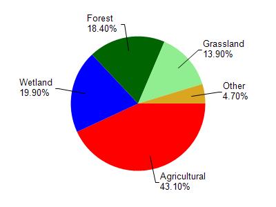
North Branch Duck Creek is located in the Duck Creek and Rocky Run watershed which is 140.89 mi². Land use in the watershed is primarily agricultural (43.10%), wetland (19.90%) and a mix of forest (18.40%) and other uses (18.60%). This watershed has 232.25 stream miles, 1,895.92 lake acres and 16,023.66 wetland acres.
Nonpoint Source Characteristics
This watershed is ranked Medium for runoff impacts on streams, Low for runoff impacts on lakes and High for runoff impacts on groundwater and therefore has an overall rank of High. This value can be used in ranking the watershed or individual waterbodies for grant funding under state and county programs.However, all waters are affected by diffuse pollutant sources regardless of initial water quality. Applications for specific runoff projects under state or county grant programs may be pursued. For more information, go to surface water program grants.