Sauk
No
No
Yes
Fish and Aquatic Life
Overview
Lake Delton is a 267-acre impoundment of Dell Creek. Much of its shoreline has been developed with summer homes, year-round homes and condominiums. The fishery of the lake is northern pike, walleye, largemouth bass, channel catfish and panfish.
The lake is eutrophic and has poor water quality, which is common to impoundments in southwest Wisconsin. Some of the water quality problems may be due to construction site erosion as well as rural nonpoint source pollution. The lake is experiencing increasing development pressure and may also experience problems as a result of urban stormwater runoff.
As a result of the development and the popularity of the lake for recreational and tourism purposes, the lake may also experience usage conflicts, particularly during the summer. Sewage pollution used to be a threat to the lake, but municipal sewer now serves residences
around the lake. The lake has nuisance aquatic weed growth that has required chemical treatment. Eurasian water milfoil has been found in the lake.
The Lake Delton Lake Association and the Village of Lake Delton contracted for a lake study and management plan to be developed for Lake Delton. The information collected and its analysis points to nonpoint sources of pollution in the Dell Creek watershed as being the primary sources of phosphorus loading to the lake.
Date 2002
Author Aquatic Biologist
Historical Description
Lake Delton is an impoundment of Dell Creek. Much of its shoreline has been developed with summer homes, year-round homes, and condominiums. The lake is eutrophic and has poor water quality (WDNR, 1991) which is common to impoundments in southwest Wisconsin. Some of the water quality problems may be due to construction site erosion as well as rural nonpoint source pollution (Bachhuber, 1992). The lake also has nuisance aquatic weed growth that has required chemical treatment (WDNR, 1991). Because of the development around the lake, usage conflicts may occur, particularly durring the summer. Residences around the lake are served by municipal sewer.
Date 1994
Author Surface Water Inventory Of Wisconsin
Historical Description
Source: 1971, Surface Water Resources of Sauk County Lake Delton, T13N, R6E, Sec. 15, 16, 21
A highly developed drainage lake created by a dam with a 20-foot head on Dell Creek in the northeastern corner of Sauk County. The watershed area of the lake totals 79.6 square miles and Dell Creek ranks number one as a trout stream in Sauk County. Largemouth bass, walleyes and panfish provide the major sport fishery. Northern pike, smallmouth bass, carp, and white suckers are also present. Lake Delton and the Dells area are an important tourist attraction for Wisconsin. Lake Delton is used extensively for fishing, pleasure boating, water skiing, and swimming during the summer months. Ice fishing and snowmobiling are popular activities on the lake in the winter. Game assets are limited due to the population density of the area, but puddle ducks are frequently seen during the spring and fall migratory periods. Sewage pollution from the many cottages and resorts has been a major problem in the past and is still a potential source today. Extension of sewerage in this area is in progress. Public access is available from two boat launching sites, one town park and one bridge crossing. Four boat rentals and two private campgrounds are located nearby.
Surface area = 266.88 acres, S.D.F. = 2.92, Maximum depth = 16 feet.
Date 1971
Author Surface Water Inventory Of Wisconsin
Impaired Waters
Delton Lake (WBIC 1295400) was placed on the impaired waters list for total phosphorus in 2016. The 2018 assessments showed continued impairment by phosphorus; total phosphorus sample data was overwhelmingly exceeded the 2018 WisCALM listing thresholds for the Recreation use and Fish and Aquatic Life use. Chlorophyll-a sample data exceeded the REC and FAL use thresholds. Based on the most updated information the impairments of Excess Algal Growth and Eutrophication were added to the Total Phosphorus listing.
Date 2017
Author Ashley Beranek
Impaired Waters
Delton Lake (1295400) was assessed during the 2016 listing cycle; total phosphorus sample data overwhelmingly exceeded 2016 WisCALM listing thresholds for the Recreation use; however chlorophyll data did not exceed REC thresholds. Total phosphorus and chlorophyll data did not exceed Fish and Aquatic Life thresholds.
Date 2015
Author Aaron Larson
Condition
Wisconsin has over 84,000 miles of streams, 15,000 lakes and milllions of acres of wetlands. Assessing the condition of this vast amount of water is challenging. The state's water monitoring program uses a media-based, cross-program approach to analyze water condition. An updated monitoring strategy (2015-2020) is now available. Compliance with Clean Water Act fishable, swimmable standards are located in the Executive Summary of Water Condition in 2018. See also the 'monitoring and projects' tab.
Reports
Recommendations
Informational Meetings
Aquatic Plant Monitoring or Survey
summer plant survey will be conducted, voucher specimens of plant species present will be preserved,
Aquatic Plant Management Plan
Update
Project Deliverable
. Final recommendations will be presented in the plan, and the plan will be made available at the local library and presented at an organized public lake meeting.
Management Goals
Wisconsin's Water Quality Standards provide qualitative and quantitative goals for waters that are protective of Fishable, Swimmable conditions [Learn more]. Waters that do not meet water quality standards are considered impaired and restoration actions are planned and carried out until the water is once again fishable and swimmable
Management goals can include creation or implementation of a Total Maximum Daily Load analysis, a Nine Key Element Plan, or other restoration work, education and outreach and more. If specific recommendations exist for this water, they will be displayed below online.
Monitoring
Monitoring the condition of a river, stream, or lake includes gathering physical, chemical, biological, and habitat data. Comprehensive studies often gather all these parameters in great detail, while lighter assessment events will involve sampling physical, chemical and biological data such as macroinvertebrates. Aquatic macroinvertebrates and fish communities integrate watershed or catchment condition, providing great insight into overall ecosystem health. Chemical and habitat parameters tell researchers more about human induced problems including contaminated runoff, point source dischargers, or habitat issues that foster or limit the potential of aquatic communities to thrive in a given area. Wisconsin's Water Monitoring Strategy was recenty updated.
Grants and Management Projects
Monitoring Projects
| WBIC | Official Waterbody Name | Station ID | Station Name | Earliest Fieldwork Date | Latest Fieldwork Date | View Station | View Data |
|---|
| 1295400 | Delton Lake | 10033914 | Delton Lake Public Beach | 8/11/2005 | 9/4/2015 | Map | Data |
| 1295400 | Delton Lake | 573055 | Lake Delton - Center of Lake | 6/12/1980 | 10/9/2023 | Map | Data |
| 1295400 | Delton Lake | 10040775 | Boat Landing on E Hiawatha Dr. | 7/17/2013 | 7/17/2013 | Map | Data |
| 1295400 | Delton Lake | 10017457 | Lake Delton -- Ramp | 7/18/2005 | 6/27/2016 | Map | Data |
| 1295400 | Delton Lake | 10019402 | Lake Delton -- Access Nr County Rd A | 8/31/2005 | 9/30/2013 | Map | Data |
| 1295400 | Delton Lake | 10005446 | Lake Delton | 7/1/1994 | 7/26/2018 | Map | Data |
| 1295400 | Delton Lake | 573180 | Lake Delton at Spring Brook Creek | 8/14/1995 | 7/16/2012 | Map | Data |
| 1295400 | Delton Lake | 573179 | Lake Delton - Trib at Swimming Beach | 5/15/1996 | 7/16/2012 | Map | Data |
| 1295400 | Delton Lake | 573182 | Lake Delton - Outlet | 6/27/1989 | 7/17/2003 | Map | Data |
| 1295400 | Delton Lake | 10040774 | Delton Lake - Co Hwy A public fishing pier | 7/17/2013 | 7/17/2013 | Map | Data |
| 1295400 | Delton Lake | 10051713 | Township 1337 | 6/21/2019 | 6/21/2019 | Map | Data |
| 1295400 | Delton Lake | 10014879 | Lake Delton-Boom Shock Entire Shore | | | Map | Data |
|
Watershed Characteristics
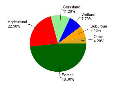
Delton Lake is located in the Dell Creek watershed which is 133.73 mi². Land use in the watershed is primarily forest (48.30%), agricultural (22.50%) and a mix of grassland (11.20%) and other uses (18.00%). This watershed has 231.97 stream miles, 193.10 lake acres and 4,715.88 wetland acres.
Nonpoint Source Characteristics
This watershed is ranked High for runoff impacts on streams, Medium for runoff impacts on lakes and High for runoff impacts on groundwater and therefore has an overall rank of High. This value can be used in ranking the watershed or individual waterbodies for grant funding under state and county programs.However, all waters are affected by diffuse pollutant sources regardless of initial water quality. Applications for specific runoff projects under state or county grant programs may be pursued. For more information, go to surface water program grants.