Monroe
No
No
Yes
Fish and Aquatic Life
Overview
Lake Tomah is a 225-acre impoundment of the South Fork of the Lemonweir River located in
the City of Tomah. The average depth is around four feet and a city park with a boat landing
is found along the eastern shore of the lake. The dam impounding the lake was severely
damaged by flooding in the summer of 1990. The lake was subsequently drawn down, the
dam repaired and the lake dredged. Lake Tomah was then refilled in 1993. A 2000 fish survey
documented crappie, bluegill, largemouth bass, northern pike, walleye, and carp. Aquatic
plant surveys documented a healthy aquatic plant community in 1994, however a severe
decline in the aquatic plant population was discovered in 1999. The lack of water clarity was
noted as a likely cause for the decline in plants. This water column turbidity may be caused by
suspension of silt by carp, algae blooms, or both. Since the aquatic plant community in Lake
Tomah wasn't extensive after the lake was dredged, the documented decline has alarmed
fisheries managers. Aquatic plants serve as nurseries for young fish, nesting and spawning
sites for some fish. These plants also reduce bank erosion by damping wave action and
remove nutrients that would otherwise be available for algae blooms. An effort to reduce the
carp population of Lake Tomah would help improve water quality conditions in the lake.
Nutrients entering Lake Tomah have contributed to nuisance algae blooms resulting in pH
levels above 9, which exceeds the water quality standard for pH. Consequently, Lake Tomah
is classified as an impaired water. A volunteer self-help lake monitor has been trained to
collect data on Lake Tomah. These self-help monitoring activities should continue on Lake
Tomah.
In 1990, the WDNR selected Lake Tomah and its watershed as a priority watershed project
under the Wisconsin Nonpoint Source Water Pollution Abatement Program. Successful
implementation of the watershed plan would reduce sediment and nutrient delivery to Lake
Tomah. Since 1992, the Monroe County Land Conservation Department has worked with
landowners in the Lake Tomah Watershed to reduce an estimated 2,300 tons per year of
sediment from reaching the lake. A reduction of 1,600 pounds per year of phosphorus has also
been estimated. These reductions of pollutants are all due to conservation practices put in
place within the Lake Tomah Watershed. This project is slated for completion in 2002.
Since lake dredging is an expensive undertaking, reduction of upstream sources of sediments
are a cost effective option to prolong the life of an impoundment. The Lake Tomah Priority
Watershed Project has been successful in accomplishing reductions in upstream sediment
sources. In addition, a sediment trap was installed on the upper end of Lake Tomah where the
South Fork of the Lemonweir River enters the lake. The City of Tomah is responsible for
tracking the filling of this sediment trap and dredging it periodically when filled.
Date 2002
Author Aquatic Biologist
Historical Description
WDNR in cooperation with the city of Tomah and the Lalte Tomah Protection and
Rehabilitation District, completed a comprehensive lake management plan in 1989. The
plan provides technical and administrative structure to protect and rehabilitate Lake
Tomah. The lake restoration effort includes the following components: lake deepening,
fish restocking, fish habitat inlprovement, nonpoint source pollution control, lake
protection and funding development.
The Lake Tomah Protection and Rehabilitation District is currently implementing the
lake management plan. WDNR selected tke Lake Tomah watershed as a priority lake
project under the Wisconsin Nonpoint Source Water Pollution Abatement Program in
1990. A Nonpoint Source Control Plan For the Lake Tomah Priority Lake Project was
completed in mid-1992 and should receive final approval by late 1992. The successful
implementation of the watershed plan should minimize sediment delivery to the lake. An
extensive lake dredging project designed to restore lake depth and aquatic habitat was
initiated in late 1991 and is scheduled for completion in early 1992.
The dam impounding the lake was severely damaged by flooding in the summer of 1990.
Construction of a new dam will be completed by early 1993. Restoration of the fishery is
scheduled to begin in the spring of 1993.
Date 1994
Author Surface Water Inventory Of Wisconsin
Historical Description
Source: 1969, Surface Water Resources of Monroe County Lake Tomah, T17N, R1W, S5
This medium hard water, recreational drainage impoundment is located on South Fork of the Lemonweir River (Lemonweir Creek). The dam has a head of 11 feet and is owned by the City of Tomah. The water is alkaline, has a low transparency, and at the time of the investigation, the water was turbid. Northern pike, largemouth bass, perch, bluegill, pumpkinseed and crappie are the primary sport fish. Occasional partial winterkills have occurred in the past. Due to heavy growths of aquatic vegetation, chemical weed control has been carried on. There is one resort, one motel, 26 dwellings and two public park areas. There is boat launching with parking. Muskrat numbers are significant in the biota. Teal, mallard, and wood duck nesting takes place and migrating waterfowl use the flowag
Surface Water Acres = 225, S.D.F. = 1.78, Maximum Depth = 19 feet
Date 1969
Author Surface Water Inventory Of Wisconsin
Impaired Waters
Tomah Lake (WBIC 1342100) was placed on the impaired waters list for total phosphorus in 1998. The 2018 assessments showed continued impairment by phosphorus; new total phosphorus and chlorophyll-a sample data exceeded the 2018 WisCALM listing thresholds for the Recreation use and Fish and Aquatic Life use. Based on the most updated information, no change in the existing impaired waters listing was needed.
Date 2017
Author Ashley Beranek
Impaired Waters
Tomah Lake (1342100) was placed on the impaired waters list for total phosphorus in 1998. The 2016 assessments showed continued impairment by phosphorus; total phosphorus sample data overwhelmingly exceeded 2016 WisCALM listing thresholds for the Recreation use and Fish and Aquatic Life use, and chlorophyll data exceeded only REC thresholds. This water was also assessed for chlorides and sample data did not exceed 2016 WisCALM chronic and acute listing criteria for the Fish and Aquatic Life use. Based on the most updated information, no change in existing impaired waters listing is needed.
Date 2015
Author Aaron Larson
Condition
Wisconsin has over 84,000 miles of streams, 15,000 lakes and milllions of acres of wetlands. Assessing the condition of this vast amount of water is challenging. The state's water monitoring program uses a media-based, cross-program approach to analyze water condition. An updated monitoring strategy (2015-2020) is now available. Compliance with Clean Water Act fishable, swimmable standards are located in the Executive Summary of Water Condition in 2018. See also the 'monitoring and projects' tab.
Reports
Recommendations
Shoreland Ordinance
Monroe County proposes to amend or create a shoreland zoning ordinance that complies with the requirements of NR 115, Wisconsin Administrative Code (as revised effective February 1, 2010) and retain existing regulations that exceed the water resource protections of NR 115 or are specific or unique to local needs.
Train Volunteers to Do Watercraft Inspections
Monitor Invasive Species
Habitat Restoration - Lake
The City of Tomah proposes to restore aquatic and fisheries habitat in Lake Tomah in Monroe County. Major project elements to include tree drops, placement of rip rap, establishment of rock bars and revegetation of disturbed areas and islands.
Habitat Restoration - Lake
Install Kiosk or Sign
Map Depth of Lake (Bathymetry)
Monitor Water Quality or Sediment
Determine water quality in each sub-basin from ground water seepage
Informational Meetings
Issue News/Media Release
Disseminate information to the public by local newspaper about dam plans.
Dam Safety or Removal
Analysis and design of modifications to the Lake Tomah spillway, outlet structure, and earthen embankment. 2) Develop an emergency action plan.3) Develop a dam operation and maintenance plan
Carp Removal
Removed Carp on Lake Tomah
Nine Key Element Plan
Lake Tomah PWS Plan - Nine Key Element Plan - The Lake Tomah Priority Watershed Project plan assesses the nonpoint sources of pollution in the Lake Tomah Watershed and guides the implementation of nonpoint source control measures. These control measures are needed to meet specific water resource objectives for Lake Tomah and its tributaries. The purpose of this project is to reduce the amount of pollutants originating from nonpoint sources that reach surface water and groundwater within the Lake Tomah Priority Watershed Project area.
Standards Details
Lake Tomah has been a valued recreational resource for the community of Tomah since the lake was created in 1938 and 1939. The lake and surrounding shoreline is used by community residents for fishing, boating, hunting, picnicking, and many other outdoor recreational activities. Lake Tomah is used by many area residents. Over 80 percent of the city residents completing a lake assessment survey in October 2007 indicated they visit or use the lake one or more times per year. The majority of the residents value the lake as a recreational resource.
The most recent effort to improve Lake Tomah was in 1992 and 1993 when the lake was dredged and a new dam was built. Carp became abundant in the lake after the dredging and are a major contributor to the poor lake conditions which exist today. The carp degrade lake habitat by preventing the growth of aquatic plants, degrade water quality and dominate the fishery. Excessive runoff of nutrients from agricultural lands and urban areas which drain to Lake Tomah also contribute significantly to poor water quality. The degraded environmental conditions in the lake limit recreational use and the fishery. Most residents of Tomah feel the lake will worsen or remain the same if improvement actions are not taken.
This Lake Tomah Management Plan has been developed by Lake Tomah Lake Committee (community members appointed by the mayor and approved by City Council) working in partnership with community residents, the Monroe County Land Conservation Department staff and staff from the Wisconsin Department of Natural Resources. This plan outlines a framework of lake stewardship activities which will provide improved motorized and non-motorized recreational opportunities (including both motorized and non-motorized activities), fish and aquatic life habitats, and water clarity. This lake plan includes clearly defined goals and activities that will be the road map to improve the attributes of Lake Tomah that are valued by the residents of the community. Estimated costs and project lead agency for different management activities are shown Appendix A.
Date 2008
Author Aquatic Biologist
Management Goals
Wisconsin's Water Quality Standards provide qualitative and quantitative goals for waters that are protective of Fishable, Swimmable conditions [Learn more]. Waters that do not meet water quality standards are considered impaired and restoration actions are planned and carried out until the water is once again fishable and swimmable
Management goals can include creation or implementation of a Total Maximum Daily Load analysis, a Nine Key Element Plan, or other restoration work, education and outreach and more. If specific recommendations exist for this water, they will be displayed below online.
Monitoring
Monitoring the condition of a river, stream, or lake includes gathering physical, chemical, biological, and habitat data. Comprehensive studies often gather all these parameters in great detail, while lighter assessment events will involve sampling physical, chemical and biological data such as macroinvertebrates. Aquatic macroinvertebrates and fish communities integrate watershed or catchment condition, providing great insight into overall ecosystem health. Chemical and habitat parameters tell researchers more about human induced problems including contaminated runoff, point source dischargers, or habitat issues that foster or limit the potential of aquatic communities to thrive in a given area. Wisconsin's Water Monitoring Strategy was recenty updated.
Grants and Management Projects
Monitoring Projects
| WBIC | Official Waterbody Name | Station ID | Station Name | Earliest Fieldwork Date | Latest Fieldwork Date | View Station | View Data |
|---|
| 1338500 | South Fork Lemonweir River | 423125 | Lemonweir Creek South Fork - Lemon Weir Creek | 7/24/1973 | 2/13/1975 | Map | Data |
| 1342100 | Lake Tomah | 10004111 | Lake Tomah | 6/30/1994 | 4/3/2017 | Map | Data |
| 1342100 | Lake Tomah | 423223 | Lake Tomah -- Winnebago Park - North Boat Ramp | 7/13/2004 | 8/7/2013 | Map | Data |
| 1342100 | Lake Tomah | 423126 | Lake Tomah - Deep Hole | 7/24/1973 | 8/13/2023 | Map | Data |
| 1342100 | Lake Tomah | 10017648 | Lake Tomah -- Winnebago Park - South Boat Ramp | 2/2/2024 | 2/2/2024 | Map | Data |
| 1342100 | Lake Tomah | 423231 | Lake Tomah at Juneau St | 7/17/1991 | 7/17/1991 | Map | Data |
| 1342100 | Lake Tomah | 10030925 | Lake Tomah -- Bow St Boat Ramp | 2/2/2024 | 2/2/2024 | Map | Data |
| 1342100 | Lake Tomah | 10017438 | Lake Tomah -- Juneau St Access | | | Map | Data |
|
Watershed Characteristics
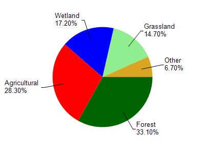
Lake Tomah is located in the Little Lemonweir River watershed which is 218.01 mi². Land use in the watershed is primarily forest (33.10%), agricultural (28.30%) and a mix of wetland (17.20%) and other uses (21.40%). This watershed has 488.22 stream miles, 1,656.86 lake acres and 18,277.64 wetland acres.
Nonpoint Source Characteristics
This watershed is ranked Not Ranked for runoff impacts on streams, Low for runoff impacts on lakes and High for runoff impacts on groundwater and therefore has an overall rank of High. This value can be used in ranking the watershed or individual waterbodies for grant funding under state and county programs.However, all waters are affected by diffuse pollutant sources regardless of initial water quality. Applications for specific runoff projects under state or county grant programs may be pursued. For more information, go to surface water program grants.