Green
Yes
Yes
No
Fish and Aquatic Life
Overview
From: Poff, Ronald J., and C.W. Threinen, Lake and Stream Classification Project. Surface Water Resources of Green County, Wisconsin Conservation Department, Madison I, 1961.
Story Creek is a spring-fed tributary to the Sugar River originating in south central Dane County and joining the Sugar River in Green County. A great deal of the stream runs through the Brooklyn State Wildlife Area. Streambank erosion and beaver dams near the stream’s headwaters have impacted the trout habitat in the upper portion (Surface Waters of Dane Co.). The lower 6.6 miles is managed as a Class II trout fishery, classified as an ERW, and is considered one of the best trout streams in Green County (Water Resources of Green County). Additionally, some warm water species such as northern pike and panfish are found in some of the ditched sections (Surface Waters of Dane Co.).
The entire stream has been impacted by agricultural runoff and is likely achieving its highest potential use (Bush, pers comm). Two major trout stamp projects have been done in recent years to rehabilitate three-quarters of a mile of stream. Fish and habitat surveys conducted in the last several years show the stream supports both reproducing populations of brook and brown trout as well as cool water forage species.
Date
Author Aquatic Biologist
Overview
Story Creek is a spring-fed tributary to the Sugar River originating in south central Dane County and joining the Sugar River in Green County. A great deal of the stream runs through the Brooklyn State Wildlife Area. Streambank erosion and beaver dams near the stream’s headwaters have impacted the trout habitat in the upper portion (WDNR, 1985). The lower 6.6 miles is managed as a Class II trout fishery, classified as an ERW, and is considered one of the best trout streams in Green County (WDNR, 1980a). Additionally, some warm water species such as northern pike and panfish are found in some of the ditched sections (WDNR, 1985).
The entire stream has been impacted by agricultural runoff and is likely achieving its highest potential use (Bush, 2001). Two major trout stamp projects have been done in recent years to rehabilitate three-quarters of a mile of stream. Fish and habitat surveys conducted in the last several years show the stream supports both reproducing populations of brook and brown trout as well as cool water forage species.
Date 2002
Author Aquatic Biologist
Historical Description
Story Creek (Tipperary Creek) -T5N, R8E, Sec. 36, Surface acres = 6.5, Length =3 miles, Stream order = II, Gradient = 8.7 ft/mile, Base discharge = 8.9 cfs. (7.5 stream miles total including portion in Green County)
Story Creek is a sprlng-fed tributary to the Sugar River originatlng in south central Dane County and
joining the Sugar River in Green County near Dayton. It is located within the Brooklyn Wildlife Area and drains 27 square miles (Dane and Green Counties) of agricultural and marsh lands. Much of the agricultural land has been created by draining these peat marshes and ditching the creek. One effect of these alterations is a lowering of the water table and a resultant reduction in stream flow (Dane Cty. Reg. Plann. Comm. 1979a). Stream bank erosion is a significant problem and beaver dams near the creek's headwaters have ruined most of the trout habitat in the upper part of the stream. Despite these problems Story Creek is a Class II trout stream. Most of the stream is located in Green County. Its 12 feeder springs keep the waters cool and the substrate composition in some portions is favorable spawning habitat for brown trout. In addition, both brook and brown trout are stocked. Northern pike are common in the ditched stretches, along with diverse groupings of panflsh and forage fish.
Story Creek is not affected by any industrial or municipal wastes, and its waters are of good quality. Agricultural runoff and stream bank erosion are the only significant causes of pollution (Dane Cty.Reg. Plann. Comm. 1979a). Public access to the creek is good within the Brooklyn Wildlife Area. Its recreational value is high owing to its wildlife resources, that include pheasant, duck, quail, deer, rabbit, woodcock, and squirrel. The Brooklyn Wildlife AreaiIs one of the most popular hunting sites in Dane County.
The channelized portions have little aesthetic value. The stream has the potential to produce more wild trout. Fish species: American brook lamprey, brown. brook. and rainbow trout, central mudminnow, central stoneroller, redside dace, fathead minnow, blacknose dace, creek chub, white sucker, golden and shorthead redhorse, brook stickleback, green sunfish, rainbow, Iowa, fantail and johnny darter, mottled sculpin. and northern pike.
From: Day, Elizabeth A.; Grzebieniak, Gayle P.; Osterby, Kurt M.; and Brynildson, Clifford L., 1985. Lake and Stream Classification Project. Surface Water Resources of Dane County, Wisconsin Department of Natural Resources, Madison, WI.
Date 1985
Author Surface Water Inventory Of Wisconsin
Historical Description
Flows south along the town line and southwest into the Sugar River. Managed for brown trout; however, smallmouth bass are common. Much clear deep water with sand and gravel bottoms; silt at a minimum. Accessible through public hunting grounds. Rainbow trout are planted here annually. One hundred and twenty-five acres of predominantly open marsh lies contiguous with the stream. From: Poff, Ronald J., and C.W. Threinen, Lake and Stream Classification Project. Surface Water Resources of Green County, Wisconsin Conservation Department, Madison I, 1961.Surface Acres= 10.9, Miles= 4.5, Gradient- 17.8' per mile
Date 1961
Author Surface Water Inventory Of Wisconsin
General Condition
Story Creek [Tipperary] (Mile 0 to 12.54) was assessed during the 2018 listing cycle; new biological (fish Index of Biotic Integrity (IBI) scores) and temperature sample data were clearly below the 2018 WisCALM listing thresholds for the Fish and Aquatic Life use. This water was meeting this designated use and was not considered impaired.
Date 2017
Author Ashley Beranek
Condition
Wisconsin has over 84,000 miles of streams, 15,000 lakes and milllions of acres of wetlands. Assessing the condition of this vast amount of water is challenging. The state's water monitoring program uses a media-based, cross-program approach to analyze water condition. An updated monitoring strategy (2015-2020) is now available. Compliance with Clean Water Act fishable, swimmable standards are located in the Executive Summary of Water Condition in 2018. See also the 'monitoring and projects' tab.
Reports
Recommendations
Citizen-Based Stream Monitoring
Collect chemical, physical, and/or biological water quality data to assess the current overall stream health. The data can inform management decisions and may be used to identify impaired waters for biennial lists.
Management Goals
Wisconsin's Water Quality Standards provide qualitative and quantitative goals for waters that are protective of Fishable, Swimmable conditions [Learn more]. Waters that do not meet water quality standards are considered impaired and restoration actions are planned and carried out until the water is once again fishable and swimmable
Management goals can include creation or implementation of a Total Maximum Daily Load analysis, a Nine Key Element Plan, or other restoration work, education and outreach and more. If specific recommendations exist for this water, they will be displayed below online.
Monitoring
Monitoring the condition of a river, stream, or lake includes gathering physical, chemical, biological, and habitat data. Comprehensive studies often gather all these parameters in great detail, while lighter assessment events will involve sampling physical, chemical and biological data such as macroinvertebrates. Aquatic macroinvertebrates and fish communities integrate watershed or catchment condition, providing great insight into overall ecosystem health. Chemical and habitat parameters tell researchers more about human induced problems including contaminated runoff, point source dischargers, or habitat issues that foster or limit the potential of aquatic communities to thrive in a given area. Wisconsin's Water Monitoring Strategy was recenty updated.
Grants and Management Projects
Monitoring Projects
| WBIC | Official Waterbody Name | Station ID | Station Name | Earliest Fieldwork Date | Latest Fieldwork Date | View Station | View Data |
|---|
| 885400 | Story Creek | 10010519 | Story Creek | | | Map | Data |
| 885400 | Story Creek | 10009948 | Story Creek Near Hwy X | 11/14/2002 | 5/19/2026 | Map | Data |
| 885400 | Story Creek | 10013337 | Story Creek Hwy X Bridge | 11/27/2019 | 4/21/2021 | Map | Data |
| 885400 | Story Creek | 10010910 | Story Creek At Sth 92 | 10/7/2010 | 5/19/2026 | Map | Data |
| 885400 | Story Creek | 10044534 | Story Creek in Brooklyn Wildlife Area | 1/1/2015 | 5/31/2018 | Map | Data |
| 885400 | Story Creek | 10009467 | Story Creek Upstream Cty X | 1/1/2015 | 1/1/2015 | Map | Data |
| 885400 | Story Creek | 10013334 | Story Creek | | | Map | Data |
| 885400 | Story Creek | 10009360 | Story Creek Habitat And Fish Survey (at Cth X) | 8/18/2011 | 8/18/2011 | Map | Data |
|
Watershed Characteristics
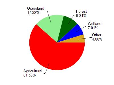
Story Creek is located in the Allen Creek and Middle Sugar River watershed which is 154.01 mi². Land use in the watershed is primarily agricultural (61.50%), grassland (17.30%) and a mix of forest (9.30%) and other uses (11.80%). This watershed has 263.25 stream miles, 96.10 lake acres and 5,963.23 wetland acres.
Nonpoint Source Characteristics
This watershed is ranked Medium for runoff impacts on streams, Not Ranked for runoff impacts on lakes and High for runoff impacts on groundwater and therefore has an overall rank of High. This value can be used in ranking the watershed or individual waterbodies for grant funding under state and county programs.However, all waters are affected by diffuse pollutant sources regardless of initial water quality. Applications for specific runoff projects under state or county grant programs may be pursued. For more information, go to surface water program grants.