Green
Yes
Yes
No
Fish and Aquatic Life
Overview
The river for which this watershed is named begins in southern Dane County and runs 28 miles before merging with the Sugar River at the Albany Millpond. Although warm water forage species dominate the lower 19 miles from the mouth up to the Sugar River State Trail, this portion of the river is managed as a warm water sport fishery. Gamefish and panfish, while not abundant, are present in this stretch of the river (Surface Waters of Green Co.). Approximately 1,200 acres of wetlands adjoin the lower portion of the river as part of the Albany State Wildlife Area, which provides valuable habitat for wildlife, buffers the stream and provides other important wetland functional values.
Six miles of river above New Glarus, a stretch commonly known as the New Glarus Branch, is managed as a Class II trout stream and is classified as an ERW. Brown trout are stocked in this section of stream wherever the habitat is suitable (Bush, pers comm).
The New Glarus wastewater treatment facility discharges to this river. In year, the village built a new facility in order to eliminate problems caused by its previous aging plant. The new facility has not had problems meeting its Wisconsin Pollution Discharge Elimination System (WPDES) permit limits. In summer of 2002, a fish kill occurred on a small section of stream in New Glarus due to chlorine to disinfection of the village’s new waterlines. Approximately 200 fish were killed including a dozen brown trout.
A 2002 fish and habitat survey conducted above New Glarus showed various year classes of brown trout and cold water forage species, but overall the stream lacks good habitat. The fishery may respond favorably to habitat work and reduction in sediment load to the stream.
Date 2002
Author Aquatic Biologist
Historical Description
Sugar River (New Glarus Branch) -T5N, R7E, Sec. 32, Surface acres = 1.5, Length = 2 miles, Stream order = I, Gradient = 7.5 ft/mile, Base discharge = 1.6 cfs.
The Little Sugar River is a small spring-fed stream originating in southwestern Dane County and flowing south to the Sugar River in Green County. Pastured land dominates the watershed. The stream bottom is gravel, sand, and silt. Many species of aquatic plants are found in the stream including arrowhead, flat-leaved pondweed, Elodea sp., watercress, speedwell, and bulrush. Water quality is good in Dane County, though overgrazing and streambank erosion are problems. It is managed as a Class III trout stream. Good populations of forage fish are present. Access is provided by one road crossing in the county.
Fish species: redside dace, fathead minnow, creek chub, white sucker, mottled sculpin, and brown trout.
From: Day Elizabeth A.; Grzebieniak, Gayle P.; Osterby, Kurt M.; and Brynildson, Clifford L., 1985. Lake and Stream Classification Project. Surface Water Resources of Dane County, Wisconsin Department of Natural Resources, Madison, WI
Date 1985
Author Surface Water Inventory Of Wisconsin
Historical Description
Beginning in southern Dane County, the Little Sugar River runs through New Glarus and becomes quite large before it merges with the Sugar River at the Albany Millpond. The watershed consists mainly of cropland, pasture and hardwood forest, although the lower end of the river flows through a sizable wetlands area. Bank erosion is heavy in some of the pastured areas, and several stretches have been ditched. Silt and muck are the primary bottom types although gravel runs are common above New Glarus. In Green County, a total of two unnamed and eight named streams enter the Little Sugar River, of which three (Hammerly Creek, Ward Creek and the Little Sugar River west Branch) are trout streams.
The entire stream above Section 24 (locally referred to as New Glarus Branch) is managed as Class II trout water, although there is very little natural reproduction below New Glarus. Current management is for brown trout although rainbow trout were stocked prior to 1960. r"1anagement below New Glarus is for warm water species with the fishery being dominated by forage species. Gamefish and panfish are not abundant, but those found include --brown trout, northern pike," catfish, smallmouth bass, green sunfish and black bullheads. The redside dace, a special concern species in Wisconsin, is also present.
Approximately 1,150 acres of wetlands adjoin the stream and provide a valuable habitat for muskrats, migratory waterfowl and other wildlife. Over 1,100 acres of state owned land in this area are part of the Albany Wildlife Area and furnish 17 miles of public frontage on the Little Sugar River. Fourteen public road bridges span the river, of which four above New Glarus provide the only public frontage on the trout waters. Additional public access is available in places from 14 miles of the Sugar River State Trail which parallels the river between New Glarus and Albany, and navigable water access can be achieved from Albany Millpond.
Fish Species: Brown trout, central mudminnow, northern pike, redside dace, spotfin shiner, sand shiner, bluntnose ~innow, fathead minnow, bullhead minnow, creek chub, quillback, white sucker, northern hog sucker, silver redhorse, shorthead redhorse, black bullhead, channel catfish, brook stickleback, green sunfish, smallmouth bass, Johnny darter, blackside darter, mottled sculpin. Surface Acres = 57.6, Length = 24.0 miles, Gradient = 2.2 ft./mi., Base Discharqe = 79.0 cu.
Bush, D.M., R. Cornelius, D. Engle, and C.L. Brynildson. 1980. Lake and Stream Classification Project. Surface Water Resources of Green County, 2nd Edition. Wisconsin Department of Natural Resources, Madison, Wisconsin.
Date 1980
Author Surface Water Inventory Of Wisconsin
Impaired Waters
The 2018 assessments of the Little Sugar River (miles 0-19) showed continued impairment by phosphorus; new total phosphorus sample data exceeded 2018 WisCALM listing criteria for the Fish and Aquatic Life use, however, available biological data did not indicate impairment (i.e. no macroinvertebrate or fish Index of Biotic Integrity (IBI) scored in the "poor" condition category). Based on the most updated information, no change in existing impaired waters listing is needed.
Date 2017
Author Ashley Beranek
Impaired Waters
Little Sugar River (880100), from the mouth to Ward Creek, was placed on the impaired waters list for total phosphorus in 2012. The 2016 assessments showed continued impairment by phosphorus; total phosphorus sample data exceeded 2016 WisCALM listing criteria for the Fish and Aquatic Life use, however, available biological data did not indicate impairment (i.e. no macroinvertebrate or fish Index of Biotic Integrity (IBI) scored in the "poor" condition category). Based on the most updated information, no change in existing impaired waters listing is needed.
Date 2015
Author Aaron Larson
Condition
Wisconsin has over 84,000 miles of streams, 15,000 lakes and milllions of acres of wetlands. Assessing the condition of this vast amount of water is challenging. The state's water monitoring program uses a media-based, cross-program approach to analyze water condition. An updated monitoring strategy (2015-2020) is now available. Compliance with Clean Water Act fishable, swimmable standards are located in the Executive Summary of Water Condition in 2018. See also the 'monitoring and projects' tab.
Reports
Recommendations
Restore Wetlands
Restore Wetlands
Restore Wetlands
Restore Wetlands
Restore Wetlands
Restore Wetlands
Restore Wetlands
Restore Wetlands
Restore Hydrology, Morphology
Evaluate potential stream improvement project for channelized areas of the Little Sugar River. In progress through landowners and NRCS project.
Management Goals
Wisconsin's Water Quality Standards provide qualitative and quantitative goals for waters that are protective of Fishable, Swimmable conditions [Learn more]. Waters that do not meet water quality standards are considered impaired and restoration actions are planned and carried out until the water is once again fishable and swimmable
Management goals can include creation or implementation of a Total Maximum Daily Load analysis, a Nine Key Element Plan, or other restoration work, education and outreach and more. If specific recommendations exist for this water, they will be displayed below online.
Monitoring
Monitoring the condition of a river, stream, or lake includes gathering physical, chemical, biological, and habitat data. Comprehensive studies often gather all these parameters in great detail, while lighter assessment events will involve sampling physical, chemical and biological data such as macroinvertebrates. Aquatic macroinvertebrates and fish communities integrate watershed or catchment condition, providing great insight into overall ecosystem health. Chemical and habitat parameters tell researchers more about human induced problems including contaminated runoff, point source dischargers, or habitat issues that foster or limit the potential of aquatic communities to thrive in a given area. Wisconsin's Water Monitoring Strategy was recenty updated.
Grants and Management Projects
Monitoring Projects
| WBIC | Official Waterbody Name | Station ID | Station Name | Earliest Fieldwork Date | Latest Fieldwork Date | View Station | View Data |
|---|
| 880100 | Little Sugar River | 10017277 | Little Sugar R.-Rocks Beneath Upstream Side Of Bridge On Madison Rd. | 4/18/1980 | 6/28/2019 | Map | Data |
| 880100 | Little Sugar River | 10040157 | Little Sugar River 300ft E of Hwy 69 | 7/11/2013 | 1/1/2015 | Map | Data |
| 880100 | Little Sugar River | 10042413 | Little Sugar River at CTH U | | | Map | Data |
| 880100 | Little Sugar River | 233023 | Little Sugar River at Sth 69 At New Glarus WI | 9/14/1999 | 10/13/2002 | Map | Data |
| 880100 | Little Sugar River | 10017203 | L. Sugar River-200 Ft. Below Bridge On Elmer Rd (6th Ave) | 6/17/1980 | 6/17/2022 | Map | Data |
| 880100 | Little Sugar River | 233024 | Little Sugar River - Above New Glarus Stp | 9/14/1999 | 9/14/1999 | Map | Data |
| 880100 | Little Sugar River | 10009348 | Little Sugar River Upstream Primrose Center Bridge | 11/14/2002 | 1/1/2015 | Map | Data |
| 880100 | Little Sugar River | 10033903 | Little Sugar River at Valley View Road | 1/1/2015 | 10/6/2021 | Map | Data |
| 880100 | Little Sugar River | 10015300 | Little Sugar River - New Glarus Branch-Ott Property | | | Map | Data |
| 880100 | Little Sugar River | 10015301 | Little Sugar River New Glarus Branch-Mueller Property | | | Map | Data |
| 880100 | Little Sugar River | 233026 | Little Sugar River - Bl New Glarus Stp | | | Map | Data |
|
Watershed Characteristics
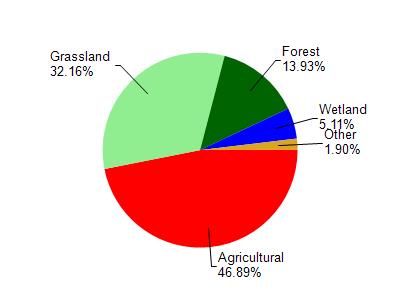
Little Sugar River is located in the Little Sugar River watershed which is 133.02 mi². Land use in the watershed is primarily agricultural (46.80%), grassland (32.10%) and a mix of forest (13.90%) and other uses (7.00%). This watershed has 351.74 stream miles, 50.40 lake acres and 3,252.10 wetland acres.
Nonpoint Source Characteristics
This watershed is ranked Not Ranked for runoff impacts on streams, Not Ranked for runoff impacts on lakes and High for runoff impacts on groundwater and therefore has an overall rank of High. This value can be used in ranking the watershed or individual waterbodies for grant funding under state and county programs.However, all waters are affected by diffuse pollutant sources regardless of initial water quality. Applications for specific runoff projects under state or county grant programs may be pursued. For more information, go to surface water program grants.