Dane
Yes
Yes
No
Fish and Aquatic Life
Overview
Schlapbach Creek rises near the northeast corner of the village of Mount Horeb and flows easterly to the Sugar River. The stream is spring fed, has very good water quality and is designated an exceptional resource water (ERW). The in-stream habitat, however, has been negatively affected by sedimentation from intense grazing of streambanks and runoff from croplands. In addition, the stormwater from Mount Horeb impacts the volume of flow in the creek. Changes in land use in the upper part of the watershed, from farming to recreation, have increased baseflow to streams in the region. More recently, several land owners in the Sletto Road area have indicated an interest in returning a portion of the riparian corridor to prairie, which should help increase rainwater infiltration and buffer the creek against nonpoint source pollution (Amrhein, pers. comm). A plan by the village of Mt. Horeb to develop a portion of the headwaters may impact runoff and infiltration. Temperature monitoring has been conducted since 2000 and a fish survey was conducted in 2002. This monitoring showed the creek has the potential to support brook trout. Fish management may stock brook trout in the stream in 2003.
Date 2006
Author Aquatic Biologist
Overview
Schlapbach Creek rises near the northeast corner of the village of Mount Horeb and flows easterly to the Sugar River. The stream is spring fed, has very good water quality and is designated an exceptional resource water (ERW). The in-stream habitat, however, has been negatively affected by sedimentation from intense grazing of streambanks and runoff from croplands. In addition, the stormwater from Mount Horeb impacts the volume of flow in the creek. Changes in land use in the upper part of the watershed, from farming to recreation, have increased baseflow to streams in the region. More recently, several land owners in the Sletto Road area have indicated an interest in returning a portion of the riparian corridor to prairie, which should help increase rainwater infiltration and buffer the creek against nonpoint source pollution (Amrhein, 2002). A plan by the village of Mt. Horeb to develop a portion of the headwaters may impact runoff and infiltration. Temperature monitoring has been conducted since 2000 and a fish survey was conducted in 2002. This monitoring showed the creek has the potential to support brook trout. Fish management stocked 10 breeding pairs of brook trout in fall, 2002. Further studies will attempt to determine the success of this stocking.
Date 2002
Author Aquatic Biologist
Historical Description
Schalpbach Creek (Klevenville Creek) -T7N, R7E, Sec. 34, Surface acres = 1.8, Length = 3.5 miles. Stream order = I. Gradient = 24.4 ft/mile, Base discharge = 2.6 cfs.
Schalpbach Creek is a small tributary which originates at Mount Horeb and flows northeast through Springdale Township (T6N, R7E) before joining the Sugar River. It drains about 5 square miles of land and its flow is augmented by several large springs in Section 8 of Springdale Township (Dane Cty. Reg. Plann. Comm. 1979a). The waters of Schalpbach Creek are moderately fertile. Erosion caused by grazing has resulted In heavy silting of the creek bottom. Access is available in Mount Horeb and at four road crossings. Fish species: central mudminnow, redilde and southern redbelly dace, bluntnose and fathead minnow, creek chub, white sucker, largemouth bass, and mottled sculpin.
From: Day, Elizabeth A.; Grzebieniak, Gayle P.; Osterby, Kurt M.; and Brynildson, Clifford L., 1985. Lake and Stream Classification Project. Surface Water Resources of Dane County, Wisconsin Department of Natural Resources, Madison, WI.
Date 1985
Author Surface Water Inventory Of Wisconsin
General Condition
Schlapbach Creek was assessed during the 2018 listing cycle; new total phosphorus, biological (fish Index of Biotic Integrity (IBI) scores), and temperature sample data were clearly below the 2018 WisCALM listing thresholds for the Fish and Aquatic Life use. This water was meeting this designated use and was not considered impaired.
Date 2017
Author Ashley Beranek
Condition
Wisconsin has over 84,000 miles of streams, 15,000 lakes and milllions of acres of wetlands. Assessing the condition of this vast amount of water is challenging. The state's water monitoring program uses a media-based, cross-program approach to analyze water condition. An updated monitoring strategy (2015-2020) is now available. Compliance with Clean Water Act fishable, swimmable standards are located in the Executive Summary of Water Condition in 2018. See also the 'monitoring and projects' tab.
Reports
Recommendations
Citizen-Based Stream Monitoring
Collect chemical, physical, and/or biological water quality data to assess the current overall stream health. The data can inform management decisions and may be used to identify impaired waters for biennial lists.
Citizen-Based Stream Monitoring
Collect chemical, physical, and/or biological water quality data to assess the current overall stream health. The data can inform management decisions and may be used to identify impaired waters for biennial lists.
Citizen-Based Stream Monitoring
Collect chemical, physical, and/or biological water quality data to assess the current overall stream health. The data can inform management decisions and may be used to identify impaired waters for biennial lists.
Rivers Management Grant
Schlapback Creek presents opportunities for a diverse and dynamic protection and management program. The goal of this grant is to implement Phase I of the emerging watershed management plan for the Schlapbch Creek watershed. Specific objectives include: Perform in-stream restoration of Schlapback Creek to favor brook trout habitat; set up a volunteer stream monitoring program; work with landowners; etc.
Rivers Management Grant
Schlapback Creek presents opportunities for a diverse and dynamic protection and management program. The goal of this grant is to implement Phase I of the emerging watershed management plan for the Schlapbch Creek watershed. Specific objectives include: Perform in-stream restoration of Schlapback Creek to favor brook trout habitat; set up a volunteer stream monitoring program; work with landowners; etc. A full description of the project goal and objectives are in the grant application- which is a part of this application.
Partnership Project
The Upper Sugar River Watershed Association will bring together a diverse set of partners to develop a small watershed management plan for Schlapbach Creek that will address the six key elements of a strategy to protect the quality of the watershed.
Management Goals
Wisconsin's Water Quality Standards provide qualitative and quantitative goals for waters that are protective of Fishable, Swimmable conditions [Learn more]. Waters that do not meet water quality standards are considered impaired and restoration actions are planned and carried out until the water is once again fishable and swimmable
Management goals can include creation or implementation of a Total Maximum Daily Load analysis, a Nine Key Element Plan, or other restoration work, education and outreach and more. If specific recommendations exist for this water, they will be displayed below online.
Monitoring
Monitoring the condition of a river, stream, or lake includes gathering physical, chemical, biological, and habitat data. Comprehensive studies often gather all these parameters in great detail, while lighter assessment events will involve sampling physical, chemical and biological data such as macroinvertebrates. Aquatic macroinvertebrates and fish communities integrate watershed or catchment condition, providing great insight into overall ecosystem health. Chemical and habitat parameters tell researchers more about human induced problems including contaminated runoff, point source dischargers, or habitat issues that foster or limit the potential of aquatic communities to thrive in a given area. Wisconsin's Water Monitoring Strategy was recenty updated.
Grants and Management Projects
Monitoring Projects
| WBIC | Official Waterbody Name | Station ID | Station Name | Earliest Fieldwork Date | Latest Fieldwork Date | View Station | View Data |
|---|
| 888500 | Schlapbach Creek | 10012235 | Schlapbach Creek at Town Hall Rd. | 10/20/2005 | 1/1/2015 | Map | Data |
| 888500 | Schlapbach Creek | 10013376 | Schalpbach Creek at Sletto Road | 11/1/2000 | 11/1/2000 | Map | Data |
| 888500 | Schlapbach Creek | 10009466 | Schlapbach Creek Upstream Sletto Rd | 5/1/1997 | 6/27/2017 | Map | Data |
| 888500 | Schlapbach Creek | 133111 | Unnamed - Wisc. Land-Cattle Ltd Mt Horeb | 3/31/1986 | 3/31/1986 | Map | Data |
| 888500 | Schlapbach Creek | 10010882 | Schlapbach Creek At Klevenville Riley Rd | 10/2/1987 | 6/27/2017 | Map | Data |
|
Watershed Characteristics
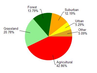
Schlapbach Creek is located in the Upper Sugar River watershed which is 105.96 mi². Land use in the watershed is primarily agricultural (42.90%), grassland (20.80%) and a mix of forest (13.80%) and other uses (22.60%). This watershed has 183.62 stream miles, 151.49 lake acres and 2,231.15 wetland acres.
Nonpoint Source Characteristics
This watershed is ranked High for runoff impacts on streams, Not Ranked for runoff impacts on lakes and High for runoff impacts on groundwater and therefore has an overall rank of High. This value can be used in ranking the watershed or individual waterbodies for grant funding under state and county programs.However, all waters are affected by diffuse pollutant sources regardless of initial water quality. Applications for specific runoff projects under state or county grant programs may be pursued. For more information, go to surface water program grants.