Dane, Iowa
Yes
No
No
Fish and Aquatic Life
Overview
Kittleson Valley is a tributary to Gordon Creek in southeast Iowa County. Seven miles are considered Class II trout waters while an additional two miles are Class III (DNR, 1980). Recreational use of this stream is impaired due to polluted runoff. Heavy sedimentation in the stream bottom (WDNR, 1992-931), is probably due to bank erosion and runoff from farm fields.
Date
Author Aquatic Biologist
Overview
Kittleson Valley Creek flows through southwestern Dane County and joins Gordon Creek in southeastern Iowa County. The middle section of this stream is a cold water stream with Class III and Class II trout sections. Severe bank erosion and overgrazing limit the fishery value of this stream (Water Resources of Dane Co, Welke, pers. obs). Fish and habitat monitoring conducted in 2002 showed the presence of cold water indicator species including brown trout, mottled sculpin and brook lamprey. Sand, silt, and clay cover the original gravel streambed. The limited iInstream cover for fish is provided by the numerous box elders which have fallen into the stream. This stream could benefit from the Conservation Reserve Enhancement Program with was recently enacted (Sorge, pers. obs).
Date 2002
Author Aquatic Biologist
Historical Description
Kittleson Valley Creek -T5N, R6E, Sec. 30, Surface acres = 2.9, Length = 8 miles. Stream order = III. Gradient = 19.3 ft/mile, Base discharge = 7.0 cfs.
This medium-sized stream is a tributary to Gordon Creek in Iowa County. Its tributaries include Jeglum Valley, Pleasant Valley, Syftestad, and York Valley Creeks. Above Hwy H, the substrate has significant areas of silt and gravel, while the percentage of gravel decreases in the lower portion of the stream (Dane Cty. Reg. Plann. Comm. 1979a). Records show 32 springs in the watershed. Temperatures are cool and flows are fairly constant in the summer but severe stream bank erosion, overgrazing, and flooding limit the fishery value of thls stream. It is presently managed as a Class II stream, but the potential exists for increasing the wild brown trout fishery. A diverse grouping of forage species are present. Small pockets of wet meadow are found along the creek's lower stretches. Six road crossings provide access.
Fish species: brown trout, brassy minnow, hornyhead chub, common shiner, southern redbelly dace, bluntnose minnow, creek chub, white sucker, green sunfish, fantail and Johnny darter, and mottled sculpln.
From: Day Elizabeth A.; Grzebieniak, Gayle P.; Osterby, Kurt M.; and Brynildson, Clifford L., 1985. Lake and Stream Classification Project. Surface Water Inventory of Dane County. Wisconsin Department of Natural Resources, Madison, WI
Date 1985
Author Surface Water Inventory Of Wisconsin
Historical Description
Kittleson Valley Creek -Mouth location T5N R5E Section 35 -16, Surface area = 2.3 acres, Length = 0.9 miles, Gradient = 42.3 feet per mile, Total alkalinity = 260.0 rng/l, Volume of flow = 12.0 cfs.
This stream originates in Dane County, wherein most of its watershed lies, and flows southwesterly into Iowa County where it becomes the principal tributary of Blue Mounds Branch (Gordon Creek), contributing about 33 percent of its base flow.
Most of its watershed is cleared for farming which results in the severe flooding of the basin and heavy bank erosion in some sections. There is a possible source of pollution from a dairy located near the county line. This is monitored by the Division of Environmental Protection.
The sport fishery consists of brown trout in the upper section in Dane County, where they are stocked annually. The lower sections, in Iowa County, contain smallmouth bass. Forage fishes present include white suckers, hogsuckers, stoneroller minnows, rosyface shiners, and johnny darters.
Aquatic game assets include muskrats which are common throughout its length and some waterfowl in the wider sections. There are no public lands in Iowa County but it is accessible from a town road crossing.
From: Piening, Ronald and Threinen, C.W., 1968. Lake and Stream Classification Project. Surface Water Resources of Iowa County, Wisconsin Department of Natural Resources, Madison, WI.
Date 1968
Author Surface Water Inventory Of Wisconsin
General Condition
Kittleson Valley Creek (miles 2.79-6.7) was assessed during the 2018 listing cycle; new biological (fish Index of Biotic Integrity (IBI) scores) sample data were clearly below the 2018 WisCALM listing thresholds for the Fish and Aquatic Life use. This water was meeting this designated use and was not considered impaired.
Date 2017
Author Ashley Beranek
General Condition
Kittleson Valley Creek (CTH H to the headwaters) was assessed during the 2018 listing cycle; new biological (fish Index of Biotic Integrity (IBI) scores) and temperature sample data were clearly below the 2018 WisCALM listing thresholds for the Fish and Aquatic Life use. This water was meeting this designated use and was not considered impaired.
Date 2017
Author Ashley Beranek
Condition
Wisconsin has over 84,000 miles of streams, 15,000 lakes and milllions of acres of wetlands. Assessing the condition of this vast amount of water is challenging. The state's water monitoring program uses a media-based, cross-program approach to analyze water condition. An updated monitoring strategy (2015-2020) is now available. Compliance with Clean Water Act fishable, swimmable standards are located in the Executive Summary of Water Condition in 2018. See also the 'monitoring and projects' tab.
Reports
Recommendations
Educate and engage residents
The Green-Rock Audubon Society will initiate a public awareness campaign and fund raising events to begin the process of acquiring land that will protect the two large flowing springs that form a headwater tributary to Kittleson Creek.
Management Goals
Wisconsin's Water Quality Standards provide qualitative and quantitative goals for waters that are protective of Fishable, Swimmable conditions [Learn more]. Waters that do not meet water quality standards are considered impaired and restoration actions are planned and carried out until the water is once again fishable and swimmable
Management goals can include creation or implementation of a Total Maximum Daily Load analysis, a Nine Key Element Plan, or other restoration work, education and outreach and more. If specific recommendations exist for this water, they will be displayed below online.
Monitoring
Monitoring the condition of a river, stream, or lake includes gathering physical, chemical, biological, and habitat data. Comprehensive studies often gather all these parameters in great detail, while lighter assessment events will involve sampling physical, chemical and biological data such as macroinvertebrates. Aquatic macroinvertebrates and fish communities integrate watershed or catchment condition, providing great insight into overall ecosystem health. Chemical and habitat parameters tell researchers more about human induced problems including contaminated runoff, point source dischargers, or habitat issues that foster or limit the potential of aquatic communities to thrive in a given area. Wisconsin's Water Monitoring Strategy was recenty updated.
Grants and Management Projects
Monitoring Projects
| WBIC | Official Waterbody Name | Station ID | Station Name | Earliest Fieldwork Date | Latest Fieldwork Date | View Station | View Data |
|---|
| 907900 | Kittleson Valley Creek | 10030235 | Kittleson Valley Creek-280m DS of Drumon Valley bridge | | | Map | Data |
| 907900 | Kittleson Valley Creek | 133444 | Kittleson Valley Creek - (Bridge) | 6/2/2003 | 11/26/2019 | Map | Data |
| 907900 | Kittleson Valley Creek | 10015428 | Kittleson Valley Creek - Upstream Sth 78 | 4/21/2008 | 6/27/2019 | Map | Data |
| 907900 | Kittleson Valley Creek | 10010041 | Kittleson Valley Creek Remap 179-X | | | Map | Data |
| 907900 | Kittleson Valley Creek | 133443 | Kittleson Valley Creek - Kittleson Valley Creek | 6/2/2003 | 11/7/2003 | Map | Data |
| 907900 | Kittleson Valley Creek | 10011720 | Kittleson Valley Creek - Drumon Valley Rd. Bridge Upsteam | 4/21/2008 | 1/1/2015 | Map | Data |
| 907900 | Kittleson Valley Creek | 10009432 | Kittleson Valley Upstream Hwy H Bridge | 6/5/2008 | 12/4/2019 | Map | Data |
| 907900 | Kittleson Valley Creek | 10010042 | Kittleson Valley Creek - Kittleson Valley Creek Remap 179-B | 11/11/2002 | 11/11/2002 | Map | Data |
|
Watershed Characteristics
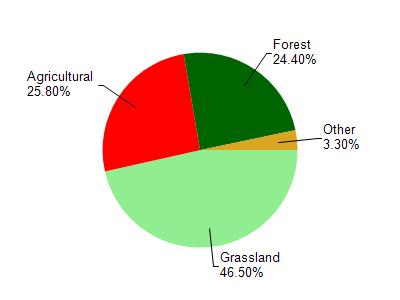
Kittleson Valley Creek is located in the Gordon Creek watershed which is 76.90 mi². Land use in the watershed is primarily grassland (46.50%), agricultural (25.80%) and a mix of forest (24.40%) and other uses (3.30%). This watershed has 205.79 stream miles, 7.11 lake acres and 487.25 wetland acres.
Nonpoint Source Characteristics
This watershed is ranked High for runoff impacts on streams, Not Ranked for runoff impacts on lakes and High for runoff impacts on groundwater and therefore has an overall rank of High. This value can be used in ranking the watershed or individual waterbodies for grant funding under state and county programs.However, all waters are affected by diffuse pollutant sources regardless of initial water quality. Applications for specific runoff projects under state or county grant programs may be pursued. For more information, go to surface water program grants.