Lafayette
No
No
No
Fish and Aquatic Life
Overview
The Bonner Branch is a low gradient stream that is a tributary to the West Branch of the Pecatonica River. The Lactaus Cheese Factory and the Belmont wastewater treatment plant discharge to the stream. Interestingly, a 1967 surface water resources inventory reports that Bonner Branch “provides one(sic) of the best fishing in this part of the county” (DNR, 1967). Since then, however, numerous fish kills have plagued the stream over the years. The cause for the kills has varied from point source discharges, manure spills (1993 and 1999), and leaking slurry tanks (1994). Subsequent surveys conducted after these kills showed the presence of fewer fish species. The fishery manager feels the water quality of the stream has degraded from one that supports warm water sport fish to one that can only support forage fish (Bradd,pers comm).
Date 2002
Author Aquatic Biologist
Historical Description
Bonner Branch, T3N, R3E, Sections 8-11, Surface acres- = 21.5, Miles = 13.5, Gradient = 18.2 feet per mile, Total alkalinity = 288 mg/l, Volume of flow = 8.9 cfs.
Bonner Branch has a lower than average stream gradient for a Lafayette County stream and flows northeasterly into the West Branch of the Pecatonica River. Its major tributary is Cottage Inn Branch which is a good smallmouth bass and channel catfish stream. In conjunction with this tributary, Bonner Branch provides one of the best sport fishing in this part of the county. Most of the land area in the watershed is considered agricultural; however, there is a considerable amount of woods and meadow pasture along its banks to provide suitable nesting habitat for waterfowl and some upland game. Urban development is limited to the town of Belmont located on the upper portion of the stream. Industrial pollution from
this municipality has been a problem in the past.The Belmont sewage treatment plant is located on the stream southeast
of town. There is no other land on the stream in public ownership. Suitable access is possible from the many road bridges located along its length.
From: Piening, Ronald; Poff, Ronald; Threinen, C.W., 1967. Lake and Stream Classification Project. Surface Water Resources of Lafayette County, Wisconsin Department of Natural Resources, Madison, WI.
Date 1967
Author Surface Water Inventory Of Wisconsin
General Condition
Bonner Branch was assessed during the 2018 listing cycle; new biological (macroinvertebrate Index of Biotic Integrity (IBI) scores) sample data were clearly below the 2018 WisCALM listing thresholds for the Fish and Aquatic Life use. This water was meeting this designated use and was not considered impaired.
Date 2017
Author Ashley Beranek
Condition
Wisconsin has over 84,000 miles of streams, 15,000 lakes and milllions of acres of wetlands. Assessing the condition of this vast amount of water is challenging. The state's water monitoring program uses a media-based, cross-program approach to analyze water condition. An updated monitoring strategy (2015-2020) is now available. Compliance with Clean Water Act fishable, swimmable standards are located in the Executive Summary of Water Condition in 2018. See also the 'monitoring and projects' tab.
Reports
Management Goals
Wisconsin's Water Quality Standards provide qualitative and quantitative goals for waters that are protective of Fishable, Swimmable conditions [Learn more]. Waters that do not meet water quality standards are considered impaired and restoration actions are planned and carried out until the water is once again fishable and swimmable
Management goals can include creation or implementation of a Total Maximum Daily Load analysis, a Nine Key Element Plan, or other restoration work, education and outreach and more. If specific recommendations exist for this water, they will be displayed below online.
Monitoring
Monitoring the condition of a river, stream, or lake includes gathering physical, chemical, biological, and habitat data. Comprehensive studies often gather all these parameters in great detail, while lighter assessment events will involve sampling physical, chemical and biological data such as macroinvertebrates. Aquatic macroinvertebrates and fish communities integrate watershed or catchment condition, providing great insight into overall ecosystem health. Chemical and habitat parameters tell researchers more about human induced problems including contaminated runoff, point source dischargers, or habitat issues that foster or limit the potential of aquatic communities to thrive in a given area. Wisconsin's Water Monitoring Strategy was recenty updated.
Grants and Management Projects
| Project Name (Click for Details) | Year Started |
|---|
|
|
Monitoring Projects
| WBIC | Official Waterbody Name | Station ID | Station Name | Earliest Fieldwork Date | Latest Fieldwork Date | View Station | View Data |
|---|
| 927000 | Bonner Br | 10012127 | Bonner Br - Upstream Of Spring St. Ln. | | | Map | Data |
| 927000 | Bonner Br | 333251 | Bonner Branch at CTH G | 10/6/2004 | 10/6/2004 | Map | Data |
| 927000 | Bonner Br | 10012120 | Bonner Br Fish Kill Station (Aka) - Upstream Of Cty. Rd. G | | | Map | Data |
| 927000 | Bonner Br | 10044440 | Bonner Branch - 1st Capitol Ave in Belmont | 1/1/2015 | 10/19/2015 | Map | Data |
| 927000 | Bonner Br | 333036 | Bonner Branch - A Cth G Bl Belmont | 5/12/1975 | 12/4/1975 | Map | Data |
| 927000 | Bonner Br | 333035 | Bonner Branch - Below Belmont Stp | 5/12/1975 | 8/10/2009 | Map | Data |
| 927000 | Bonner Br | 10037901 | Bonner Branch at Landon Road | 7/26/2012 | 10/19/2015 | Map | Data |
| 927000 | Bonner Br | 10032523 | Bonner Branch at Hwy. G Belmont | | | Map | Data |
| 927000 | Bonner Br | 10058832 | Bonner Branch at CTH C | 5/16/2024 | 10/17/2024 | Map | Data |
| 927000 | Bonner Br | 10030606 | Bonner Creek above confluence with Unnamed Cr (S of HWY G) | 1/1/2015 | 1/1/2015 | Map | Data |
| 927000 | Bonner Br | 10012126 | Bonner Br - Upstream Of Cty. Rd. O | 1/1/2015 | 10/19/2015 | Map | Data |
| 927000 | Bonner Br | 10044439 | Bonner Branch - 1st ATV bridge upstrm of junction CTH C and G | 1/1/2015 | 10/19/2015 | Map | Data |
|
Watershed Characteristics
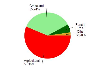
Bonner Br is located in the Middle Pecatonica River watershed which is 186.42 mi². Land use in the watershed is primarily agricultural (56.30%), grassland (35.70%) and a mix of forest (5.70%) and other uses (2.20%). This watershed has 484.82 stream miles, 27.78 lake acres and 298.28 wetland acres.
Nonpoint Source Characteristics
This watershed is ranked Not Ranked for runoff impacts on streams, Not Ranked for runoff impacts on lakes and High for runoff impacts on groundwater and therefore has an overall rank of High. This value can be used in ranking the watershed or individual waterbodies for grant funding under state and county programs.This water is ranked High Stream for individual Rivers based on runoff problems and the likelihood of success from project implementation.