Grant, Iowa
Yes
No
No
Fish and Aquatic Life
Overview
The Platte River rises near the community of Montfort on the south flank of the Military Ridge. It flows 47 miles to its confluence with the Mississippi River at Pool 11 near Dickeyville. The river winds through scenic areas and offers recreational potential for canoeing in some reaches. About 5.5 miles of it above the Annaton Road crossing near Annaton are considered class II trout waters. Here the stream has a moderate to fast current, and narrow to medium width with numerous riffles and smaller pools. Downstream the water warms as it becomes wider and the stream classification changes to a warm water sport fishery stream. The reach downstream of Annaton supports a smallmouth bass fishery. Recent reconnaissance of the smallmouth bass fishery in the river turned up few bass and fish monitoring done at two sites on the Platte River between 1994 and 1996 has shown a fluctuating bass population (Kerr, 1998; Wang, et.al.,1996). Closer to its mouth the sport fishery becomes more dominated by channel catfish and northern pike.
The Platte River carries a very large load of sediment to the Mississippi River annually. The cumulative impact of the excessive nutrient loading from the entire Mississippi River basin, particularly the upper portion in Iowa, Illinois, Minnesota and Wisconsin, can be seen in the hypoxia problem in the Gulf of Mexico (EPA, 1999). The sediment from the Platte River Watershed also fills pools in the Platte River affecting instream habitat. Nonpoint sources of pollution appear to be the primary impairment of habitat and water quality in the stream. Nutrients attached to the sediment encourage excessive aquatic plant and/or algae growth. Recent macroinvertebrate monitoring indicated that the stream has better water quality than most of the streams monitored (Marshall, 1999). Overall, these results have shown the river to have good water quality with a higher percentage of mayflies, caddisflies and stoneflies than the other streams monitored at the same time. Despite this, however, there was also a large population of midges, which can indicate ecological disturbances that often can be attributed to agricultural sources of nonpoint pollution. A western tributary to the Platte River that enters just above Bacon Branch was also sampled. Those samples found good water quality, but with a higher percentage of midges and fewer mayflies, caddisflies, and stoneflies (Marshall, 1999). A high percentage of midges can be an indication that the stream is impacted from agricultural sources of nonpoint pollution (Gamman, 1983).
A group of citizen volunteer stream monitors have taken an interest in the water quality of the river. The group began monitoring water clarity, temperature, and dissolved oxygen downstream from Rock Church Road in the summer of 2000. The group found this section of the river to have good water temperature and dissolved oxygen levels while water clarity could be low after a rain event (Trout Unlimited, 2001).
Two pollution intolerant species listed on Wisconsin’s threatened and endangered species list have historically been found in the Platte River (WDNR, 1997). Nonpoint source best management practices, particularly in the reach above Annaton Road, would help protect and improve the stream and protect aquatic habitat and wildlife. Specific best management practices would include adequate stream buffers and managed grazing.
Date 2001
Author Aquatic Biologist
Historical Description
From: Smith, Tom D., and Ball, Joseph R., Lake and Stream Classification Project. Surface Water Resources of Grant County, Department of Natural Resources, 1972. Surface Area = 331.70 acres, Length = 45.6 miles, Gradient = 11 ft./mile, Flow = 207.3 c.f.s.
A low-gradient, seepage- and spring-fed stream originating in the dominating agricultural landscape south of Montfort. From here it flows southwest to enter the Mississippi River three miles southwest of Dickeyville. It is characterized by having a wide floodplain and many spring-fed tributaries producing the dendritic drainage pattern common to this part of the country. Small boulders are strewn over much of the predominantly gravel-rubble stream bed. The uppermost five miles of this stream is locally known as "Seven Foot Branch". This portion of the stream is managed as trout water, and brown and rainbow trout are stocked annually by the Department of Natural Resources. It has never harbored a high density of trout and the lower reaches contain
a better smallmouth bass population than trout. Smallmouth bass provide a good fishery throughout the rest of the stream while northern pike and channel catfish supply a limited fishery as far upstream as Ellenboro. Forage species are abundant throughout, and rough fish are seined commercially in the lower reaches below the mouth of the Little Platte River. Remnants of the Old Annaton Mill Dam can still be seen in the upper reaches. Inadequate finances discouraged the building of another dam in this same general area a few years ago. Over- grazing and bank erosion are problems seen in several areas along this stream. Small amounts of pollution enter from feedlots on the stream and from several spring-fed tributaries. Adjoining wetland totals 998 acres of which 60 percent is shallow marsh, 30 percent is fresh meadow, seven percent is shrub swamp, and three percent is timber swamp. Marshland furbearers include muskrat, beaver, and mink. Migratory waterfowl are common in the lower reaches. Many of the upland game species are also found in this large watershed. Navigable water access is possible from the Mississippi River. Additional access is provided by the boat landing in the Banfield Bridge Recreation Area, a boat landing along Highway 35, and 19 bridge crossings.
Date 1972
Author Surface Water Inventory Of Wisconsin
General Condition
Platte River (WBIC 943600) from Annaton Rd. to the headwaters was assessed during the 2018 listing cycle; new biological (fish Index of Biotic Integrity (IBI) scores) sample data were clearly below the 2018 WisCALM listing thresholds for the Fish and Aquatic Life use. This portion of the water was meeting this designated use and was not considered impaired.
Date 2017
Author Ashley Beranek
Impaired Waters
Platte River (943600), from the mouth to Annaton Rd., was placed on the impaired waters list for total phosphorus in 2012. The 2016 assessments showed continued impairment by phosphorus; total phosphorus sample data exceeded 2016 WisCALM listing criteria for the Fish and Aquatic Life use, however, available biological data did not indicate impairment (i.e. no macroinvertebrate or fish Index of Biotic Integrity (IBI) scored in the "poor" condition category). Based on the most updated information, no change in existing impaired waters listing is needed.
Date 2015
Author Aaron Larson
Condition
Wisconsin has over 84,000 miles of streams, 15,000 lakes and milllions of acres of wetlands. Assessing the condition of this vast amount of water is challenging. The state's water monitoring program uses a media-based, cross-program approach to analyze water condition. An updated monitoring strategy (2015-2020) is now available. Compliance with Clean Water Act fishable, swimmable standards are located in the Executive Summary of Water Condition in 2018. See also the 'monitoring and projects' tab.
Reports
Recommendations
Rivers Planning Grant
The Friends of the Platte River, Inc. will develop a plan for establishing and maintaining a Water Trail on the Platte River. The project will locate points for access and will develop plans for launch site improvements. Project deliverables include: 1) a comprehensive plan for a water trail on the Platte River from Ellenboro to the Mississippi with specific sites noted, conduction drawings, permitting requirements, budget and timeline, 2) completed modeling of sediments deposition rates in the Platte River with recommendations for restoration and future action and results from preliminary pilot field studies, 3) increased membership in the Friends of the Platte River organization by inclusion of local sportsmen/stakeholders at least 50 percent and attendance to educational events by 50 percent, 4) specific plan for obtaining funding/partnership for water trail projects, 5) produce a minimum of four interviews, articles, and letters to the editor for publications in local print media and on the website, 5) quarterly planning meetings/events with local stakeholders.
Educate and engage residents
The main goal of this project is to solidify and expand the Friends of the Platte River group. Objectives include: 1) membership expansion; 2) increasing public awareness and providing education through various media; and 3) participation in a formal organization assessment.
Rivers Management Grant
The grant will support the formation of a river management organization for the Platte River watershed. Funds will be used to hire a part time coordinator preparing and mailing printed materials, facility rental and other support functions. The focus of the organization will be advocating for improved water quality and improving receational use of the river.
Management Goals
Wisconsin's Water Quality Standards provide qualitative and quantitative goals for waters that are protective of Fishable, Swimmable conditions [Learn more]. Waters that do not meet water quality standards are considered impaired and restoration actions are planned and carried out until the water is once again fishable and swimmable
Management goals can include creation or implementation of a Total Maximum Daily Load analysis, a Nine Key Element Plan, or other restoration work, education and outreach and more. If specific recommendations exist for this water, they will be displayed below online.
Monitoring
Monitoring the condition of a river, stream, or lake includes gathering physical, chemical, biological, and habitat data. Comprehensive studies often gather all these parameters in great detail, while lighter assessment events will involve sampling physical, chemical and biological data such as macroinvertebrates. Aquatic macroinvertebrates and fish communities integrate watershed or catchment condition, providing great insight into overall ecosystem health. Chemical and habitat parameters tell researchers more about human induced problems including contaminated runoff, point source dischargers, or habitat issues that foster or limit the potential of aquatic communities to thrive in a given area. Wisconsin's Water Monitoring Strategy was recenty updated.
Grants and Management Projects
Monitoring Projects
| WBIC | Official Waterbody Name | Station ID | Station Name | Earliest Fieldwork Date | Latest Fieldwork Date | View Station | View Data |
|---|
| 943600 | Platte River | 10044211 | Platte River at LaPlatte Rd | 1/1/2015 | 1/1/2015 | Map | Data |
| 943600 | Platte River | 223320 | Platte River - Annaton Rd | 6/1/1992 | 1/1/2015 | Map | Data |
| 943600 | Platte River | 10031493 | Platte River at confluence of T5N R1W 8-11 STR | 1/1/2015 | 1/1/2015 | Map | Data |
| 943600 | Platte River | 10013218 | Platte River (Rock Church Road) | 1/1/2015 | 1/1/2015 | Map | Data |
| 943600 | Platte River | 10011514 | Plattte River - Above Annaton Rd | 1/1/2015 | 1/1/2015 | Map | Data |
| 943600 | Platte River | 223117 | Platte River - Hopewell Rd. | 4/15/1980 | 1/1/2015 | Map | Data |
|
Watershed Characteristics
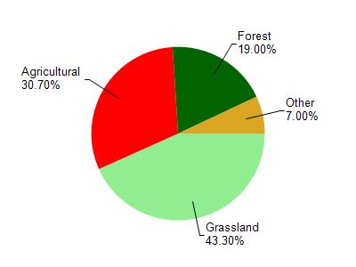
Platte River is located in the Platte River watershed which is 197.74 mi². Land use in the watershed is primarily grassland (43.30%), agricultural (30.70%) and a mix of forest (19%) and other uses (7.00%). This watershed has 455.07 stream miles, 21.45 lake acres and 1,303.48 wetland acres.
Nonpoint Source Characteristics
This watershed is ranked Medium for runoff impacts on streams, Not Available for runoff impacts on lakes and High for runoff impacts on groundwater and therefore has an overall rank of High. This value can be used in ranking the watershed or individual waterbodies for grant funding under state and county programs.This water is ranked High Stream for individual Rivers based on runoff problems and the likelihood of success from project implementation.