Grant
Yes
Yes
No
Fish and Aquatic Life
Overview
The Little Platte River rises in Livingston and flows southerly to its confluence with the Platte River near Dickeyville. Many reaches of the stream flow through scenic rural landscapes including some areas with steep limestone bluffs that rise above the river. White pine dominates some of the steep bluffs creating micro-ecosystems generally uncommon in this area.
The headwaters of the Little Platte River are in the Village of Livingston. From the headwaters downstream 1.5 miles the stream is classified as a Limited Forage Fishery (LFF) stream. The stream is considered to be a class II trout stream (WDNR, 1980) from the LFF reach downstream four miles. The remainder of the Little Platte is classified as a warm water sport fishery (WWSF) and a regionally important smallmouth bass fishery stream, second only to the Galena River in southwest Wisconsin. The significance of the smallmouth bass fishery is one reason the stream was put on Wisconsin’s Exceptional Resource Waters (ERW) list. The smallmouth bass fishery of the Little Platte has seen fluctuations in populations over the years (Mason et.al., 1993). Monitoring conducted in 1993 found few bass in the Little Platte River, however, 1996 monitoring indicated that the Little Platte had one of the best smallmouth bass populations in southwestern Wisconsin, a significant rebound in population from the 1993 survey (Wang et.al., 1996).
It appears that a number of factors may affect the bass populations. Major runoff events, particularly during the critical late spring period, appear to have an adverse impact on populations. These runoff events are usually associated with dissolved oxygen levels that often fall below water quality standards. Non-point sources of pollution such as excessive streambank pasturing, streambank erosion, and runoff from barnyards and cultivated fields, can and do have an effect on instream habitat and water quality and aquatic life. Populations are higher in years of few, or smaller, major runoff events and when baseflow (average stream flow during dry periods) is higher.
Date 2001
Author Aquatic Biologist
Historical Description
Due in part to the stream’s value as a smallmouth fishery and to the threats the stream faces from non-point source pollution, volunteer citizen stream monitors have taken an interest in the stream and have been collecting data at two locations on the Little Platte River, one site is above the Highway 80 bridge in Arthur, the other is 300 feet upstream from Maple Ridge Road (Trout Unlimited 2001).
Samples taken at both sites last spring and summer found good temperatures and dissolved oxygen. Spring and summer NTU values (Nephelometeric Turbidity Units), or the measure of water clarity or turbidity, were fair to good. Overall, most samples were below the stress level, although on certain days, NTU’s were high. Low water clarity, or high turbidity is often an indication of a problem with non-point source pollution. The higher the volume of solids in the water column, the lower the water clarity. After a rainfall event, turbidity readings are generally higher (Trout Unlimited, 2001).
The monitors began to take samples again this past March, 2001 at the Arthur site. Dissolved oxygen levels were lower, but still sufficient, as a result of cooler temperatures, and with the exception of March 19, all turbidity values were below the stress level (Trout Unlimited, 200).
In addition to its value as a smallmouth bass stream, the Little Platte River has been known to be home for some rare aquatic species. Two pollution intolerant species listed on the Wisconsin threatened and endangered species list have been found in the Little Platte River.
The only permitted wastewater discharge to the Little Platte River is from the Village of Livingston. Livingston has had a problem with the operation of its wastewater treatment system. High flows and equipment malfunctions have led to bypassing of untreated sewage to the Little Platte. The Village has taken steps to address and correct these problems.
Date 2001
Author Aquatic Biologist
Historical Description
A seepage- and spring-fed stream beginning just south of Livingston and flowing southwest to empty into, the Platte River two miles northwest of Dickeyville. The upper six miles of the stream, sometimes called "Arthur Branch", is considered a cold-water stream and the remainder is a sluggish warmwater stream. About four miles of "Arthur Branch" is managed as marginal trout water. Brown and rainbow yearlings have been stocked by the Department of Natural Resources. Trout are also stocked from the Iowa-Grant Rearing Pond located along this section of stream. The portion of the stream below trout water is wide and sluggish with many deep pools and long boulder-rubble riffles. This portion is considered to be some of the best small- mouth bass water in Grant County. Catfish are found as far upstream as the mouth of the Rountree Branch. Forage fish are abundant throughout. A dam was to be constructed on the stream below the mouth of the Rountree Branch in the past, but it was never developed. Only about 30 percent of the watershed is covered by woodlands inhabited by raccoon, squirr deer, and ruffed grouse. Muskrat, mink, and beaver frequent the 781 acres of productive wetland adjoining th lower reaches of the stream. Overgrazing and bank erosion are major use problems throughout the watershed. A severe fish kill occurred on the trout stream portion in June, 1969, as a result of pollution from milk processing. This creamery has stopped operation since that time. A large amount of polluted water was entering from the Rountree Branch when this survey was conducted. The Village of Livingston and the Livingston Creamery Company are also considered to be potential sources of pollution. The stream is easily' accessible from 2.1S miles of stream easement and lS bridge crossings. The Platte River provides navigable water access.
From: Smith, Tom D., and Ball, Joseph R., Lake and Stream Classification Project. Surface Water Resources of Grant County, Department of Natural Resources, 1972. Surface Area = 142.20 acres, Length = 39.1 miles, Gradient = .12 ft./mile, Flow = 103.3 c.f.s.
Date 1972
Author Aquatic Biologist
Recommendations
Partnership Project
The Platteville Area Stream Stewardship Network will build an organization that empowers individuals to implement changes that improve water quality.
Runoff Grant
The Little Platte River watershed should be considered by the DNR, Wisconsin Department of Agriculture, Trade and Consumer Protection, and Grant County as a high priority candidate a non-point source pollution abatement project. Specifically, Targeted Runoff Management (TRM) or EQIP projects should be considered by the DNR and Grant County for all or portions of the Little Platte River, Blockhouse Creek, Mounds Branch, Rountree Branch, and/or Snowden Branch
Result: Snowden Branch (done- see attached report)
Stormwater Planning, Implementation
The City of Platteville, with the assistance of the DNR, Southwestern Wisconsin Regional Planning Agency, and Southwest Badger RC&D, should address stormwater management issues and problems in the city.
Result: Stormwater plan written in 2006. Utility rejected by City council. They will be over 10,000 in the next census and will be required to have a permit.
Management Goals
Wisconsin's Water Quality Standards provide qualitative and quantitative goals for waters that are protective of Fishable, Swimmable conditions [Learn more]. Waters that do not meet water quality standards are considered impaired and restoration actions are planned and carried out until the water is once again fishable and swimmable
Management goals can include creation or implementation of a Total Maximum Daily Load analysis, a Nine Key Element Plan, or other restoration work, education and outreach and more. If specific recommendations exist for this water, they will be displayed below online.
Monitoring
Monitoring the condition of a river, stream, or lake includes gathering physical, chemical, biological, and habitat data. Comprehensive studies often gather all these parameters in great detail, while lighter assessment events will involve sampling physical, chemical and biological data such as macroinvertebrates. Aquatic macroinvertebrates and fish communities integrate watershed or catchment condition, providing great insight into overall ecosystem health. Chemical and habitat parameters tell researchers more about human induced problems including contaminated runoff, point source dischargers, or habitat issues that foster or limit the potential of aquatic communities to thrive in a given area. Wisconsin's Water Monitoring Strategy was recenty updated.
Grants and Management Projects
Monitoring Projects
| WBIC | Official Waterbody Name | Station ID | Station Name | Earliest Fieldwork Date | Latest Fieldwork Date | View Station | View Data |
|---|
| 943800 | Little Platte River | 223247 | Little Platte River - Sth 80 S11 | 5/10/1979 | 1/1/2015 | Map | Data |
| 943800 | Little Platte River | 10030379 | Little Platte River at Waterfall Road | 10/26/2009 | 1/1/2015 | Map | Data |
| 943800 | Little Platte River | 10031707 | Little Platte River upstream of Cushman Rd Bridge | 1/1/2015 | 1/1/2015 | Map | Data |
| 943800 | Little Platte River | 223335 | Little Platte River at Cth A | | | Map | Data |
| 943800 | Little Platte River | 10039555 | Little Platte River SE of STH 80 and Cushman Rd | 6/10/2000 | 4/9/2025 | Map | Data |
| 943800 | Little Platte River | 10040400 | Little Platte River 0.5 mi DS STH 80 | 10/22/2012 | 9/19/2019 | Map | Data |
|
Watershed Characteristics
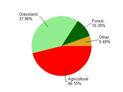
Little Platte River is located in the Little Platte River watershed which is 154.94 mi². Land use in the watershed is primarily agricultural (46.20%), grassland (38%) and a mix of forest (10.40%) and other uses (5.50%). This watershed has 389.19 stream miles, 19.99 lake acres and 585.06 wetland acres.
Nonpoint Source Characteristics
This watershed is ranked High for runoff impacts on streams, Not Available for runoff impacts on lakes and High for runoff impacts on groundwater and therefore has an overall rank of High. This value can be used in ranking the watershed or individual waterbodies for grant funding under state and county programs.However, all waters are affected by diffuse pollutant sources regardless of initial water quality. Applications for specific runoff projects under state or county grant programs may be pursued. For more information, go to surface water program grants.