Grant
Yes
No
Yes
Fish and Aquatic Life
Overview
Martin Branch is a spring-fed tributary to the Little Grant River. About two miles of the stream are considered as class II trout waters (WDNR, 1980). The remaining reaches are considered as forage fishery and warm water sport fishery reaches (Fix, 1991). Non-point sources of pollution affect instream water quality and habitat and the stream is listed on the state’s list of impaired waters (303d). The sources of these problems are excessive streambank grazing, barnyard runoff and sediment from farm field erosion (Fix, 1991). No recent assessment of water quality or instream habitat has been done to determine current conditions. The DNR, in cooperation with some local landowners, has done some streambank and instream habitat improvements. The DNR has also acquired some public easements from local landowners.
Date 2001
Author Aquatic Biologist
Historical Description
From: Smith, Tom D., and Ball, Joseph R., Lake and Stream Classification Project. Surface Water Resources of Grant County, Department of Natural Resources, 1972. Surface Area = 4.95 acres, Length = 3.4 miles, Gradient = 23 ft./mile, Flow = 7.0 c.f.s.
A spring-fed stream entering the Little Grant River from the north four miles northwest of Lancaster. About two miles of this stream are managed as trout water. Both brown and brook trout yearlings are stocked. Some natural reproduction of brown trout has been found while the large pools harbor trophy trout for the fisherman. Typical of the streams in this area. smallmouth bass are common in the lower reaches. An abundant forage fish population also inhabits the stream. Aquatic bug life production is common to abundant throughout the stream. Bank cover is lacking except for an occasional basswood tree. Water and soil control structures are needed in the headwaters to lessen the rapid runoff and subsequent bank erosion. The construction of cattle crossings and bank repair would also greatly preserve stream habitat. Game assets include muskrats, mink, raccoon, deer, and squirrels. Public access is possible from two bridge crossings. Five farm dwellings adjoin the stream.
Date 1972
Author Surface Water Inventory Of Wisconsin
Condition
Wisconsin has over 84,000 miles of streams, 15,000 lakes and milllions of acres of wetlands. Assessing the condition of this vast amount of water is challenging. The state's water monitoring program uses a media-based, cross-program approach to analyze water condition. An updated monitoring strategy (2015-2020) is now available. Compliance with Clean Water Act fishable, swimmable standards are located in the Executive Summary of Water Condition in 2018. See also the 'monitoring and projects' tab.
Reports
Recommendations
TMDL (USEPA) Approved
EPA finds that the TMDLs for Martin Branch, Martinville Creek, and Rogers Branch satisfies all of the elements of approvable TMDLs. This approval addresses 15 TMDLs for 10 waterbody segments and 15 impairments from the 2006 Wisconsin 303(d) list.
Management Goals
Wisconsin's Water Quality Standards provide qualitative and quantitative goals for waters that are protective of Fishable, Swimmable conditions [Learn more]. Waters that do not meet water quality standards are considered impaired and restoration actions are planned and carried out until the water is once again fishable and swimmable
Management goals can include creation or implementation of a Total Maximum Daily Load analysis, a Nine Key Element Plan, or other restoration work, education and outreach and more. If specific recommendations exist for this water, they will be displayed below online.
Monitoring
Monitoring the condition of a river, stream, or lake includes gathering physical, chemical, biological, and habitat data. Comprehensive studies often gather all these parameters in great detail, while lighter assessment events will involve sampling physical, chemical and biological data such as macroinvertebrates. Aquatic macroinvertebrates and fish communities integrate watershed or catchment condition, providing great insight into overall ecosystem health. Chemical and habitat parameters tell researchers more about human induced problems including contaminated runoff, point source dischargers, or habitat issues that foster or limit the potential of aquatic communities to thrive in a given area. Wisconsin's Water Monitoring Strategy was recenty updated.
Grants and Management Projects
Monitoring Projects
| WBIC | Official Waterbody Name | Station ID | Station Name | Earliest Fieldwork Date | Latest Fieldwork Date | View Station | View Data |
|---|
|
|
Watershed Characteristics
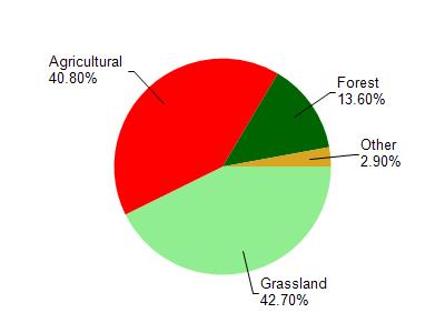
Martin Br is located in the Upper Grant River watershed which is 106.09 mi². Land use in the watershed is primarily grassland (42.70%), agricultural (40.80%) and a mix of forest (13.60%) and other uses (2.90%). This watershed has 260.94 stream miles, 7.24 lake acres and 6.79 wetland acres.
Nonpoint Source Characteristics
This watershed is ranked High for runoff impacts on streams, Not Available for runoff impacts on lakes and High for runoff impacts on groundwater and therefore has an overall rank of High. This value can be used in ranking the watershed or individual waterbodies for grant funding under state and county programs.However, all waters are affected by diffuse pollutant sources regardless of initial water quality. Applications for specific runoff projects under state or county grant programs may be pursued. For more information, go to surface water program grants.