Vernon
Yes
No
No
Fish and Aquatic Life
Overview
Seas Branch, located in central Vernon County, flows in an easterly direction for 4.5 miles
before reaching the West Fork of the Kickapoo River near Avalanche. This stream has a
gradient of 50 feet per mile and drains forested hillsides, an agricultural valley and an
agricultural headwater plateau. A wet flood control structure which creates the 11-acre Seas
Branch Pond is located approximately 2.5 miles upstream from the mouth of the stream.
In 1997, Seas Branch contained a self-sustaining brown trout population throughout its entire
length. Water temperatures and habitat in Seas Branch upstream of the flood control structure
was conducive to the establishment of a brook trout population. Consequently an
experimental stocking of wild brook trout coupled with removal of brown trout from upper
Seas Branch was undertaken in 1997. The brown trout removal effort involved shocking the
stream and moving brown trout to Seas Branch downstream of the flood control structure
where upstream migration is prohibited. Annual fishery surveys indicate a thriving brook trout
fishery upstream of the dam without the competition of brown trout for food and habitat. The
brown trout fishery downstream of the flood control structure is also thriving. These findings
support the Class I designation for the entire stream.
The most recent survey, conducted in 1997, documented brook trout, brown trout and
numerous forage fish species. The stream bottom consisted primarily of cobble and gravel. Instream
cover was comprised of LUNKER structures, boulders, and woody debris. Only brook
trout and mottled sculpin have been documented upstream of the dam since the brown trout
removal effort began in 1998.
WDNR records indicate Seas Branch was stocked with brown trout from 1960 to 1995. Brook
trout were stocked from 1988 to 1997. Access to Seas Branch is from one WDNR easement
and the county owned flood control structure. A rare aquatic species has been found in this
creek.
From: Ripp, Coreen, Koperski, Cindy and Folstad, Jason. 2002. The State of the Lower Wisconsin River Basin.
PUBL WT-559-2002. Wisconsin Department of Natural Resources, Madison, WI.
Date 2002
Author Cynthia Koperski
Historical Description
Seas Branch, T13N, R3W, Section 19. Surface Acres = 5.5, Miles = 3.5, Gradient = 50.0 feet per mile.
A Class II brown trout stream that has clear, hard water. It flows in a general southeasterly direction and joins the West Fork Kickapoo River below Avalanche. Scattered open water areas were found throughout its length by the winter aerial groundwater survey. Besides brown trout, a number of forage species are common, including white suckers, creek chubs, mudminnows and fantail darters. While sand is the dominant bottom type, there is considerable rubble and gravel, some silt, and a little boulder and detritus. Seas Branch Pond is located on the stream. The portion of the stream from the impoundment to the mouth was selected as a cold water research experimental site in 1968. There is public access from Seas Branch Pond and from the West Fork Kickapoo River, as well as from a parcel of land under State control. A few migrant puddle ducks use the water, and there is wood duck nesting.
From: Klick, Thomas A. and Threinen, C.W., 1973. Lake and Stream Classification Project. Surface Water Resources of Vernon County, Wisconsin Department of Natural Resources, Madison, WI.
Date 1973
Author Surface Water Inventory Of Wisconsin
General Condition
Seas Branch (WBIC 1189800) from pl 556 to headwaters was assessed during the 2018 listing cycle; new total phosphorus and biological (macroinvertebrate and fish Index of Biotic Integrity (IBI) scores) sample data were clearly below the 2018 WisCALM listing thresholds for the Fish and Aquatic Life use. This water was meeting this designated use and was not considered impaired.
Date 2017
Author Ashley Beranek
Condition
Wisconsin has over 84,000 miles of streams, 15,000 lakes and milllions of acres of wetlands. Assessing the condition of this vast amount of water is challenging. The state's water monitoring program uses a media-based, cross-program approach to analyze water condition. An updated monitoring strategy (2015-2020) is now available. Compliance with Clean Water Act fishable, swimmable standards are located in the Executive Summary of Water Condition in 2018. See also the 'monitoring and projects' tab.
Reports
Recommendations
Citizen-Based Stream Monitoring
Collect chemical, physical, and/or biological water quality data to assess the current overall stream health. The data can inform management decisions and may be used to identify impaired waters for biennial lists.
Management Goals
Wisconsin's Water Quality Standards provide qualitative and quantitative goals for waters that are protective of Fishable, Swimmable conditions [Learn more]. Waters that do not meet water quality standards are considered impaired and restoration actions are planned and carried out until the water is once again fishable and swimmable
Management goals can include creation or implementation of a Total Maximum Daily Load analysis, a Nine Key Element Plan, or other restoration work, education and outreach and more. If specific recommendations exist for this water, they will be displayed below online.
Monitoring
Monitoring the condition of a river, stream, or lake includes gathering physical, chemical, biological, and habitat data. Comprehensive studies often gather all these parameters in great detail, while lighter assessment events will involve sampling physical, chemical and biological data such as macroinvertebrates. Aquatic macroinvertebrates and fish communities integrate watershed or catchment condition, providing great insight into overall ecosystem health. Chemical and habitat parameters tell researchers more about human induced problems including contaminated runoff, point source dischargers, or habitat issues that foster or limit the potential of aquatic communities to thrive in a given area. Wisconsin's Water Monitoring Strategy was recenty updated.
Grants and Management Projects
Monitoring Projects
| WBIC | Official Waterbody Name | Station ID | Station Name | Earliest Fieldwork Date | Latest Fieldwork Date | View Station | View Data |
|---|
| 1189800 | Seas Branch | 10031586 | Seas Branch below Seas Branch Dam | 10/9/1997 | 10/9/1997 | Map | Data |
| 1189800 | Seas Branch | 633125 | Seas Branch Pond - Inlet | 7/13/1973 | 10/7/1974 | Map | Data |
| 1189800 | Seas Branch | 10029587 | Seas Branch St. 1 - 2008 | 1/1/2015 | 1/1/2015 | Map | Data |
| 1189800 | Seas Branch | 10029588 | Seas Branch St. 2 Driveway Crossing off HWY Y | 9/7/2010 | 7/11/2015 | Map | Data |
| 1189800 | Seas Branch | 10011709 | Seas Br - Seas Branch Station 1 Mouth Of Seas | 7/27/2003 | 9/21/2012 | Map | Data |
| 1189800 | Seas Branch | 10011711 | Seas Br - Seas Branch Station 3 Fenceline Below Berm | | | Map | Data |
| 1189800 | Seas Branch | 10011710 | Seas Br - Seas Branch Station 2 619 Ft Downstream Of Bridge | 5/22/1997 | 10/7/1998 | Map | Data |
| 1189800 | Seas Branch | 10011712 | Seas Br - Seas Branch Station 4 900ft Downstream Of Fence Downstream Of Feeder | | | Map | Data |
| 1189800 | Seas Branch | 10011717 | Seas Branch Station 1 2nd Trib Below Seas Branch Pond | 1/1/2015 | 1/1/2015 | Map | Data |
| 1189800 | Seas Branch | 10031521 | Seas Branch at Randy Widner property in Avalanche | 9/21/1999 | 9/7/2010 | Map | Data |
| 1189800 | Seas Branch | 10031587 | Seas Branch near mouth at metal grate bridge | 6/28/2012 | 6/28/2012 | Map | Data |
|
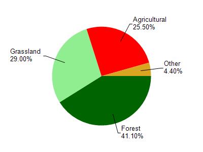
Watershed Characteristics
Seas Branch is located in the West Fork Kickapoo River watershed which is 118.04 mi². Land use in the watershed is primarily forest (41.10%), grassland (29%) and a mix of agricultural (25.50%) and other uses (4.40%). This watershed has 283.75 stream miles, 49.18 lake acres and 672.36 wetland acres.
Nonpoint Source Characteristics
This watershed is ranked High for runoff impacts on streams, Not Ranked for runoff impacts on lakes and High for runoff impacts on groundwater and therefore has an overall rank of High. This value can be used in ranking the watershed or individual waterbodies for grant funding under state and county programs.However, all waters are affected by diffuse pollutant sources regardless of initial water quality. Applications for specific runoff projects under state or county grant programs may be pursued. For more information, go to surface water program grants.