Chippewa
No
No
Yes
Fish and Aquatic Life
Overview
A clean-up plan for Little Lake Wissota in Chippewa County is available for a 30-day public review. The plan sets a level for how much pollution the lake can receive from all sources known as a total maximum daily load, or TMDL and still support appropriate aquatic life and
recreational uses.
Currently, Little Lake Wissota does not meet state or federal water quality standards. The lake exhibits excessive levels of phosphorus during summer months and is subject to algal blooms. Bodycontact recreation during the summer is impaired by poor water quality. Studies show most phosphorus flowing into the lake comes from runoff throughout the 43,194-
acre watershed, which is defined by Stillson and Paint creeks. Most comes from agricultural sources.
Phosphorus is also released from lake sediments under certain conditions.
The state Department of Natural Resources, in conjunction with the Chippewa County Land Conservation Department and a local citizen advisory committee, has developed a TMDL plan for Little Lake Wissota. The TMDL calls for a 34 percent reduction in phosphorus discharges from the watershed
and a 26 percent reduction in sediment discharges. Once the TMDL is approved, an implementation plan will be developed.
Date 2008
Author Aquatic Biologist
Overview
A water quality assessment conducted in Lake Wissota in 1989 found water quality in Moon Bay
and Little Lake Wissota to be poorer than water quality in the main basin of the lake. The cause of
degraded conditions could not be identified from the data collected. Higher nutrient loadings from
runoff pollutants contributed by the Yellow River, Paint Creek, and Stillson Creek are suspected as
the cause of the poorer water quality conditions.
Northern States Power (NSP) currently has a Federal Energy Regulatory Commission (FERC)
license to operate the Wissota hydroelectric power facility with a 15-foot maximum late-winter
drawdown. The ecological impact of this drawdown is not understood and should be addressed as
part of the relicensing process. NSP is currently in the process of relicensing the Lake Wissota
hydropower facility with FERC. The current license expires in 2000.
A U.S Environmental Protection Agency (EPA) Phase I Diagnostic and Feasibility Study, initiated
in 1992, is being conducted on the lake. The study will be completed in 1996. WDNR, Northern
States Power, Chippewa County, and U.S. EPA are jointly funding this study, which includes
watershed land use assessment for the Lower Yellow River Watershed (LC19), water quality
monitoring, bathymetric mapping, hydrologic and nutrient budgets, benthic invertebrate assessment,
fish stranding assessment, and water quality modeling
The main objectives of the study are to determine (1) the cause of degraded water quality conditions
in Little Lake Wissota and Moon Bay and whether they can be controlled, and (2) ecological
impacts from late winter drawdowns on aquatic invertebrates and fish (WDNR 1993). The final
report from this study will be a site-specific water quality management plan for Lake Wissota and
the Lower Yellow River watershed (LC19). The final report and recommendations should be
considered amended to this document as part of the overall water quality management plan for the
Lower Chippewa River basin.
Date 1996
Author Aquatic Biologist
Overview
A study of aquatic plant distribution and density was conducted from 1989 to 1990 on Lake
Wissota. The survey found 22 species of aquatic plants, dominated by drawdown-tolerant species. A
combination of factors contributed to the distribution and density of aquatic plants, including
sediment type, water quality, drawdown impact areas, wave action, and steep slope. It was
concluded that limiting the amount and duration of winter drawdown could have a beneficial effect
on drawdown-sensitive species (Borman Jan. 199 1).
Fish consumption advisories for mercury exist from Holcombe Flowage downstream to the Dells
Dam in Eau Claire. Examination of data indicates that mercury values are similar for Lake Wissota,
Chppewa Flowage, and Old Abe Flowage while similarity exists between Holcombe and Cornell
Flowages. Therefore, Holcombe Flowage and Lake Wissota will be used as surrogates for the system
as all major game species are collected for assessment, including walleye, northern pike, bass,
crappie, flathead and channel catfish. The fish will be tested for both mercury and PCB. Sturgeon
will also be collected, if available, through angler donation, as will carp (Amrhein). Holcombe
Flowage fish collection is addressed in the Upper Chippewa River. Refer to the Chippewa River
Main Stem section of ths plan for additional water quality information about the Chppewa River
system and Lake Wissota.
Lake Wissota State Park is on the northeast shore of Lake Wissota. A slide show titled "Wetlands -
The Land and Water Connection" is shown to visitors of the Wissota State Park Nature Center.
Wetland Adventure Packs containing activities and instructions on laminated sheets, collection and
observation materials (magnifying boxes, nets, containers, etc.) and field guides were developed for a
wetlands education project initiated by the Chippewa County Board of Supervisors and the Land
Conservation Department. These packs can be checked out at the Wissota State Park Nature Center
by families or small groups for use on hikes near wetlands in the park.
Date 1996
Author Aquatic Biologist
Historical Description
A soft water, drainage impoundment on the Chippewa River. It has a 59-foot water control structure on its outlet operated by the Northern States Power Co. It is the largest single body of water in Chippewa County. The most common fish species here are walleyes, northern pike, smallmouth bass, bluegills, black crappies, channel catfish, bullheads, redhorse and white suckers. Other species present include muskellunge, largemouth bass, perch, rock bass, pumpkinseeds, rock sturgeon, quillback and carp. Extreme water level fluctuations are a factor in its management. Ducks and coots numbering in the 10,000's and Canada geese use the lake during migratory seasons. Nesting ducks in the lake area include mallards, blue-winged teal, wood ducks, mergansers and loon. Private development here consists of six resorts, four boat rental places, 600 cottages and dwellings and two organizational camps. There are five park areas on Lake Wissota besides a proposed state recreation
area. They are the Town of Anson park near Jim Falls, Town of Lafayette park - Section 36, a county park development on the east side near the American Legion park on the outlet bay of the Yellow River and a Rod and Gun Club - NSP park near Lake Wissota's outlet. There is also a NSP swimming beach near highway "29". Access to Lake Wissota can be had at the Rod and Gun Club - NSP park, and the American Legion park, an access near the Paint Creek bridge and a public access road without a parking area in the Town of Lafayette, Section 36. A marina off highway "S" also offers access to the lake. There are 30 other platted access roads and paths to the lake, some of which have been marked as such. The total town, county and institutional public frontage is 1.9 miles.Source: 1963, Surface Water Resources of Chippewa County Lake Wissota T28, 29N, R8W, Sections 26, etc. Surface Acres = 6,300, S.D.F. = 5.23, Maximum Depth = 72 feet
Date 1963
Author Surface Water Inventory Of Wisconsin
Recommendations
APM Chemical Permit Request
TMDL Implementation
EPA has determined that Wisconsin's TMDLs for phosphorus and sediment meet the requirements of Section 303(d) of the Clean Water Act and EPA's implementing regulations set forth at 40 CFR Part 130. EPA approves one TMDL for phosphorus and one TMDL for sediment addressing two impairments in Little Lake Wissota.
Implementation Plan is needed.
TMDL (USEPA) Approved
EPA has determined that Wisconsin's TMDLs for phosphorus and sediment meet the requirements of Section 303(d) of the Clean Water Act and EPA's implementing regulations set forth at 40 CFR Part 130. EPA approves one TMDL for phosphorus and one TMDL for sediment addressing two impairments in Little Lake Wissota.
TMDL Implementation
Little Lake Wissota is a 400-acre eutrophic embayment of Lake Wissota, an impoundment of the Chippewa River near Chippewa Falls, Wisconsin (Hydrologic Unit Code 07050005, Wisconsin Waterbody Identification Code 2152800). The embayment has a maximum depth of 43 feet and a drainage area of approximately 67 square miles. Paint Creek is the primary source of surface water inflow to Little Lake Wissota. The Little Lake Wissota watershed is located in the North Central Hardwood Forest Ecoregion (Omernick and Gallant, 1988). This EPA Ecoregion is characterized by nearly level to rolling glacial till plains, significant agricultural land use and lakes with phosphorus concentrations greater than 50 ppb, indicative of eutrophic conditions. The lake was placed on the Wisconsin 303(d) impaired waters list in 1998 with a high priority ranking due to eutrophication and pH criteria exceedances. In addition, recreational uses are limited during the summer due to poor water quality from excess phosphorus (P) and sediment loading. Land cover in the watershed is primarily agricultural and forest. The goal of this TMDL is to reduce levels of phosphorus and sediment loading and decrease the extent and severity of summer algal blooms in Little Lake Wissota.
TMDL Implementation
Little Lake Wissota (South Bay on Lake Wissota) Listed for pH, eutrophication (sediment and total phosphorus). TMDL submitted to USEPA for approval in 2010..
Management Goals
Wisconsin's Water Quality Standards provide qualitative and quantitative goals for waters that are protective of Fishable, Swimmable conditions [Learn more]. Waters that do not meet water quality standards are considered impaired and restoration actions are planned and carried out until the water is once again fishable and swimmable
Management goals can include creation or implementation of a Total Maximum Daily Load analysis, a Nine Key Element Plan, or other restoration work, education and outreach and more. If specific recommendations exist for this water, they will be displayed below online.
Monitoring
Monitoring the condition of a river, stream, or lake includes gathering physical, chemical, biological, and habitat data. Comprehensive studies often gather all these parameters in great detail, while lighter assessment events will involve sampling physical, chemical and biological data such as macroinvertebrates. Aquatic macroinvertebrates and fish communities integrate watershed or catchment condition, providing great insight into overall ecosystem health. Chemical and habitat parameters tell researchers more about human induced problems including contaminated runoff, point source dischargers, or habitat issues that foster or limit the potential of aquatic communities to thrive in a given area. Wisconsin's Water Monitoring Strategy was recenty updated.
Grants and Management Projects
Monitoring Projects
| WBIC | Official Waterbody Name | Station ID | Station Name | Earliest Fieldwork Date | Latest Fieldwork Date | View Station | View Data |
|---|
| 2152800 | Lake Wissota | 10042275 | Lake Wissota - Mid Lake S End | 8/4/2014 | 8/14/2019 | Map | Data |
| 2152800 | Lake Wissota | 10018389 | Lake Wissota -- Access - Near County Highway X | 9/21/2004 | 8/27/2023 | Map | Data |
| 2152800 | Lake Wissota | 093176 | Lake Wissota - North Side | | | Map | Data |
| 2152800 | Lake Wissota | 10028964 | Lake Wissota -- Access At Hwy S | 5/28/2008 | 8/27/2023 | Map | Data |
| 2152800 | Lake Wissota | 093098 | Lake Wissota - 350' Of Hydro Dam | 1/17/1989 | 7/25/2002 | Map | Data |
| 2152800 | Lake Wissota | 10015091 | Wissota Lake 2003-Lake Sturgeon Data Below Jim Falls Hydro | | | Map | Data |
| 2152800 | Lake Wissota | 093119 | Lake Wissota - Far Dam | 8/6/1992 | 5/1/1994 | Map | Data |
| 2152800 | Lake Wissota | 093125 | Lake Wissota - Deep Hole - North | 7/11/1990 | 9/8/2015 | Map | Data |
| 2152800 | Lake Wissota | 093131 | Lake Wissota - Deep Spot Near Chippewa River Inflow / Se Bridge Hwy S | 5/18/2003 | 6/11/2016 | Map | Data |
| 2152800 | Lake Wissota | 093118 | Lake Wissota - Near Dam | 7/28/1992 | 4/22/1994 | Map | Data |
| 2152800 | Lake Wissota | 088 | Chippewa Lake Wissota - Chippewa Lake Wissota | 5/12/1977 | 5/12/1977 | Map | Data |
| 2152800 | Lake Wissota | 10001052 | Lake Wissota | 8/7/1989 | 4/12/2023 | Map | Data |
| 2152800 | Lake Wissota | 093010 | Chippewa River - Falls Dairy Co Jim Falls | 5/4/1977 | 5/15/1984 | Map | Data |
| 2152800 | Lake Wissota | 093097 | Lake Wissota-Little Lake Wissota - Bridge | 1/17/1989 | 10/23/1990 | Map | Data |
| 2152800 | Lake Wissota | 094012 | Wissota L. - Wissota L. | 8/27/1979 | 8/27/1979 | Map | Data |
| 2152800 | Lake Wissota | 093168 | Lake Wissota - Site 1 - Paint Creek - South | 6/24/1990 | 10/9/2003 | Map | Data |
| 2152800 | Lake Wissota | 093160 | Lake Wissota - Mouth Of Moon Bay | 6/13/2001 | 6/11/2016 | Map | Data |
| 2152800 | Lake Wissota | 10029006 | Lake Wissota -- Access - Chippewa Rod and Gun Club | 6/1/2008 | 9/30/2023 | Map | Data |
| 2152800 | Lake Wissota | 093132 | Wissota Lake - NE Of Dam | | | Map | Data |
| 2152800 | Lake Wissota | 093161 | Lake Wissota - Mouth Of L.L. Wissota | 6/13/2001 | 8/22/2013 | Map | Data |
| 2152800 | Lake Wissota | 093099 | Lake Wissota - Near Yacht Club End Hwy S Bridge | 1/17/1989 | 11/1/1989 | Map | Data |
| 2152800 | Lake Wissota | 093105 | Lake Wissota - Mid Lake N End | 8/4/2014 | 9/2/2019 | Map | Data |
| 2152800 | Lake Wissota | 10014916 | Lake Wissota | | | Map | Data |
|
Watershed Characteristics
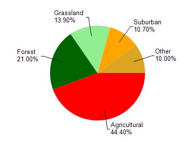
Lake Wissota is located in the Duncan Creek watershed which is 191.44 mi². Land use in the watershed is primarily agricultural (44.40%), forest (21%) and a mix of grassland (13.90%) and other uses (20.70%). This watershed has 270.37 stream miles, 185.45 lake acres and 6,971.50 wetland acres.
Nonpoint Source Characteristics
This watershed is ranked Not Available for runoff impacts on streams, Not Available for runoff impacts on lakes and High for runoff impacts on groundwater and therefore has an overall rank of High. This value can be used in ranking the watershed or individual waterbodies for grant funding under state and county programs.This water is ranked High Lake for individual Unknowns based on runoff problems and the likelihood of success from project implementation.