Douglas
Yes
Yes
No
Fish and Aquatic Life
Overview
The Bois Brule River has a renowned fishery. The original fishery contained stream-resident and migratory (coaster) strains of brook trout. The migratory strain of brook trout was extirpated by the early 1900s. The river now supports, in addition to resident brook trout, both resident and migratory strains of brown trout and migratory strains of rainbow trout, coho and chinook salmon (Pratt 1996). Migratory rainbow trout spawning runs occur in spring and fall, while other species migrate from the lake in summer and fall.
Historically, the Bois Brule, along with the Bad River, produced about 85 percent of the sea lamprey captured at lamprey weirs. The influence of this exotic species is blamed in part for the crash of the Lake Superior trout fishery in the 1950s and 1960s. The lamprey are estimated to account for 375,000 pounds of the estimated 600,000 lake trout taken from Lake Superior annually (Fisheries Management). In 1985, a combination sea lamprey barrier/fishway was installed about six miles upstream from the mouth, effectively eliminating lamprey spawning above that point and preventing the need for electrical or chemical controls. The barrier has a sub-surface observation window that has helped managers collect a great deal of data. More than 7,000 lamprey were trapped and removed during the 1986 spawning season. By 1995, lamprey catches at the Brule barrier had steeply declined.
Under the Lake Superior Binational Program, the Brule River became a demonstration site for best-management practices to control runoff. WDNR and the Douglas County Land Conservation Department received grants that allowed the demonstration of construction and soil stabilization techniques to reduce roadside ditch erosion and protect stream habitat. Natural drainage patterns were restored to reduce dramatic erosion and highway maintenance problems that had plagued the County Highway FF crossing for years. The project expanded a pond managed for wildlife habitat and protected valuable aquatic habitat in the Brule.
An accelerated soils survey for the Brule River State Forest has assisted forest managers in the development of a state forest master plan and is a tool being used as part of the National Hierarchy of Ecological Units for determining the potential natural vegetation that could be supported if the forest was allowed to progress through natural succession to maturity.
High levels of bacteria in the river near the community of Brule from failing septic systems led to the formation of the Brule Sanitary District No. 1, which discharges to groundwater in the watershed.
During survey work conducted as part of the coastal wetlands evaluation, no rare species of macroinvertebrate were found and the overall taxa richness was moderate (5-24 species) (Epstein 1997). The survey noted some turbidity and filamentous algae at the survey site.
From: Turville-Heitz, Meg. 1999. Lake Superior Basin Water Quality Management Plan. Wisconsin Department of Natural Resources, Madison, WI.
Date 1999
Author Aquatic Biologist
General Condition
Bois Brule River was assessed during the 2018 listing cycle; new total phosphorus and chloride sample data were clearly below the 2018 WisCALM listing thresholds for the Fish and Aquatic Life use. This water was meeting this designated use and was not considered impaired.
Date 2017
Author Ashley Beranek
Condition
Wisconsin has over 84,000 miles of streams, 15,000 lakes and milllions of acres of wetlands. Assessing the condition of this vast amount of water is challenging. The state's water monitoring program uses a media-based, cross-program approach to analyze water condition. An updated monitoring strategy (2015-2020) is now available. Compliance with Clean Water Act fishable, swimmable standards are located in the Executive Summary of Water Condition in 2018. See also the 'monitoring and projects' tab.
Reports
Management Goals
Wisconsin's Water Quality Standards provide qualitative and quantitative goals for waters that are protective of Fishable, Swimmable conditions [Learn more]. Waters that do not meet water quality standards are considered impaired and restoration actions are planned and carried out until the water is once again fishable and swimmable
Management goals can include creation or implementation of a Total Maximum Daily Load analysis, a Nine Key Element Plan, or other restoration work, education and outreach and more. If specific recommendations exist for this water, they will be displayed below online.
Monitoring
Monitoring the condition of a river, stream, or lake includes gathering physical, chemical, biological, and habitat data. Comprehensive studies often gather all these parameters in great detail, while lighter assessment events will involve sampling physical, chemical and biological data such as macroinvertebrates. Aquatic macroinvertebrates and fish communities integrate watershed or catchment condition, providing great insight into overall ecosystem health. Chemical and habitat parameters tell researchers more about human induced problems including contaminated runoff, point source dischargers, or habitat issues that foster or limit the potential of aquatic communities to thrive in a given area. Wisconsin's Water Monitoring Strategy was recenty updated.
Grants and Management Projects
Monitoring Projects
| WBIC | Official Waterbody Name | Station ID | Station Name | Earliest Fieldwork Date | Latest Fieldwork Date | View Station | View Data |
|---|
| 2861800 | Bois Brule River | 10047724 | Brule River Nonwadeable IBI 1.2 Mi US of mouth | | | Map | Data |
| 2861800 | Bois Brule River | 150 | Brule River - Brule R-T49n R10w S10 | 7/21/1970 | 7/21/1970 | Map | Data |
| 2868600 | Big Lake | 10053714 | Bois Brule River DS Lucius Lake | 7/2/2019 | 7/2/2019 | Map | Data |
| 2861800 | Bois Brule River | 163214 | Bois Brule River - Boat Landing Site 3 | 6/28/1990 | 6/15/2021 | Map | Data |
| 2868300 | Spring Lake | 10036198 | Bois Brule River - Area of Open Water | 6/29/2010 | 8/30/2012 | Map | Data |
| 2861800 | Bois Brule River | 10013275 | Bois Brule River- 609 Meters Downstream Hwy S- Station #2 | | | Map | Data |
| 2861800 | Bois Brule River | 10050690 | Brule River Range Rd to Nebagamon Cr | 6/16/2016 | 10/13/2022 | Map | Data |
| 2861800 | Bois Brule River | 10019662 | Bois Brule River -- Stone Chimney Canoe Launch | 7/29/2023 | 7/29/2023 | Map | Data |
| 2861800 | Bois Brule River | 10042846 | Bois Brule River at Ranger Station | 9/13/2014 | 6/28/2023 | Map | Data |
| 2861800 | Bois Brule River | 10050693 | Brule River Hwy B to Spring Lake | 6/16/2016 | 6/16/2016 | Map | Data |
| 2861800 | Bois Brule River | 163056 | Brule River at Sth 2 | | | Map | Data |
| 2861800 | Bois Brule River | 163058 | Brule River at Cth Ff | 7/29/2019 | 7/14/2020 | Map | Data |
| 2861800 | Bois Brule River | 163216 | Bois Brule River - Boat Landing | | | Map | Data |
| 2861800 | Bois Brule River | 163002 | Bois Brule River at STH 13 | 6/27/1973 | 4/10/2024 | Map | Data |
| 2861800 | Bois Brule River | 163213 | Bois Brule River - Above Mouth Site 2 | 6/28/1990 | 6/28/1990 | Map | Data |
| 2861800 | Bois Brule River | 10047341 | Bois Brule River - Cedar Island | 1/1/2015 | 1/1/2015 | Map | Data |
| 2861800 | Bois Brule River | 163062 | Brule River at Cth S | 9/23/2009 | 8/17/2019 | Map | Data |
| 2868300 | Spring Lake | 10019066 | Bois Brule River -- Highway 13 Canoe Landing | 8/20/2005 | 7/31/2020 | Map | Data |
| 2861800 | Bois Brule River | 163212 | Bois Brule River - State Park Hq Site 1 | 6/28/1990 | 7/20/2016 | Map | Data |
| 2861800 | Bois Brule River | 163304 | Bois Brule River at Riverview Dr | 9/26/2011 | 1/1/2015 | Map | Data |
| 2861800 | Bois Brule River | 10020184 | Bois Brule River -- Pine Tree Canoe Landing | 6/30/2007 | 10/17/2013 | Map | Data |
| 2861800 | Bois Brule River | 10018753 | Boise Brule River -- Winneboujou Canoe Launch | 5/31/2008 | 1/1/2015 | Map | Data |
| 2861800 | Bois Brule River | 10049153 | Brule River US 1.25M of mouth | 1/1/2015 | 1/1/2015 | Map | Data |
| 2861800 | Bois Brule River | 163409 | Bois Brule River at Brule WI | 8/15/1991 | 11/17/2003 | Map | Data |
| 2861800 | Bois Brule River | 10042844 | Bois Brule River at Copper Range Campground | 9/13/2014 | 7/11/2019 | Map | Data |
| 2861800 | Bois Brule River | 105 | Lake Superior - Mouth Brule River | 7/17/1974 | 8/10/1993 | Map | Data |
| 2861800 | Bois Brule River | 10019061 | Boise Brule River -- Highway 2 Canoe Landing | 6/28/2009 | 5/24/2023 | Map | Data |
| 2861800 | Bois Brule River | 10019724 | Bois Brule River -- Canoe Landing | 6/4/2011 | 11/7/2013 | Map | Data |
| 2861800 | Bois Brule River | 10050735 | Brule River-Trask Creek to Saari's lot | 6/14/2016 | 6/14/2016 | Map | Data |
| 2861800 | Bois Brule River | 10047924 | Bois Brule River - HWY FF | 11/7/2013 | 11/7/2013 | Map | Data |
| 2868600 | Big Lake | 10052618 | Bois Brule River at Lucius Lake | | | Map | Data |
| 2861800 | Bois Brule River | 163222 | Bois Brule River - Stones Bridge | 5/14/1991 | 6/27/2023 | Map | Data |
| 2861800 | Bois Brule River | 10052618 | Bois Brule River at Lucius Lake | | | Map | Data |
| 2861800 | Bois Brule River | 10052620 | Bois Brule River South of Cedar Island | 7/2/2019 | 7/2/2019 | Map | Data |
| 2861800 | Bois Brule River | 10020185 | Bois Brule River -- Copper Range Campground | 8/28/2010 | 7/11/2019 | Map | Data |
| 2861800 | Bois Brule River | 10036169 | Bois Brule River - Area of Open Water | | | Map | Data |
| 2861800 | Bois Brule River | 10031262 | Bois Brule Winneboujou Club Bridge to Cutler Creek mouth | 1/1/2015 | 8/10/2023 | Map | Data |
| 2861800 | Bois Brule River | 10047926 | Bois Brule River - Town Park Rd Landing | 11/7/2013 | 11/7/2013 | Map | Data |
| 2861800 | Bois Brule River | 10019062 | Bois Brule River -- Stone Bridge Canoe Access | 11/7/2013 | 11/7/2013 | Map | Data |
| 2861800 | Bois Brule River | 10050692 | Brule River Nebagamon Cr to Hwy B | 6/6/2016 | 6/6/2016 | Map | Data |
| 2861800 | Bois Brule River | 163055 | Brule River at Cth B | 6/9/1979 | 1/1/2015 | Map | Data |
| 2861800 | Bois Brule River | 165044 | Bois Brule River - Downstream Of Highway 2 | 4/17/2001 | 4/17/2001 | Map | Data |
| 2861800 | Bois Brule River | 10052621 | Bois Brule River US confluence Unnamed (2868200) | | | Map | Data |
| 2861800 | Bois Brule River | 10050695 | Brule River Utilities ROW (east) | 6/26/2015 | 6/26/2015 | Map | Data |
| 2861800 | Bois Brule River | 10053714 | Bois Brule River DS Lucius Lake | 7/2/2019 | 7/2/2019 | Map | Data |
| 2861800 | Bois Brule River | 10036198 | Bois Brule River - Area of Open Water | 6/29/2010 | 8/30/2012 | Map | Data |
| 2861800 | Bois Brule River | 10013273 | Bois Brule River- Upstream At Pine Tree Canoe Landing- Station #1 | 6/28/2022 | 7/17/2023 | Map | Data |
| 2861800 | Bois Brule River | 10042842 | Bois Brule River at Co Rd B | 9/13/2014 | 6/15/2022 | Map | Data |
|
Watershed Characteristics
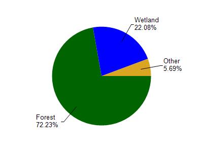
Bois Brule River is located in the Bois Brule River watershed which is 199.64 mi². Land use in the watershed is primarily forest (72.30%), wetland (22.10%) and a mix of grassland (3.40%) and other uses (2.30%). This watershed has 220.94 stream miles, 3,539.94 lake acres and 18,373.66 wetland acres.
Nonpoint Source Characteristics
This watershed is ranked Not Ranked for runoff impacts on streams, Not Available for runoff impacts on lakes and Low for runoff impacts on groundwater and therefore has an overall rank of Low. This value can be used in ranking the watershed or individual waterbodies for grant funding under state and county programs.However, all waters are affected by diffuse pollutant sources regardless of initial water quality. Applications for specific runoff projects under state or county grant programs may be pursued. For more information, go to surface water program grants.