Bayfield
Yes
No
No
Fish and Aquatic Life
Overview
This cold water stream originates in Iron Lake, flows through the Iron River Flowage (Mill Pond Lake) at the town of Iron River and the Orienta Flowage before emptying into Lake Superior. At one time, the Iron River Sanitary District discharged to the river, but now discharges to groundwater via a seepage cell. High quality spring water reaches the river from a number of sources, including Mud Lake. District files indicate Dahlberg Light and Power Company operated a hydro project on the Iron River at the Iron River Flowage, a 76-acre impoundment formed by a concrete roller dam with 23-foot head. Power is no longer generated at this project and the town of Iron River now maintains the flowage.
A 44-foot overflow dam once formed the Orienta Flowage and is now in the process of being abandoned. Northern States Power operated the Orienta Hydro Project until 1985 when the dam washed out for the second time during a heavy storm when the flooding river overtopped the embankments. Dam failure was attributed to a spillway clogged with debris and the inability to reach and open the gates in time. The original dam, built in 1922, washed out in 1946, when the project moved about 60 feet downstream from the original location and with a higher head to give it more generating capacity.
The Federal Energy Regulatory Commission (FERC), which licenses hydropower operations, in 1989 accepted Northern States Power's surrender of its hydropower license due to operating costs at this site (Scheirer). Since the dam is no longer licensed, Northern States Power is working with WDNR to properly abandon the operation. Part of the process involved collecting sediment samples from the flowage behind the dam to determine if any contamination existed. In 1995, a consultant for the company mapped and sampled the sediments that collected behind the dam during its operation. Sediment contour mapping indicated to the consulting engineers that the present river channel does not currently follow its original path and is much shallower. It is expected that after dam removal, the stream will erode a new, more stable channel through the sediment. Mapping estimated that 235 acre-feet of sediment had been deposited behind the dam, averaging a depth of a little more than 4 feet over the 52 acres of reservoir area analyzed. Analysis of sediment samples taken from the dam by WDNR and the consultant resulted in contaminant levels typical of the region and did not indicate a specific contaminant problem.
Not unlike many other communities in the state, dam abandonment and removal has raised local concerns about what will happen to the river after the dam is gone, or if not removed, who will take responsibility for dam maintenance. WDNR has met with the public on the issue, which is presently in the hands of an administrative law judge (Tomasko).
The lower Iron River is fringed with wetlands and supports an exceptional fishery of brook, brown and rainbow trout, several warm water species, burbot and lake sturgeon. The upper reach, above the confluence with Muskeg Creek, is considered Class II trout waters. The portion from Muskeg Creek to the Orienta Dam has been considered Class III trout waters.
From: Turville-Heitz, Meg. 1999. Lake Superior Basin Water Quality Management Plan. Wisconsin Department of Natural Resources, Madison, WI.
Date 1999
Author Aquatic Biologist
General Condition
Iron River (WBIC 2872000) was assessed during the 2018 listing cycle; new total phosphorus and biological (macroinvertebrate Index of Biotic Integrity (IBI) scores) sample data were clearly below the 2018 WisCALM listing thresholds for the Fish and Aquatic Life use. This water was meeting this designated use and was not considered impaired.
Date 2017
Author Ashley Beranek
Condition
Wisconsin has over 84,000 miles of streams, 15,000 lakes and milllions of acres of wetlands. Assessing the condition of this vast amount of water is challenging. The state's water monitoring program uses a media-based, cross-program approach to analyze water condition. An updated monitoring strategy (2015-2020) is now available. Compliance with Clean Water Act fishable, swimmable standards are located in the Executive Summary of Water Condition in 2018. See also the 'monitoring and projects' tab.
Reports
Recommendations
Lake Management Plan Development
BAYFIELD COUNTY: Protecting the Iron River/Delta Lakes through Education, Prevention, Containment & Planning
Management Goals
Wisconsin's Water Quality Standards provide qualitative and quantitative goals for waters that are protective of Fishable, Swimmable conditions [Learn more]. Waters that do not meet water quality standards are considered impaired and restoration actions are planned and carried out until the water is once again fishable and swimmable
Management goals can include creation or implementation of a Total Maximum Daily Load analysis, a Nine Key Element Plan, or other restoration work, education and outreach and more. If specific recommendations exist for this water, they will be displayed below online.
Monitoring
Monitoring the condition of a river, stream, or lake includes gathering physical, chemical, biological, and habitat data. Comprehensive studies often gather all these parameters in great detail, while lighter assessment events will involve sampling physical, chemical and biological data such as macroinvertebrates. Aquatic macroinvertebrates and fish communities integrate watershed or catchment condition, providing great insight into overall ecosystem health. Chemical and habitat parameters tell researchers more about human induced problems including contaminated runoff, point source dischargers, or habitat issues that foster or limit the potential of aquatic communities to thrive in a given area. Wisconsin's Water Monitoring Strategy was recenty updated.
Grants and Management Projects
Monitoring Projects
| WBIC | Official Waterbody Name | Station ID | Station Name | Earliest Fieldwork Date | Latest Fieldwork Date | View Station | View Data |
|---|
| 2872000 | Iron River | 10007903 | Iron River Main St. Station # 3 | 1/1/2015 | 1/1/2015 | Map | Data |
| 2872000 | Iron River | 10038131 | Iron River 170' US Sorenson Rd | 6/11/2012 | 7/3/2018 | Map | Data |
| 2872200 | Orienta Flowage | 10000984 | Orienta Flowage | 9/5/2000 | 9/5/2000 | Map | Data |
| 2872000 | Iron River | 10029293 | Iron River ~100 Meters upstream of Orienta Falls | 10/8/2008 | 6/26/2020 | Map | Data |
|
Watershed Characteristics
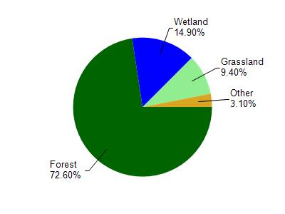
Iron River is located in the Iron River watershed which is 213.39 mi². Land use in the watershed is primarily forest (72.60%), wetland (14.90%) and a mix of grassland (9.40%) and other uses (3.10%). This watershed has 300.83 stream miles, 5,975.89 lake acres and 7,470.27 wetland acres.
Nonpoint Source Characteristics
This watershed is ranked Not Ranked for runoff impacts on streams, Not Available for runoff impacts on lakes and Low for runoff impacts on groundwater and therefore has an overall rank of Low. This value can be used in ranking the watershed or individual waterbodies for grant funding under state and county programs.However, all waters are affected by diffuse pollutant sources regardless of initial water quality. Applications for specific runoff projects under state or county grant programs may be pursued. For more information, go to surface water program grants.