Bayfield
Yes
No
No
Fish and Aquatic Life
Overview
The Siskiwit River originates in Siskiwit Lake and flows through Little Siskiwit Lake, before emptying into Siskiwit Bay on Lake Superior. From the outlet of Siskiwit Lake downstream to Siskiwit Springs in T50N R6W S24, the water quality is characterized by high temperatures, acid pH and dark brown color. This river reach supports primarily forage species. From the springs, water quality improves and allows trout survival. For the five-mile stretch from the springs to Siskiwit Falls, the river is classified as Class I trout water for brook, brown and rainbow trout. This segment of river is also considered an exceptional resource water. Below the falls to the mouth, the stream is Class II trout water because of its lack of gravel spawning areas. Rainbow and brown trout, and chinook and coho salmon migrate from the lake to spawn. The river also supports spawning northern pike, bullheads, suckers and spottail shiners.
At the mouth of the river, Cornucopia Harbor provides a mooring and docking area for commercial and sport fishing operations and private recreation. A pier juts out from the mouth, forming a sheltered beach area. Sediment sampling in the harbor since the last update of this plan did not indicate contaminants at levels higher than background typical of the region.
Siskiwit Bay is bounded by Squaw Point to the east and Roman Point to the west. The bay is a spawning area for lake whitefish. Shorebirds use the sand beaches of the bay. The mouth of the river, the bay shoreline and Roman Point are in private ownership. Upstream areas of the Siskiwit River are in county forest and private ownership. The Lake Superior Binational Program identified Siskiwit Bay and the river as important to the integrity of the Lake Superior ecosystem for fish and wildlife spawning and nursery grounds.
Past water quality sampling by the University of Wisconsin - Superior, indicated fecal coliform counts were elevated. This was prior to the construction of the new Bell Sanitary District Wastewater Treatment Plant.
A tributary to Siskiwit Bay entering the lake at T51N R6W S34 has been designated an exceptional resource water. This stream is listed as a Class I trout stream for brook trout in Wisconsin Trout Streams. We have little other information for this stream.
From: Turville-Heitz, Meg. 1999. Lake Superior Basin Water Quality Management Plan. Wisconsin Department of Natural Resources, Madison, WI.
Date 1999
Author Aquatic Biologist
Impaired Waters
Siskiwit River (2881900) Assessment Unit 19008. This water should not be listed as impaired. It is still "unassessed" as the fish survey Sequence # 91435 used too few fish. This no longer has a stand-alone biology assessment.?
Date 2014
Author Aquatic Biologist
Condition
Wisconsin has over 84,000 miles of streams, 15,000 lakes and milllions of acres of wetlands. Assessing the condition of this vast amount of water is challenging. The state's water monitoring program uses a media-based, cross-program approach to analyze water condition. An updated monitoring strategy (2015-2020) is now available. Compliance with Clean Water Act fishable, swimmable standards are located in the Executive Summary of Water Condition in 2018. See also the 'monitoring and projects' tab.
Reports
Recommendations
Monitor Fish Community
Don't list as Category 5A - leave as Category 3. Fish Survey Sequence # 91435 used too few fish. This no longer has a stand-alone biology assessment.
Management Goals
Wisconsin's Water Quality Standards provide qualitative and quantitative goals for waters that are protective of Fishable, Swimmable conditions [Learn more]. Waters that do not meet water quality standards are considered impaired and restoration actions are planned and carried out until the water is once again fishable and swimmable
Management goals can include creation or implementation of a Total Maximum Daily Load analysis, a Nine Key Element Plan, or other restoration work, education and outreach and more. If specific recommendations exist for this water, they will be displayed below online.
Monitoring
Monitoring the condition of a river, stream, or lake includes gathering physical, chemical, biological, and habitat data. Comprehensive studies often gather all these parameters in great detail, while lighter assessment events will involve sampling physical, chemical and biological data such as macroinvertebrates. Aquatic macroinvertebrates and fish communities integrate watershed or catchment condition, providing great insight into overall ecosystem health. Chemical and habitat parameters tell researchers more about human induced problems including contaminated runoff, point source dischargers, or habitat issues that foster or limit the potential of aquatic communities to thrive in a given area. Wisconsin's Water Monitoring Strategy was recenty updated.
Grants and Management Projects
Monitoring Projects
| WBIC | Official Waterbody Name | Station ID | Station Name | Earliest Fieldwork Date | Latest Fieldwork Date | View Station | View Data |
|---|
| 2881900 | Siskiwit River | 10019625 | Lake Superior -- Bell Marina Cornucopia Access | 8/15/2008 | 9/7/2025 | Map | Data |
| 2881900 | Siskiwit River | 10032650 | Siskiwit River at Hwy 13 | | | Map | Data |
| 2881900 | Siskiwit River | 10038058 | Lake Superior Bell Marina | 10/16/2012 | 9/12/2013 | Map | Data |
|
Watershed Characteristics
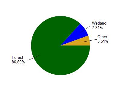
Siskiwit River is located in the Bayfield Peninsula Northwest watershed which is 236.05 mi². Land use in the watershed is primarily forest (86.60%), wetland (7.80%) and a mix of grassland (4.60%) and other uses (0.90%). This watershed has 473.06 stream miles, 43,216.55 lake acres and 6,677.27 wetland acres.
Nonpoint Source Characteristics
This watershed is ranked Not Ranked for runoff impacts on streams, Not Available for runoff impacts on lakes and Low for runoff impacts on groundwater and therefore has an overall rank of Low. This value can be used in ranking the watershed or individual waterbodies for grant funding under state and county programs.However, all waters are affected by diffuse pollutant sources regardless of initial water quality. Applications for specific runoff projects under state or county grant programs may be pursued. For more information, go to surface water program grants.