Bayfield
Yes
Yes
No
Fish and Aquatic Life
Overview
This medium-sized Class I trout stream is an outstanding resource water for its entire length. The stream drains about 30 square miles, dropping some 400 feet before entering Lake Superior. This results in massive erosion problems with historic cases of devastating flash floods. Streambank improvements performed by the Bureau of Fisheries Management have helped enhance spawning habitat for migratory trout and salmon species including rainbow trout, coho and chinook salmon. This stream supports a population of brook, brown and rainbow trout and trout and salmon species from Lake Superior migrate upstream to spawn. The stream's major tributary is North Pikes Creek, but the majority of Pikes Creek baseflow comes from bank springs. WDNR's Bayfield Fish Hatchery discharges well and lake water from the hatchery into Pikes Creek via a small tributary.
Most of the Pikes Creek watershed is upland forest that may periodically be subjected to clearcutting and logging traffic. Some reaches drain heavy red clay soils, while the rest of the stream drains sandy loam soils. Some areas of the watershed are managed as apple orchards. Where Pikes Creek enters Lake Superior, a wetland community supports both emergent and submergent aquatic plants. Offshore in Chequamegon Bay, a large open-water submergent aquatic plant community exists. The area also has sheltered vegetated sand and mud flats. The stream and its estuary provide nesting areas for waterfowl and are used by migratory birds. Lake Superior Village is a marina operating just north of the mouth of Pikes Creek in an area of sheltered flats and vegetation. Both state and private ownership exist along Pikes Creek, but the stream flows through a corridor of land that is largely state owned. This stream is part of the South Shore Fish and Wildlife Area, where there is a state acquisition goal of 1,128 acres.
The mouths of Pikes Creek and Pikes Creek Slough have been identified by the Lake Superior Binational Program as important to the integrity of the Lake Superior ecosystem for coastal wetlands, vital functions for planning objectives, fish and wildlife spawning and nursery grounds. During survey work conducted as part of the coastal wetlands evaluation, one rare species of macroinvertebrate was found and overall taxa richness was moderate (5-24 species) (Epstein 1997). Significant bank erosion, point sources and silt affect habitat quality in the stream and impoundment may pose a threat (Epstein 1997).
Date 1999
Author Aquatic Biologist
Condition
Wisconsin has over 84,000 miles of streams, 15,000 lakes and milllions of acres of wetlands. Assessing the condition of this vast amount of water is challenging. The state's water monitoring program uses a media-based, cross-program approach to analyze water condition. An updated monitoring strategy (2015-2020) is now available. Compliance with Clean Water Act fishable, swimmable standards are located in the Executive Summary of Water Condition in 2018. See also the 'monitoring and projects' tab.
Reports
Management Goals
Wisconsin's Water Quality Standards provide qualitative and quantitative goals for waters that are protective of Fishable, Swimmable conditions [Learn more]. Waters that do not meet water quality standards are considered impaired and restoration actions are planned and carried out until the water is once again fishable and swimmable
Management goals can include creation or implementation of a Total Maximum Daily Load analysis, a Nine Key Element Plan, or other restoration work, education and outreach and more. If specific recommendations exist for this water, they will be displayed below online.
Monitoring
Monitoring the condition of a river, stream, or lake includes gathering physical, chemical, biological, and habitat data. Comprehensive studies often gather all these parameters in great detail, while lighter assessment events will involve sampling physical, chemical and biological data such as macroinvertebrates. Aquatic macroinvertebrates and fish communities integrate watershed or catchment condition, providing great insight into overall ecosystem health. Chemical and habitat parameters tell researchers more about human induced problems including contaminated runoff, point source dischargers, or habitat issues that foster or limit the potential of aquatic communities to thrive in a given area. Wisconsin's Water Monitoring Strategy was recenty updated.
Grants and Management Projects
| Project Name (Click for Details) | Year Started |
|---|
|
|
Monitoring Projects
| WBIC | Official Waterbody Name | Station ID | Station Name | Earliest Fieldwork Date | Latest Fieldwork Date | View Station | View Data |
|---|
| 2884500 | Pikes Creek | 10043093 | Pikes Creek - off Star Route Rd | 1/1/2015 | 1/1/2015 | Map | Data |
| 2884500 | Pikes Creek | 10050802 | Meadow N of Pikes Creek | 7/25/2012 | 7/26/2012 | Map | Data |
| 2884600 | Birch Run | 10058181 | Salmo Lake Walk Trail | 7/13/2023 | 7/13/2023 | Map | Data |
| 2884500 | Pikes Creek | 10013528 | Pikes Creek- Upstream From Dam By Hatchery- Station #1 | 10/13/2010 | 10/6/2020 | Map | Data |
| 2884500 | Pikes Creek | 043005 | Pike Creek - Wdnr Bayfield Fish Hatchery | 11/1/1976 | 7/5/2018 | Map | Data |
| 2884500 | Pikes Creek | 10050804 | Meadow N of Pikes Creek near Birch Run | 7/25/2012 | 7/25/2012 | Map | Data |
| 2884500 | Pikes Creek | 10043094 | Pikes Creek - off Star Route Rd DS of confl w/ Unnamed Cr 24-8 | 1/1/2015 | 1/1/2015 | Map | Data |
| 2884500 | Pikes Creek | 10032642 | Pikes Creek at 1.2 miles SW of Bayfield | | | Map | Data |
| 2884500 | Pikes Creek | 10043095 | Pikes Creek - US from confluence w/ N Pikes Cr | 1/1/2015 | 1/1/2015 | Map | Data |
| 2884500 | Pikes Creek | 10058181 | Salmo Lake Walk Trail | 7/13/2023 | 7/13/2023 | Map | Data |
|
Watershed Characteristics
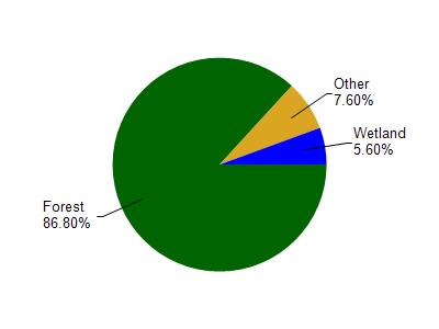
Pikes Creek is located in the Bayfield Peninsula Southeast watershed which is 301.48 mi². Land use in the watershed is primarily forest (86.80%), wetland (5.60%) and a mix of grassland (4.10%) and other uses (3.50%). This watershed has 453.79 stream miles, 291,749.17 lake acres and 6,560.31 wetland acres.
Nonpoint Source Characteristics
This watershed is ranked Not Ranked for runoff impacts on streams, Not Available for runoff impacts on lakes and Low for runoff impacts on groundwater and therefore has an overall rank of Low. This value can be used in ranking the watershed or individual waterbodies for grant funding under state and county programs.However, all waters are affected by diffuse pollutant sources regardless of initial water quality. Applications for specific runoff projects under state or county grant programs may be pursued. For more information, go to surface water program grants.