Iowa
No
No
No
Fish and Aquatic Life
Overview
Rush Creek (WBIC: 1240100) is a 10.45 mile long stream located in the Otter and Morrey Creeks watershed in the Lower Wisconsin River basin. The stream flows through Iowa County. Five miles of Rush creek are classified as class II trout waters. The segment beginning from the stream mouth and ending just above Weaver and Upper Wyoming Roads has a use designation of coldwater, while the remainder of the stream to the headwaters has a use designation of fish and aquatic life. The stream natural community designations within the study area are cool-cold mainstem, for much of the stream, and coldwater in the upper stream reach. About Six miles of stream from the mouth to just above the junction of Weaver Road and Upper Wyoming Roads is listed as an impaired 303 (d) water with sediment/total suspended solids listed as the pollutant and the impairment listed as degraded habitat.
Date 2012
Author Jean Unmuth
Historical Description
Rush Creek is a tributary to the Wisconsin River. About five miles of its length are classified as a Class II trout stream (WDNR, 1980). The stream has a sediment problem and at least occasionally runs turbid (WDNR, 1991). Bank erosion, cropland erosin, cattle access to the stream and barnyard runoff are all suspected sources of the problems (WDNR, 1991).
Date 1994
Author Surface Water Inventory Of Wisconsin
Historical Description
For 5 miles above Sneed Creek (class 2).
Date 1980
Author Surface Water Inventory Of Wisconsin
Historical Description
Rush Creek (King) - Mouth location T8N R3ESection 16 -11, Surface area = 6.6 acres, Length = 9.2 miles, Gradient = 32.6 feet per mile, Total alkalinity 239.0 mg/l, Volume of flow = 5.0 cfs.
Rush Creek begins at springs on the Niagara escarpment of the cuesta which is part of the Galena-Black River uplands and flows northerly into the Wisconsin River. Its principal tributary is Sneed Creek (a marginal trout stream) which enters about two miles above the mouth and contributes about 40 percent of its base flow. The majority of its watershed area is cleared for farming and is typically driftless terrain which in combination encourages flooding and subsequent heavy bank erosion which occurs throughout most of its length. There is a possible source of pollution from a cheese factory whose effluent is being monitored by the Division of Environmental Protection. Its sport fishery consists of brown and rainbow trout which
are stocked occasionally as fingerlings. Forage fishes which are present include bluntnose, brassy, fathead and stoneroller minnows; blacknose and redbelly dace; johnny and fantail darters; creek chubs and white suckers. Several farm ponds also contribute to the overall fishery of the watershed. Game assets include puddleducks, beaver and muskrats near the mouth. There are no public lands on the stream but it is accessible from 10 road crossings.
From: Piening, Ronald and Threinen, C.W., 1968. Lake and Stream Classification Project. Surface Water Resources of Iowa County, Wisconsin Department of Natural Resources, Madison, WI.
Date 1968
Author Surface Water Inventory Of Wisconsin
General Condition
Rush Creek (WBIC 1240100) from its junction with trib near intersection of Upper Wyoming Rd and Weaver Rd to its headwaters was assessed during the 2018 listing cycle; new biological (fish Index of Biotic Integrity (IBI) scores) sample data were clearly below the 2018 WisCALM listing thresholds for the Fish and Aquatic Life use. This water was meeting this designated use and was not considered impaired.
Date 2017
Author Ashley Beranek
Condition
Wisconsin has over 84,000 miles of streams, 15,000 lakes and milllions of acres of wetlands. Assessing the condition of this vast amount of water is challenging. The state's water monitoring program uses a media-based, cross-program approach to analyze water condition. An updated monitoring strategy (2015-2020) is now available. Compliance with Clean Water Act fishable, swimmable standards are located in the Executive Summary of Water Condition in 2018. See also the 'monitoring and projects' tab.
Reports
Recommendations
Monitor Targeted Area
This is year two continuation of a previous Project ID: SCR_05_CMP12 for additional monitoring of Rush Creek (WBIC: 1240100) in Iowa County, which is a listed 303d water.
Monitor or Propose 303(d) Listing
Rush Creek WBIC:1240100. 3 sites: Swims stations: 1022678, 10022679, and 10033902. 6.02 miles of Rush Creek is on the impaired waters list. Six sites were sampled for FIBI in 2007 by Fish Mngmt, and ratings were poor to very poor. Water quality, quantitative habitat, and macroinvertabrates will be sampled, and all data evaluated to determine if the stream should remain on the list. Monthly (May-October).
Management Goals
Wisconsin's Water Quality Standards provide qualitative and quantitative goals for waters that are protective of Fishable, Swimmable conditions [Learn more]. Waters that do not meet water quality standards are considered impaired and restoration actions are planned and carried out until the water is once again fishable and swimmable
Management goals can include creation or implementation of a Total Maximum Daily Load analysis, a Nine Key Element Plan, or other restoration work, education and outreach and more. If specific recommendations exist for this water, they will be displayed below online.
Monitoring
Monitoring the condition of a river, stream, or lake includes gathering physical, chemical, biological, and habitat data. Comprehensive studies often gather all these parameters in great detail, while lighter assessment events will involve sampling physical, chemical and biological data such as macroinvertebrates. Aquatic macroinvertebrates and fish communities integrate watershed or catchment condition, providing great insight into overall ecosystem health. Chemical and habitat parameters tell researchers more about human induced problems including contaminated runoff, point source dischargers, or habitat issues that foster or limit the potential of aquatic communities to thrive in a given area. Wisconsin's Water Monitoring Strategy was recenty updated.
Grants and Management Projects
Monitoring Projects
| WBIC | Official Waterbody Name | Station ID | Station Name | Earliest Fieldwork Date | Latest Fieldwork Date | View Station | View Data |
|---|
| 1240100 | Rush Creek | 10033902 | Rush Creek US Weaver Rd | 10/11/2011 | 1/1/2015 | Map | Data |
| 1240100 | Rush Creek | 10022692 | Rush Cr Station 5 T7n R3e Sec 14 Swne | 1/1/2015 | 1/1/2015 | Map | Data |
|
Monitoring Studies
Based on biological, physical and water chemistry analyses, it is recommended that sediment, TSS, and degraded habitat be removed as impairments in Rush Creek. However, the stream does not meet the designated use as a coldwater stream in the impaired segment, because water temperatures collected during June and July exceed the sublethal standards for cold water in NR102. Temperatures are elevated due to the series of large spring ponds in the watershed that drain to the stream; some on a continuous basis and others during rain events only. This is a situation which cannot be rectified through changes in the sub-watershed, at least at this time, as these ponds were historically permitted by the Department, and are highly valued by the Rush Creek Hunt Club because they attract wildlife for hunting.
Much of the sub-watershed has lands that are no longer in crop production, and animal grazing is not an issue. Fish, macroinvertebrates, habitat, and water quality evaluations collected during a period of seven years, with most information collected over a three year period, indicate Rush Creek appears to be in fair to good condition. Instantaneous water quality grab samples collected over a six month period indicate that the stream dissolved oxygen can support cold and cool-cold fish species, and that pH and conductivity are at acceptable levels. However, continuous temperature monitoring indicated that the stream often exceeds the maximum daily mean water temperature for cold water, in the segment downstream of Lower Wyoming Road.
A series of large ponds, flush pond water to the stream, and increase stream temperatures. The segment of stream above these ponds has water temperatures cold enough to support cold water fishes, and the Fish and Aquatic Life segment is currently meeting the designation, with fish and macroinvertebrate data exhibiting good to excellent water quality. The median for suspended solids in the impaired segment was low at 28 mg/l, with the highest values occurring during June and July after rain events, which likely flushed solids from ponds to the stream. The median level of phosphorus in the stream, in the impaired segment was 60 ug/l, or below the standard set for streams of 75 ug/l. A single sample of ammonia, nitrate-nitrite, kjeldahl nitrogen and ortho-phosphate, showed low levels of those parameters, even after a rain event.
Date 2014
Author Jean Unmuth
Monitoring Studies
Rush Creek appears to be in fair to good condition. Instantaneous water quality grab samples collected over a five month period indicate that the stream temperature and dissolved oxygen can support cold and cool-cold fish species, and that pH and conductivity are at acceptable levels. The median phosphorus concentration did not exceed 75 ug/l, the standard for this stream. However, only 5 samples have been collected thus far. The median for suspended solids was 21 mg/l, and highest values occurred in June and July. A single sample of ammonia, nitrate-nitrite, kjeldahl nitrogen and ortho-phosphate, showed low levels of those parameters, immediately after a rain event.
Date 2012
Author Jean Unmuth
Watershed Characteristics
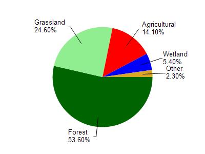
Rush Creek is located in the Otter and Morrey Creeks watershed which is 198.69 mi². Land use in the watershed is primarily forest (53.60%), grassland (24.60%) and a mix of agricultural (14.10%) and other uses (7.70%). This watershed has 437.57 stream miles, 351.55 lake acres and 5,785.74 wetland acres.
Nonpoint Source Characteristics
This watershed is ranked Not Ranked for runoff impacts on streams, Low for runoff impacts on lakes and High for runoff impacts on groundwater and therefore has an overall rank of High. This value can be used in ranking the watershed or individual waterbodies for grant funding under state and county programs.However, all waters are affected by diffuse pollutant sources regardless of initial water quality. Applications for specific runoff projects under state or county grant programs may be pursued. For more information, go to surface water program grants.