Richland, Sauk
No
No
Yes
Fish and Aquatic Life
Overview
Little Bear Creek is a seepage and spring fed tributary to Bear Creek. The majority of the surrounding sub-watershed has been cleared at one time for agricultural purposes. The stream supports cold water forage fish. Streambank pasturing and close proximity to feedlots and barnyards is a threat to the creek.
From: Ripp, Coreen, Koperski, Cindy and Folstad, Jason. 2002. The State of the Lower Wisconsin River Basin. PUBL WT-559-2002. Wisconsin Department of Natural Resources, Madison, WI
Date 2002
Author Cynthia Koperski
Historical Description
Little Bear Creek was monitored extensively from 2007-2009, and the segment from the mouth upstream to mile 6.77 has been proposed to be added to the impaired waters list in 2010. The pollutants responsible for this proposed listing are phosphorus, sediment and water temperature, and the impairments are degraded habitat and eutrophication.
Date 2011
Author Jean Unmuth
Historical Description
Little Bear Creek is a spring fed 8.0 mile long tributary of Bear Creek. In 2007 and 2008, three different stream stations were monitored by the WDNR. Fish, aquatic insects, water quality, and stream habitat information was collected. Results indicated the stream’s condition was poor to very poor, except for the uppermost reach near the headwaters which was rated
good.
During the summer of 2007, stream temperatures were continuously monitored at all three segments. In July and August, 11% of 17 mean daily
samples collected exceeded 73 degrees F (22.7 C), above the acceptable temperature of 65 degrees F (18.3 degrees C), the optimal temperature for growth of brown trout. Phosphorus samples, collected over a 6 month period in 2008 by the United States Geological Survey (USGS), exceeded 0.075 mg/l (75 ug/l) in 5 of 6 samples.
This level is at the upper threshold for phosphorus water quality criteria currently listed under the rule revision being proposed for small streams. The proposed criteria are intended to prevent in-stream algae and other plant growth to the extent that it is detrimental to fi sh and aquatic life.
Stream channelization and ditched wetlands have increased siltation in the lower stream reaches where low stream gradient allows silt to settle out, rather than fl ush through the system. The stream has good permanent flow from large springs in the upper stream segment. Much of the riparian stream corridor is either cropped or pastured. There are several dairy operations along the stream, causing pasturing in some wetland areas along the stream corridor. One of the larger dairy operations along the stream had a manure pit overfl ow into wetlands adjacent to the stream, but that operation was abandoned in late 2009. Non-point source pollution from agricultural sources has likely increased phosphorus, reduced water clarity in some stream segments, and increased water temperature.
Bank and stream habitat information was collected at three stations along the stream. Results indicated that fish habitat was rated fair in the ditched segment, where the stream is wide and shallow with few natural meanders. While there are some stream segments that are deep enough to support cold water game fi sh, sand and sediment overlays much of the gravel and cobble so that it reduces the available fi sh spawning habitat. The stream appears to have a lack of rock riffl es used for fi sh spawning and fi sh food or aquatic insect production. It also lacks the deeper pools necessary for fish resting and over-wintering. In the lower stream reaches, where the channel appears not to have been ditched, there are natural meanders and deeper pools, but banks are steep and in some areas eroded. In addition, some wetlands have been drained by ditching, which also increases transportation of sediment and nutrients like nitrogen and phosphorus from agricultural lands.
Date 2011
Author Jean Unmuth
Impaired Waters
Little Bear Creek (1234700), from its mouth to an unnamed tributary WBIC 5033157, was placed on the impaired waters list for total phosphorus and sediment/total suspended solids in 2010. The 2016 assessments showed continued impairment by phosphorus; total phosphorus sample data exceed 2016 WisCALM listing criteria for the Fish and Aquatic Life use and biological impairment was observed (i.e. at least one macroinvertebrate or fish Index of Biotic Integrity (IBI) scored in the poor condition category). This water was also assessed for temperature and sample data did not exceed 2016 WisCALM listing criteria for the Fish and Aquatic Life use. Based on the most updated information, no change in existing impaired waters listing is needed.
Date 2015
Author Aaron Larson
Impaired Waters
Stream was historically ditched and moved out of the original bed (channelized), starting approximately 2 miles downstream from the headwaters, for approximately ½ of its stream length or about 4 miles total channelized. Agricultural use, mainly crops in upper ½ along the stream is heavy, with very little to no vegetative buffers. Grazing may not contribute greatly to impairment, but large concentrated animal feeding operations exist close to the stream, and one specifically has been problematic due to an overflow of manure storage tank to a wetland area bordering the stream. Little Bear Creek was listed in 2010 based on narrative criteria, and reassessed in 2012 and updated based on numeric TP criteria.
Date 2011
Author Aquatic Biologist
Condition
Wisconsin has over 84,000 miles of streams, 15,000 lakes and milllions of acres of wetlands. Assessing the condition of this vast amount of water is challenging. The state's water monitoring program uses a media-based, cross-program approach to analyze water condition. An updated monitoring strategy (2015-2020) is now available. Compliance with Clean Water Act fishable, swimmable standards are located in the Executive Summary of Water Condition in 2018. See also the 'monitoring and projects' tab.
Reports
Recommendations
Monitor or Propose 303(d) Listing
Collect additional data 303 d evaluation and to determine if the stream has the potential to reach the attainable use listing of Cold water. Little Bear Creek is located in Sauk and Richland Counties.
Monitor Targeted Area
Monitor temperature to assess impacts of ponds in the headwaters of Little Bear Creek.
Restore Hydrology, Morphology
Encourage projects that restore stream meandering of Little Bear Creek.
Restore Wetlands
Reduce reed canary infestations in wet meadows and forested wetlands using wetland restoration best management practices.
Habitat Restoration - Instream
Cooperate with Aldo Leopold and Ocooch Chapters of Trout Unlimited, Richland and Sauk County LCD and NRCS and other partners to improve fish and stream bank habitat in Bear and Little Bear Creeks and other tributaries through TRM, Stream Protection and TMDL Implementation grants.
Monitor Targeted Area
A stream condition assessment should be conducted on Little Bear Creek to determine if any management actions could help improve the instream habitat.
Aquatic Plant Monitoring or Survey
Two Strategies, one for IR data rollout , the other for Watershed Planning Meetings in the spring.
Management Goals
Wisconsin's Water Quality Standards provide qualitative and quantitative goals for waters that are protective of Fishable, Swimmable conditions [Learn more]. Waters that do not meet water quality standards are considered impaired and restoration actions are planned and carried out until the water is once again fishable and swimmable
Management goals can include creation or implementation of a Total Maximum Daily Load analysis, a Nine Key Element Plan, or other restoration work, education and outreach and more. If specific recommendations exist for this water, they will be displayed below online.
Monitoring
Monitoring the condition of a river, stream, or lake includes gathering physical, chemical, biological, and habitat data. Comprehensive studies often gather all these parameters in great detail, while lighter assessment events will involve sampling physical, chemical and biological data such as macroinvertebrates. Aquatic macroinvertebrates and fish communities integrate watershed or catchment condition, providing great insight into overall ecosystem health. Chemical and habitat parameters tell researchers more about human induced problems including contaminated runoff, point source dischargers, or habitat issues that foster or limit the potential of aquatic communities to thrive in a given area. Wisconsin's Water Monitoring Strategy was recenty updated.
Grants and Management Projects
Monitoring Projects
| WBIC | Official Waterbody Name | Station ID | Station Name | Earliest Fieldwork Date | Latest Fieldwork Date | View Station | View Data |
|---|
| 1234700 | Little Bear Creek | 10052568 | Little Bear Creek 18ft US Farm Road | 6/5/2019 | 10/26/2021 | Map | Data |
| 1234700 | Little Bear Creek | 10021057 | Little Bear Creek At Cth. B Fire #E3298 Ishmael | 6/22/2007 | 1/1/2015 | Map | Data |
| 1234700 | Little Bear Creek | 10048647 | Little Bear Creek 350ft DS CTH B | 6/5/2017 | 10/26/2021 | Map | Data |
| 1234700 | Little Bear Creek | 10021319 | Little Bear Creek-2nd Bridge near 33311 Cth B | 8/17/2007 | 11/13/2023 | Map | Data |
|
Watershed Characteristics
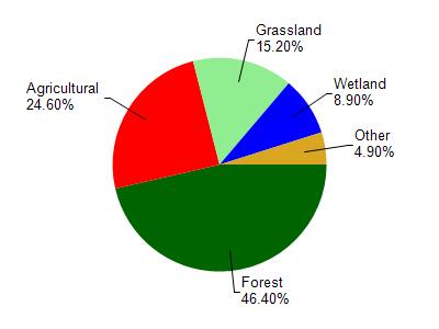
Little Bear Creek is located in the Bear Creek watershed which is 136.54 mi². Land use in the watershed is primarily forest (46.40%), agricultural (24.60%) and a mix of grassland (15.20%) and other uses (13.80%). This watershed has 236.07 stream miles, 119.46 lake acres and 6,798.61 wetland acres.
Nonpoint Source Characteristics
This watershed is ranked Medium for runoff impacts on streams, Not Ranked for runoff impacts on lakes and High for runoff impacts on groundwater and therefore has an overall rank of High. This value can be used in ranking the watershed or individual waterbodies for grant funding under state and county programs.This water is ranked High Stream for individual Rivers based on runoff problems and the likelihood of success from project implementation.