Rock
Yes
Yes
Yes
Fish and Aquatic Life
Overview
This 26-mile stream begins in southern Dane County, flows southeast through Rock County and turns west flowing into Green County where it enters into the Sugar River. The creek’s entire watershed is developed for agriculture which contributes a sizable influx of sediment into the stream, much of which settles out at Lake Leota (WDNR, 1980a). A dam with an eight foot head forms the lake and prevents fish movement upstream. Water warmed from the impoundment also has a thermal impact downstream from the dam. Dam removal would enhance the cold water attributes of Allen Creek (Bush, 2001) The municipalities of Brooklyn and Evansville discharge to the creek.
The first 11 miles from the mouth up to Old 92 Road is a diverse warm water fishery and classified as an Exceptional Resource Water (ERW). The next 10 miles of stream, with the exception of Lake Leota, are classified cold trout waters. A section from Old 92 Road up to the dam at Lake Leota is also ERW. The section from the dam at Lake Leota downstream to Hwy 213 has been upgraded from a Class III trout water to a Class II water. A potential point of contention occurs at CTH T. While the stream is classified as a Class III trout stream downstream of CTH T, upstream from this point it is classified as a limited forage fishery. The discharge from the Brooklyn WWTP enters the stream immediately upstream from the highway, leaving a potential disparity between the basis for the discharge limits and the trout stream classification immediately downstream. Allen Creek was last evaluated in 1996 for game species. Both stocked and carryover trout as well as several year classes of smallmouth bass were found in this survey.
Date 2002
Author Aquatic Biologist
Overview
This 26-mile stream begins in southern Dane County, flows southeast through Rock County and turns west flowing into Green County where it enters into the Sugar River. The creek’s entire watershed is developed for agriculture which contributes a sizable influx of sediment into the stream, much of which settles out at Lake Leota (Surface Waters of Green Co). A dam with an eight foot head forms the lake and prevents fish movement upstream. Water warmed from the impoundment also has a thermal impact downstream from the dam. Dam removal would enhance the cold water attributes of Allen Creek (Bush, pers. comm.) The municipalities of Brooklyn and Evansville discharge to the creek.
The first 11 miles from the mouth up to Old 92 Road is a diverse warm water fishery and classified as an Exceptional Resource Water (ERW). The next 10 miles of stream, with the exception of Lake Leota, are classified cold trout waters. A section from Old 92 Road up to the dam at Lake Leota is also ERW. The section from the dam at Lake Leota downstream to Hwy 213 has been upgraded from a Class III trout water to a Class II water. A potential point of contention occurs at CTH T. While the stream is classified as a Class III trout stream downstream of CTH T, upstream from this point it is classified as a limited forage fishery. The discharge from the Brooklyn WWTP enters the stream immediately upstream from the highway, leaving a potential disparity between the basis for the discharge limits and the trout stream classification immediately downstream. Allen Creek was last evaluated in 1996 for game species. Both stocked and carryover trout as well as several year classes of smallmouth bass were found in this survey.
Date 1996
Author Aquatic Biologist
Historical Description
From: Lake and Stream Classification Project. Surface Water Resources of Green County, Wisconsin Department of Natural Resources, 1980.
Although it originates and ends in Green County, most of Allen Creek lies in western Rock County". Its origin is a rather diffuse area of wide ditches which drain farmland northwest of Brooklyn. The entire watershed is
developed for agriculture which contributes a sizeable influx of silt to the strearl1, much of which settles out at Lake Leota. Treated sewage effluent from both Brooklyn and Evansville present possible sources of pollu-
tion. A dam with an eight foot head forms the 41 acre Lake Leota at Evansville (Rock County). An inland lake
renewal project is attempting to improve the lake by improving the incoming water quality. To impede siltation and prevent additional bank erosion, stretches of the stream have been fenced and lined with stone riprapping.
Proposals are also under consideration to deepen the lake through the removal of silt deposits.
After reentering Green County, Allen Creek meanders through shallow banks which are stabilized with good grass cove~, in spite of heavy grazing. The streambed is rather broad and composed of gravel and sand scoured by
the strong current. Undercut banks, scour holes and sand or gravel bars are common. The flows of Liberty and Dunphy Creeks merge with Allen Creek before it joins the Sugar River just above Albany Millpond. Instream vegetation is found only in the headwaters.
In Green County, Allen Creek is classified as a smallmouth bass-catfish stream and supports abundant and diverse forage fish. Twenty-eight different species of fish are found in the stream including the rare least darter. In Rock County above Lake Leota, 3.9 miles are classified as trout water and an occasional brown
trout is caught in Green County. W1ldlife values are good. r~uskrats are present and 130 acres of adjoining wetlands provide habitat for numerous game species. Public access is provided at five road crossings in Green County.
Fish Species: Brown trout, central mudminnow, stoneroller unspecified, carp, common shiner, spotfin shiner, sand shiner, suckermouth minnow, southern redbelly dace, bluntnose minnow, fathead minnow, creek chub, white sucker, northern hog sucker, black bullhead, yellow bullhead, channel catfish, stonecat, brook stickleback, green sunfish, bluegill, smallmouth bass, rainbow darter, fantail darter, least darter, Johnny darter, banded darter, blackside darter.
Surface Acres = 27.0, Length = 7.5 Miles, Gradient = 5 ft./mi., Base Discharge = 49.0 cu. ft./sec,
Date 1980
Author Surface Water Inventory Of Wisconsin
Historical Description
Allen Creek flows west-southwest into the Sugar River approximately 2 miles north of Albany. Managed primarily for smallmouth bass and forage fish Channel Catfish are present near the outlet. Most of the stream bottm is silt deposited from the runoff of the area's farmland. An estimated 377 acres of wetlands adjoin the stream and provide refuge fora significant muskrat population. Very little stream bank cover. From: Poff, Ronald J., and C.W. Threinen, Lake and Stream Classification Project. Surface Water Resources of Green County, Wisconsin Conservation Department, Madison I, 1961.
Date 1961
Author Surface Water Inventory Of Wisconsin
Impaired Waters
Allen Creek was recently evaluated during the ten-year period of 2009 through 2018 for results that were reported to the USEPA for the 2020 Clean Water Act condition report. The waterbody is considered impaired, or in poor condition for designated uses which include the quality of fish and aquatic life, recreational use, and public health and welfare (fish consumption and related). Pollutants or problems encountered during sampling (impairments) are determined based on water quality standards outlined in Wisconsin 2020 Consolidated Assessment and Listing Methodology (WisCALM). Assessment results show water conditions that are potentially harmful for Aquatic Life use due to values for total phosphorus and biological indicators that fall into the range expected for an aquatic community in poor health, therefore this water is listed as impaired.
Allen Creek [Mouth to Old HWY 92 (mile 0-10.57)]: Assessment results during the 2018 listing cycle show impairment due to levels of Total Phosphorus, however available Index of Biotic Integrity (IBI) data did not indicate impairment. Based on the updated information, this segment was proposed for the impaired waters list in 2018.
Allen Creek [Old HWY 92 to HWY 213 (mile 10.57-12.61)]: Assessment results during the 2020 listing cycle show total phosphorus levels too high for healthy aquatic communities like plants, fish and bugs, according to 2020 WisCALM standards. Available temperature and biological data do not indicate impairment (i.e. no fish Index of Biotic Integrity (IBI) scored in the "poor" condition category). Based on the most updated information, this water was proposed for the impaired waters list in 2020.
Allen Creek [HWY 213 to Lake Leota dam (mile 12.6-14.99)]: This segment is in good condition for Aquatic Life and Fish Consumption uses.
Allen Creek [Lake Leota inlet to Brooklyn-Evansville Rd. (mile 15-20.21)]: Assessment results during the 2020 listing cycle show total phosphorus levels too high for healthy aquatic communities like plants, fish, and bugs, according to 2020 WisCALM standards. Fish and bug sample data were also in poor condition (i.e. at least one macroinvertebrate and fish Index of Biotic Integrity scored in the poor condition category). Based on the most updated information, total phosphorus was added to the previous listing of degraded biological habitat.
Allen Creek [Brooklyn-Evansville Rd. to CTH T (mile 20.22-22.96)]: This segment has been listed as impaired since 2016 for total phosphorus.
Allen Creek [CTH T to headwaters (mile 22.96-26.98)]: This segment has been listed as impaired since 2016 for total phosphorus.
Date 2019
Author Ashley Beranek
Impaired Waters
The 2018 assessments of Allen Creek (mouth to Old HWY 92) showed impairment by phosphorus; new total phosphorus sample data exceeded the 2018 WisCALM listing criteria for the Fish and Aquatic Life use. However, available biological data did not indicate impairment (i.e. no macroinvertebrate or fish Index of Biotic Integrity (IBI) scored in the "poor" condition category). Based on the most updated information, this water was proposed for the impaired waters list.
Date 2017
Author Ashley Beranek
Impaired Waters
Allen Creek (883700) from Evansville Road to headwaters was assessed during the 2016 listing cycle; total phosphorus sample data exceed 2016 WisCALM listing criteria for the Fish and Aquatic Life use and biological impairment was observed (i.e. at least one macroinvertebrate or fish Index of Biotic Integrity (IBI) scored in the poor condition category). Allen Creek from Lake Leota inlet to Brooklyn-Evansville Rd was assessed during the 2016 listing cycle; biological impairment was observed (i.e. at least one macroinvertebrate or fish Index of Biotic Integrity (IBI) average scored in the poor condition category).
Date 2015
Author Aaron Larson
Condition
Wisconsin has over 84,000 miles of streams, 15,000 lakes and milllions of acres of wetlands. Assessing the condition of this vast amount of water is challenging. The state's water monitoring program uses a media-based, cross-program approach to analyze water condition. An updated monitoring strategy (2015-2020) is now available. Compliance with Clean Water Act fishable, swimmable standards are located in the Executive Summary of Water Condition in 2018. See also the 'monitoring and projects' tab.
Reports
Recommendations
Citizen-Based Stream Monitoring
Collect chemical, physical, and/or biological water quality data to assess the current overall stream health. The data can inform management decisions and may be used to identify impaired waters for biennial lists.
Citizen-Based Stream Monitoring
Collect chemical, physical, and/or biological water quality data to assess the current overall stream health. The data can inform management decisions and may be used to identify impaired waters for biennial lists.
Citizen-Based Stream Monitoring
Collect chemical, physical, and/or biological water quality data to assess the current overall stream health. The data can inform management decisions and may be used to identify impaired waters for biennial lists.
Monitor Water Quality or Sediment
2014 TP: "May Meet". AU: 5542005. Station 10020531. Miles 22.96 - 26.98 (headwaters). Potential for TP delisting in 2020.
Monitor Water Quality or Sediment
Category 5A. 2018 TP Results: May Meet. Station: 10020531. AU: 5542005.
Management Goals
Wisconsin's Water Quality Standards provide qualitative and quantitative goals for waters that are protective of Fishable, Swimmable conditions [Learn more]. Waters that do not meet water quality standards are considered impaired and restoration actions are planned and carried out until the water is once again fishable and swimmable
Management goals can include creation or implementation of a Total Maximum Daily Load analysis, a Nine Key Element Plan, or other restoration work, education and outreach and more. If specific recommendations exist for this water, they will be displayed below online.
Monitoring
Monitoring the condition of a river, stream, or lake includes gathering physical, chemical, biological, and habitat data. Comprehensive studies often gather all these parameters in great detail, while lighter assessment events will involve sampling physical, chemical and biological data such as macroinvertebrates. Aquatic macroinvertebrates and fish communities integrate watershed or catchment condition, providing great insight into overall ecosystem health. Chemical and habitat parameters tell researchers more about human induced problems including contaminated runoff, point source dischargers, or habitat issues that foster or limit the potential of aquatic communities to thrive in a given area. Wisconsin's Water Monitoring Strategy was recenty updated.
Grants and Management Projects
Monitoring Projects
| WBIC | Official Waterbody Name | Station ID | Station Name | Earliest Fieldwork Date | Latest Fieldwork Date | View Station | View Data |
|---|
| 883700 | Allen Creek | 10010702 | Allen Creek Upsteam Of Old 92 | 1/1/2015 | 10/9/2017 | Map | Data |
| 883700 | Allen Creek | 10013328 | Allen Creek Hwy 213 | 11/14/2023 | 11/14/2023 | Map | Data |
| 883700 | Allen Creek | 10013329 | Allen Creek Old Hwy 92 Bridge | | | Map | Data |
| 883700 | Allen Creek | 10013327 | Allen Creek Mid-Way Old 92-213 | | | Map | Data |
| 883700 | Allen Creek | 10010690 | Allen Creek upstream Hwy 213 | 11/6/2003 | 8/17/2024 | Map | Data |
|
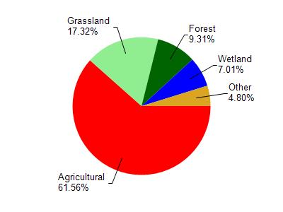
Watershed Characteristics
Allen Creek is located in the Allen Creek and Middle Sugar River watershed which is 154.01 mi². Land use in the watershed is primarily agricultural (61.50%), grassland (17.30%) and a mix of forest (9.30%) and other uses (11.80%). This watershed has 263.25 stream miles, 96.10 lake acres and 5,963.23 wetland acres.
Nonpoint Source Characteristics
This watershed is ranked Medium for runoff impacts on streams, Not Ranked for runoff impacts on lakes and High for runoff impacts on groundwater and therefore has an overall rank of High. This value can be used in ranking the watershed or individual waterbodies for grant funding under state and county programs.However, all waters are affected by diffuse pollutant sources regardless of initial water quality. Applications for specific runoff projects under state or county grant programs may be pursued. For more information, go to surface water program grants.