Bayfield
Yes
Yes
No
Fish and Aquatic Life
Overview
This high quality trout water arises from springs near the Chequamegon National Forest and flows some 17 miles to empty into Lake Superior in the Sioux River Slough north of Washburn. The entire river is an outstanding resource water and several high quality trout streams are tributary to it. The river is a Class II trout fishery for roughly half of its length, and a Class I fishery from County Highway C west. Runs of rainbow and brown trout and coho salmon occur and brook and brown trout are resident in the stream. Past water quality evaluations indicated clear and cool waters upstream, with downstream areas carrying a light load of suspended clay particles. The river and its wetlands provide excellent habitat for nesting and migratory waterfowl and furbearers. One interesting feature of this river is Big Rock Hole, where a deep hole has been delved below a wide flat layer of bedrock. During low flow, this steep layer of bedrock above Big Rock Hole can be a temporary obstacle to migratory trout. Bayfield County maintains a wayside park with camping facilities at Big Rock. WDNR has, through permanent easements, set up public fishing grounds along about three-quarters of a mile of the Sioux River. The Sioux River falls within the South Shore Fish and Wildlife Area. The mouth and estuary are in state ownership, while the river flows through a combination of state and privately held lands. The watershed supports agriculture and forestry among its activities.
The Sioux River enters Lake Superior through extensive wetlands. The area also has a beach and sandstone cliffs that support unique plants. The wetland estuary complex also features a shoreline bog. The estuary connects with that of the Onion River to the north. The Lake Superior Binational Program identified this area as important to the integrity of the Lake Superior ecosystem for coastal wetlands, rare communities, vital functions for planning objectives and fish and wildlife spawning and nursery grounds.
The exotic purple loosestrife, an escaped garden perennial, has been a problem in the sloughs at the mouth of the river. Loosestrife can alter the natural wetland water flow and vegetation that wildlife rely on. WDNR Fisheries Management applied a pesticide that was fairly successful. Due to staff and funding shortages, additional WDNR work is not anticipated, but the project may be turned over to The Nature Conservancy (Swanson).
The Sioux River was identified by the Lake Superior Coastal Wetland Evaluation (Epstein 1997) as an aquatic priority site. The fauna was diverse, with 35 taxa present, four of which are rare. Caddisflies, mayflies and beetles were dominants. Management concerns noted included turbidity, low flow, filamentous algae and silt.
From: Turville-Heitz, Meg. 1999. Lake Superior Basin Water Quality Management Plan. Wisconsin Department of Natural Resources, Madison, WI.
Date 1999
Author Aquatic Biologist
Condition
Wisconsin has over 84,000 miles of streams, 15,000 lakes and milllions of acres of wetlands. Assessing the condition of this vast amount of water is challenging. The state's water monitoring program uses a media-based, cross-program approach to analyze water condition. An updated monitoring strategy (2015-2020) is now available. Compliance with Clean Water Act fishable, swimmable standards are located in the Executive Summary of Water Condition in 2018. See also the 'monitoring and projects' tab.
Reports
Recommendations
Information and Education
The Inland Sea Society proposes to conduct an organizational development and informational & educational project in the Sioux River watershed in Bayfield County. Activities involved with this project will include; organization of a watershed council, compilation of landowner database, compilation of a geographical database, conduct of public informational meetings with the distribution of newsletters, fact sheets, and informational maps, establishment of a monitoring system, training of citizen volunteer monitors, and the development of a strategic action plan for the direction of the watershed council. Reports of ongoing project activities would be disseminated via newsletter(s) or brochures(s), meeting(s), and the preparation of a final report.
Management Goals
Wisconsin's Water Quality Standards provide qualitative and quantitative goals for waters that are protective of Fishable, Swimmable conditions [Learn more]. Waters that do not meet water quality standards are considered impaired and restoration actions are planned and carried out until the water is once again fishable and swimmable
Management goals can include creation or implementation of a Total Maximum Daily Load analysis, a Nine Key Element Plan, or other restoration work, education and outreach and more. If specific recommendations exist for this water, they will be displayed below online.
Monitoring
Monitoring the condition of a river, stream, or lake includes gathering physical, chemical, biological, and habitat data. Comprehensive studies often gather all these parameters in great detail, while lighter assessment events will involve sampling physical, chemical and biological data such as macroinvertebrates. Aquatic macroinvertebrates and fish communities integrate watershed or catchment condition, providing great insight into overall ecosystem health. Chemical and habitat parameters tell researchers more about human induced problems including contaminated runoff, point source dischargers, or habitat issues that foster or limit the potential of aquatic communities to thrive in a given area. Wisconsin's Water Monitoring Strategy was recenty updated.
Grants and Management Projects
Monitoring Projects
| WBIC | Official Waterbody Name | Station ID | Station Name | Earliest Fieldwork Date | Latest Fieldwork Date | View Station | View Data |
|---|
| 2886000 | Sioux River | 10034878 | Sioux River above 4mile Creek | 1/1/2015 | 1/1/2015 | Map | Data |
| 2886000 | Sioux River | 10022591 | Sioux River - Upstream From Mouth Of Little Sioux River At Friendly Valley Rd | | | Map | Data |
| 2886000 | Sioux River | 043069 | Sioux River - Above Sth 13 Site 2 | | | Map | Data |
| 2886000 | Sioux River | 10034877 | Sioux River above Big Rock Rd | 1/1/2015 | 1/1/2015 | Map | Data |
| 2886000 | Sioux River | 10042903 | Sioux River at Friendly Valley Rd | 9/13/2014 | 7/13/2023 | Map | Data |
| 2886000 | Sioux River | 043068 | Sioux River - Above Mouth Site 1 | 10/17/2007 | 9/30/2011 | Map | Data |
| 2886000 | Sioux River | 10040606 | Sioux River 500ft N of CTH C | 10/6/2007 | 5/26/2010 | Map | Data |
| 2886000 | Sioux River | 10030309 | Sioux River - Upstream of CTH C | 8/26/2009 | 9/14/2021 | Map | Data |
| 2886000 | Sioux River | 043020 | Sioux River at Sth 13 | 5/24/2016 | 8/29/2017 | Map | Data |
| 2886000 | Sioux River | 10037126 | Sioux River below confluence of Little Souix | 5/24/2012 | 1/1/2015 | Map | Data |
| 2886000 | Sioux River | 10035246 | Sioux River - Area of Open Water | 9/26/2010 | 9/26/2010 | Map | Data |
| 2886000 | Sioux River | 10031831 | Sioux River - off Friendly Valley Rd | 10/13/2010 | 1/1/2015 | Map | Data |
| 2886000 | Sioux River | 10042902 | Sioux River at Big Rock Rd | 4/10/2014 | 7/23/2018 | Map | Data |
|
Watershed Characteristics
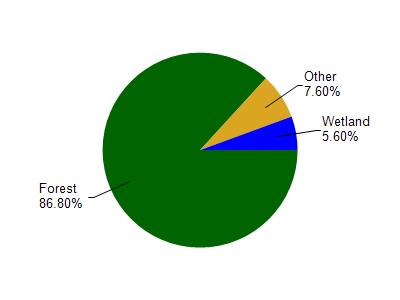
Sioux River is located in the Bayfield Peninsula Southeast watershed which is 301.48 mi². Land use in the watershed is primarily forest (86.80%), wetland (5.60%) and a mix of grassland (4.10%) and other uses (3.50%). This watershed has 453.79 stream miles, 291,749.17 lake acres and 6,560.31 wetland acres.
Nonpoint Source Characteristics
This watershed is ranked Not Ranked for runoff impacts on streams, Not Available for runoff impacts on lakes and Low for runoff impacts on groundwater and therefore has an overall rank of Low. This value can be used in ranking the watershed or individual waterbodies for grant funding under state and county programs.However, all waters are affected by diffuse pollutant sources regardless of initial water quality. Applications for specific runoff projects under state or county grant programs may be pursued. For more information, go to surface water program grants.