Langlade
Yes
Yes
No
Fish and Aquatic Life
Overview
Spring Brook, a 19 mile long stream, flows southwesterly through Antigo before joining the Eau Claire River in northeast Marathon County. The stream is intermittent in the headwaters and spring-fed in the Antigo Flats area. There are no perennial feeder streams associated with Spring Brook.
Spring Brook is classified as a Class I trout stream for 17 of its 19 miles. The segment of stream not considered Class I trout stream lacks quality habitat, experiences warmer water temperatures, and exhibits poor dissolved oxygen conditions. This stretch of stream is classified as a warm water sport and forage fishery. Spring Brook is not reaching its highest potential use due to pollution form nonpoint sources. Eroding croplands and improperly managed livestock operation are the major sources of nonpoint pollution in the watershed.
Date 2002
Author Aquatic Biologist
General Condition
Spring Brook is not reaching its highest potential use due to pollution form nonpoint sources. Eroding croplands and improperly managed livestock operation are the major sources of nonpoint pollution in the watershed. Two 10 Year Median Macroinvertebrate IBI Values on the impaired waters stretch are fair on the downstream strech and poor on the upper portions of the impaired waters stretch.
Date 2011
Author Aquatic Biologist
Condition
Wisconsin has over 84,000 miles of streams, 15,000 lakes and milllions of acres of wetlands. Assessing the condition of this vast amount of water is challenging. The state's water monitoring program uses a media-based, cross-program approach to analyze water condition. An updated monitoring strategy (2015-2020) is now available. Compliance with Clean Water Act fishable, swimmable standards are located in the Executive Summary of Water Condition in 2018. See also the 'monitoring and projects' tab.
Reports
Recommendations
Monitor Aquatic Biology
AU 18345, poor mIBI, Station 343062
Nine Key Element Plan
Spring Brook PWS Plan - Nine Key Element Plan - The Spring Brook Priority Watershed Project plan assesses the nonpoint sources of pollution in the Spring Brook Watershed and guides the implementation of nonpoint source control measures. These control measures are needed to meet specific water resource objectives for Spring Brook and its tributaries. The purpose of this project is to reduce the amount of pollutants originating from nonpoint sources that reach surface water and groundwater within the Spring Brook Priority Watershed Project area. It is a 67 square mile watershed located in Langlade and Marathon Counties.
Runoff Grant
Spring Brook Watershed should remain a high priority for future grant eligibility under the State Nonpoint Source
Pollution Abatement Program.
Fish Management, Access
DNR Fisheries Management should look into developing some type of restricted harvest regulation so the quality
and trophy brook trout fishing is maintained on Spring Brook.
Restore Wetlands
DNR Staff should determine the cause of excessive plant growth (Reed Canary Grass) below Antigo and evaluate
control options and conduct dissolved oxygen studies.
Restore Riparian Habitat
DNR Staff should continue to pursue land acquisition or leases along Spring Brook for streambank protection and
habitat improvement.
Stormwater Planning, Implementation
Encourage the use of rain gardens and rain barrels in the City of Antigo.
Information and Education
Inform the public of habitat loss and the impacts of those losses upon fish and wildlife populations, water quality, flood control and the quality of life.
Protect Riparian or Shorelands
Educate the public concerning shoreline preservation and restoration.
Biomonitoring Toxicity Tests
Stream sediment and water should be collected for bioassessment toxicity testing above and below the old coal gas
plant.
Monitor Baseline Survey
Sediment monitoring should be conducted in Spring Brook, and tested for Polycyclic Aromatic Hydrocarbons, Volatile Organic Compounds and metals.
Monitor to Evaluate Projects
DNR Water Resources and R & R Programs should continue to monitor water quality during the clean-up phase of contaminated soils associated with the old coal gasification plant adjacent to Spring Brook.
Information and Education
Educate the public on the installation and use of rain gardens and rain barrels.
Management Goals
Wisconsin's Water Quality Standards provide qualitative and quantitative goals for waters that are protective of Fishable, Swimmable conditions [Learn more]. Waters that do not meet water quality standards are considered impaired and restoration actions are planned and carried out until the water is once again fishable and swimmable
Management goals can include creation or implementation of a Total Maximum Daily Load analysis, a Nine Key Element Plan, or other restoration work, education and outreach and more. If specific recommendations exist for this water, they will be displayed below online.
Monitoring
Monitoring the condition of a river, stream, or lake includes gathering physical, chemical, biological, and habitat data. Comprehensive studies often gather all these parameters in great detail, while lighter assessment events will involve sampling physical, chemical and biological data such as macroinvertebrates. Aquatic macroinvertebrates and fish communities integrate watershed or catchment condition, providing great insight into overall ecosystem health. Chemical and habitat parameters tell researchers more about human induced problems including contaminated runoff, point source dischargers, or habitat issues that foster or limit the potential of aquatic communities to thrive in a given area. Wisconsin's Water Monitoring Strategy was recenty updated.
Grants and Management Projects
Monitoring Projects
| WBIC | Official Waterbody Name | Station ID | Station Name | Earliest Fieldwork Date | Latest Fieldwork Date | View Station | View Data |
|---|
| 1440800 | Spring Brook | 343129 | Spring Brook - 350 Ft Ab Hwy 64 | | | Map | Data |
| 1440800 | Spring Brook | 10003158 | Spring Brook - 15 Abv Cth X | | | Map | Data |
| 1440800 | Spring Brook | 10054701 | Spring Brook | 9/16/2020 | 10/22/2021 | Map | Data |
| 1440800 | Spring Brook | 10054702 | Spring Brook | 9/16/2020 | 6/1/2022 | Map | Data |
| 1440800 | Spring Brook | 343062 | Spring Brook at Sth 64 | 3/15/1984 | 1/1/2015 | Map | Data |
| 1440800 | Spring Brook | 10056130 | SPRING BROOK CREEK DS CHERRY RD (OLD STATION 18) | | | Map | Data |
| 1440800 | Spring Brook | 10056131 | SPRING BROOK CREEK (OLD STATION 19) | | | Map | Data |
| 1440800 | Spring Brook | 343111 | Spring Brook - Highway 64 /Upstream Of Bridge North Side Of Stream | 5/24/1984 | 6/1/2022 | Map | Data |
|
Watershed Characteristics
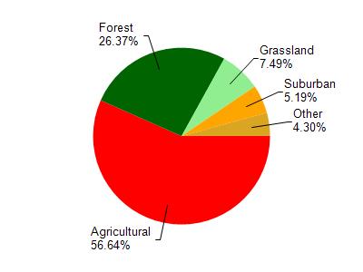
Spring Brook is located in the Springbrook Creek watershed which is 69.77 mi². Land use in the watershed is primarily agricultural (56.70%), forest (26.40%) and a mix of grassland (7.50%) and other uses (9.50%). This watershed has 99.73 stream miles, 65.96 lake acres and 977.95 wetland acres.
Nonpoint Source Characteristics
This watershed is ranked High for runoff impacts on streams, Medium for runoff impacts on lakes and High for runoff impacts on groundwater and therefore has an overall rank of High. This value can be used in ranking the watershed or individual waterbodies for grant funding under state and county programs.However, all waters are affected by diffuse pollutant sources regardless of initial water quality. Applications for specific runoff projects under state or county grant programs may be pursued. For more information, go to surface water program grants.