Price
No
Yes
No
Fish and Aquatic Life
Overview
SOUTH FORK FLAMBEAU RIVER - The South Fork Flambeau River originates at the outlet of Round Lake in eastern Price
County. Round Lake's watershed includes western Vilas and Oneida counties and runsthrough the Chequamegon National Forest. Several low-head dams form impoundmentsused largely for recreation on tributaries in the South Fork watershed.
The South Fork joins the North Fork in the Flambeau River State Forest in southeastern Sawyer County. Wastewater discharge from the Flambeau State Prison Camp flows to the South Fork via Hackett Creek and a wetland. The entire South Fork of the Flambeau River is designated as an outstanding resource water under state antidegradation.
Larson, Nancy and Lisa Kosmond (Helmuth). 1996. Upper Chippewa River Basin Water Quality Management Plan.
PUBL-WR-345-96-REV. Wisconsin Department of Natural Resources, Madison, WI.
Date 1996
Author Aquatic Biologist
Overview
The lower South Fork of the Flambeau River supports a warm water sports fishery and
is stocked with muskellunge and bass. We have no recent water quality information on
this stretch of the River. This segment of the Flambeau is very diverse in terms of
endangered resources. It contains the best known population of the extra-striped
snaketail dragonfly (Wisconsin Endangered) in the Midwest. It is a Bureau of
Endangered Resources priority to achieve a protected corridor from the Chequamegon
National Forest down to the Flambeau State Forest. It would be beneficial to aquatic
species to have a forested river corridor connecting two large public forests across the
area of largely private ownership. Protection of water quality and habitat is very
important in this river segment.
Date 1996
Author Aquatic Biologist
Condition
Wisconsin has over 84,000 miles of streams, 15,000 lakes and milllions of acres of wetlands. Assessing the condition of this vast amount of water is challenging. The state's water monitoring program uses a media-based, cross-program approach to analyze water condition. An updated monitoring strategy (2015-2020) is now available. Compliance with Clean Water Act fishable, swimmable standards are located in the Executive Summary of Water Condition in 2018. See also the 'monitoring and projects' tab.
Reports
Recommendations
Citizen-Based Stream Monitoring
Collect chemical, physical, and/or biological water quality data to assess the current overall stream health. The data can inform management decisions and may be used to identify impaired waters for biennial lists.
Citizen-Based Stream Monitoring
Collect chemical, physical, and/or biological water quality data to assess the current overall stream health. The data can inform management decisions and may be used to identify impaired waters for biennial lists.
Citizen-Based Stream Monitoring
Collect chemical, physical, and/or biological water quality data to assess the current overall stream health. The data can inform management decisions and may be used to identify impaired waters for biennial lists.
Watershed Mapping or Assessment
The South Fork Flambeau River Watershed Association under sponsorship by the Price County Waterways Assoc., will build organizational capacity, document baseline river data and educate river users. Activities associated with this project include the creation of an association to advocate for the S. Fork Flambeau River to work cooperatively with other groups and agencies with similar purposes including the development of a plan for partnership development and the integration of the assoc. resources with other managing organziations; establish a water quality testing program to collect baseline data; conduct a riparian landowner assessment to compile information on demographics, perceptions, opinions, & concerns, and assess interest in an educational river fair; collection and compilation of baseline environmental, historical and recreational data including a GIS/Video survey of the river for invasives, buffer conditions, zoning violations, erosion concerns, and habitat conditions/restoration opportunities. River stewardship and environmental awareness will be promoted through education and outreach including the development of an information distribution system, certified buffer awards program, newsletter and media releases and other events. A final report of all activities will be developed and submitted to the Department in both paper and electronic format.
Management Goals
Wisconsin's Water Quality Standards provide qualitative and quantitative goals for waters that are protective of Fishable, Swimmable conditions [Learn more]. Waters that do not meet water quality standards are considered impaired and restoration actions are planned and carried out until the water is once again fishable and swimmable
Management goals can include creation or implementation of a Total Maximum Daily Load analysis, a Nine Key Element Plan, or other restoration work, education and outreach and more. If specific recommendations exist for this water, they will be displayed below online.
Monitoring
Monitoring the condition of a river, stream, or lake includes gathering physical, chemical, biological, and habitat data. Comprehensive studies often gather all these parameters in great detail, while lighter assessment events will involve sampling physical, chemical and biological data such as macroinvertebrates. Aquatic macroinvertebrates and fish communities integrate watershed or catchment condition, providing great insight into overall ecosystem health. Chemical and habitat parameters tell researchers more about human induced problems including contaminated runoff, point source dischargers, or habitat issues that foster or limit the potential of aquatic communities to thrive in a given area. Wisconsin's Water Monitoring Strategy was recenty updated.
Grants and Management Projects
Monitoring Projects
| WBIC | Official Waterbody Name | Station ID | Station Name | Earliest Fieldwork Date | Latest Fieldwork Date | View Station | View Data |
|---|
| 2231200 | South Fork Flambeau River | 513031 | South Fork Flambeau River STH 70 Fifield | 2/21/1975 | 9/13/2006 | Map | Data |
| 2231200 | South Fork Flambeau River | 10019845 | South Fork Flambeau River -- Access Off Sugar Bush Ln | 10/17/2006 | 10/17/2006 | Map | Data |
| 2231200 | South Fork Flambeau River | 10042604 | South Fork Flambeau River-Logging Dam | 1/1/2015 | 1/1/2015 | Map | Data |
| 2231200 | South Fork Flambeau River | 10029422 | S Fork Flambeau R about 1.25 miles US of landing at East Road | | | Map | Data |
| 2231200 | South Fork Flambeau River | 513168 | Flambeau River South Fork - Fr 152 Bridge | 10/5/2004 | 1/1/2015 | Map | Data |
| 2231200 | South Fork Flambeau River | 10012531 | Flambeau River South Fork - Cedar Rapids At Bridge | 6/11/2006 | 1/1/2015 | Map | Data |
| 2231200 | South Fork Flambeau River | 10020325 | South Fork Flambeau River -- Access at Smith Rapids Rd | 8/26/2013 | 8/26/2013 | Map | Data |
| 2231200 | South Fork Flambeau River | 10035474 | South Fork Flambeau River - Area of Open Water | | | Map | Data |
| 2231200 | South Fork Flambeau River | 10019776 | South Fork Flambeau River -- Canoe Launch | | | Map | Data |
| 2231200 | South Fork Flambeau River | 513167 | South Fork Flambeau River - Shady Knoll Bridge | 5/4/1994 | 1/1/2015 | Map | Data |
| 2231200 | South Fork Flambeau River | 10022249 | South Fork Flambeau River At Woody Road | 1/1/2015 | 1/1/2015 | Map | Data |
| 2231200 | South Fork Flambeau River | 10022282 | South Fork Flambeau River At Krucky Road | | | Map | Data |
| 2231200 | South Fork Flambeau River | 10020259 | South Fork Flambeau River -- Carry In Access E of Shady Knoll Rd | 10/5/2004 | 10/5/2004 | Map | Data |
| 2231200 | South Fork Flambeau River | 10020249 | South Fork Flambeau River -- Carry-In at Balsam St | | | Map | Data |
| 2231200 | South Fork Flambeau River | 10035156 | South Fork Flambeau River - Area of Open Water | | | Map | Data |
| 2231200 | South Fork Flambeau River | 10038047 | Round Lake (Price Co) - Off Logging Dam Rd | 6/6/2011 | 6/6/2011 | Map | Data |
| 2231200 | South Fork Flambeau River | 10019847 | South Fork Flambeau River -- Access at East Rd | 9/13/2006 | 9/13/2006 | Map | Data |
| 2231200 | South Fork Flambeau River | 10034215 | South Fork Flambeau River 20m US Divine Rapids Rd. | 8/16/2011 | 1/1/2015 | Map | Data |
| 2231200 | South Fork Flambeau River | 513032 | Flambeau River South Fork - Sth 13 Fifield | 2/21/1975 | 11/5/1975 | Map | Data |
| 2231200 | South Fork Flambeau River | 10049378 | South Fork Flambeau River- Along Lofdahl Road | | | Map | Data |
| 2231200 | South Fork Flambeau River | 10019846 | South Fork Flambeau River -- Carry-In along Sugarbush Rd | 8/26/2013 | 8/26/2013 | Map | Data |
| 2231200 | South Fork Flambeau River | 10047000 | South Fork Flambeau River - Sturgeon Hole - 0.8mi DS East Rd. Landing | | | Map | Data |
| 2231200 | South Fork Flambeau River | 10049407 | South Fork Flambeau River--Round Lake Dam to State Hwy 13 | | | Map | Data |
| 2231200 | South Fork Flambeau River | 513215 | Flambeau River South Fork - Smith Rpds | | | Map | Data |
| 2231200 | South Fork Flambeau River | 10036836 | South Fork Flambeau River - Area of Open Water | | | Map | Data |
| 2231200 | South Fork Flambeau River | 10050930 | South Fork Flambeau River upstream of HWY 13 | 6/19/2019 | 9/17/2024 | Map | Data |
|
Watershed Characteristics
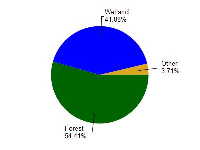
South Fork Flambeau River is located in the Lower South Fork Flambeau River watershed which is 200.15 mi². Land use in the watershed is primarily forest (54.30%), wetland (41.80%) and a mix of grassland (1.70%) and other uses (2.00%). This watershed has 187.09 stream miles, 607.14 lake acres and 42,848.94 wetland acres.
Nonpoint Source Characteristics
This watershed is ranked Not Ranked for runoff impacts on streams, Low for runoff impacts on lakes and Low for runoff impacts on groundwater and therefore has an overall rank of Low. This value can be used in ranking the watershed or individual waterbodies for grant funding under state and county programs.However, all waters are affected by diffuse pollutant sources regardless of initial water quality. Applications for specific runoff projects under state or county grant programs may be pursued. For more information, go to surface water program grants.