Manitowoc
No
No
Yes
Fish and Aquatic Life
Overview
Bullhead Lake is a 67-acre landlocked seepage lake lying in an outwash plain, with hard, alkaline water
and a maximum depth of 40 feet. The mean depth is 13 feet. There are 1.07 miles of shoreline of which
0.01 miles are publicly owned. Twelve acres of wooded wetlands adjoin the lake. The watershed
encompasses 2.0 square miles. Hybrid Muskellunge were stocked in 1980, but it is unlikely any remain.
Walleye have been stocked throughout the 1980s. Largemouth and smallmouth bass are common, and
panfish are abundant. This lake is listed under a consumption advisory because of mercury levels.
DNR staff treated the lake with aluminate on August 23, 1978. As part of a research project, aluminum
sulfite was applied through the process of hypolimnetic injection. (See WDNR Tech. Bulletin #153). The treatment worked for almost 10 years before phosphorus levels reached pretreatment levels.
In 1986, the Bullhead Lake Association requested guidance from the WDNR due to high levels of
phosphorus causing increased algal productivity. WDNR provided technical assistance for a second
aluminum sulfite treatment applied on October 8, 1988, at four to six feet below the water surface in an area of the lake with depths greater than 12 feet. The treatment proved successful, although phosphorous levels as of 1991 are increasing.
Bullhead Lake is monitored by volunteers as part of self-help monitoring program. Secchi disc readings
have been taken since 1986. Since 1990, Bullhead Lake has been part of the expanded self-help
monitoring program. Dissolved oxygen, pH, phosphorus, and secchi data are now available from this
expanded volunteer data collection program. Bullhead Lake received a High ranking using the NPS criteria developed for lakes and is therefore eligible as a Priority Lake Project under the NPS program. Using the phosphorus classification scheme, Bullhead Lake falls into Class 1A (phosphorus sensitive). The water quality of the lake is threatened as recent data shows phosphorus values increasing just three years after the aluminum sulfite treatment. Cropping practices in the drainage area are degrading the water quality.
The implementation of best management practices in the lake's watershed would protect the investment the lake district made through the application of aluminum sulfite and protect this high use lake and its aesthetic value. The Bureau of Integrated Science Services (SS), in conjunction with the Northeast Region Lake Biologist, collected a sediment core from Bullhead Lake during the summer of 1991. The core was to be used to better characterize the trophic history of Bullhead Lake. This information can then be used to establish achievable water quality goals and better realize the potential for a full recovery of the lake. This technique has proven useful for the management and understanding of other lake systems in Wisconsin. The status for this core data is unknown. The lake association applied in August 1995 and received a lake planning grant to characterize land use practices that impact water quality in Bullhead Lake. The district limnologist is working with the lake association to determine impacts of sediment delivery to the lake following significant rain events. Please refer to the district Watershed Management files for specific data on the lake study.
Date 2002
Author Aquatic Biologist
Historical Description
Source: 1968, Surface Water Resources of Manitowoc County Bullhead Lake, T19N, R21E, Section 19 Surface acres - 67, S.D.F. = 1.07, Maximum depth = 35 feet.
A landlocked seepage lake lying in an outwash plain. The clear water is hard and alkaline. The bottom is largely gravel and muck. The lake was chemically treated in 1957 to rectify a stunted panfish problem. Subsequent stocking of muskellunge now provides one of the few fisheries of this type in east central Wisconsin. Largemouth bass, bluegills and perch also contribute to the fishery. There is a county park with 260 feet of frontage and parking. Water skiing and the use of live bait for fishing are prohibited. There are 12 acres of adjoining wetland. Hunting is permitted and moderate numbers of both puddle and diving ducks provide some shooting.
Date 1968
Author Surface Water Inventory Of Wisconsin
Impaired Waters
Bullhead Lake (WBIC 68300) was placed on the impaired waters list for Mercury in 1998 and total phosphorus in 2012. The 2018 assessments showed continued impairment by phosphorus; new total phosphorus sample data exceeded the 2018 WisCALM listing thresholds for the Recreation use and Fish and Aquatic Life use. Chlorophyll-a sample data clearly exceeded the REC use thresholds, but clearly met the FAL use threshold. Based on the most updated information, no change in existing impaired waters listing was needed.
Date 2017
Author Ashley Beranek
Impaired Waters
Bullhead Lake (68300) was placed on the impaired waters list for Mercury in 1998 and total phosphorus in 2012. The 2016 assessments showed continued impairment by phosphorus; total phosphorus and chlorophyll sample data exceeded 2016 WisCALM listing thresholds for the Recreation use, but did not exceed Fish and Aquatic Life thresholds. Based on the most updated information, no change in existing impaired waters listing is needed.
Date 2015
Author Aaron Larson
Condition
Wisconsin has over 84,000 miles of streams, 15,000 lakes and milllions of acres of wetlands. Assessing the condition of this vast amount of water is challenging. The state's water monitoring program uses a media-based, cross-program approach to analyze water condition. An updated monitoring strategy (2015-2020) is now available. Compliance with Clean Water Act fishable, swimmable standards are located in the Executive Summary of Water Condition in 2018. See also the 'monitoring and projects' tab.
Reports
Recommendations
Monitor Paleocore
One sediment core was taken in Bullhead Lake in 1991. Diatom analysis was done, final report submitted 2008.
Monitor Fish Tissue
Management Goals
Wisconsin's Water Quality Standards provide qualitative and quantitative goals for waters that are protective of Fishable, Swimmable conditions [Learn more]. Waters that do not meet water quality standards are considered impaired and restoration actions are planned and carried out until the water is once again fishable and swimmable
Management goals can include creation or implementation of a Total Maximum Daily Load analysis, a Nine Key Element Plan, or other restoration work, education and outreach and more. If specific recommendations exist for this water, they will be displayed below online.
Monitoring
Monitoring the condition of a river, stream, or lake includes gathering physical, chemical, biological, and habitat data. Comprehensive studies often gather all these parameters in great detail, while lighter assessment events will involve sampling physical, chemical and biological data such as macroinvertebrates. Aquatic macroinvertebrates and fish communities integrate watershed or catchment condition, providing great insight into overall ecosystem health. Chemical and habitat parameters tell researchers more about human induced problems including contaminated runoff, point source dischargers, or habitat issues that foster or limit the potential of aquatic communities to thrive in a given area. Wisconsin's Water Monitoring Strategy was recenty updated.
Grants and Management Projects
Monitoring Projects
| WBIC | Official Waterbody Name | Station ID | Station Name | Earliest Fieldwork Date | Latest Fieldwork Date | View Station | View Data |
|---|
| 68300 | Bullhead Lake | 10019449 | Bull Head Lake -- Access at End Of Bullhead Lake Ln | 3/6/2009 | 7/11/2025 | Map | Data |
| 68300 | Bullhead Lake | 10003513 | Bullhead Lake | 11/23/1989 | 8/10/2023 | Map | Data |
| 68300 | Bullhead Lake | 363064 | Bullhead Lake - Deep Hole | 6/25/1986 | 10/31/2025 | Map | Data |
|
Watershed Characteristics
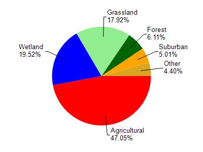
Bullhead Lake is located in the Lower Manitowoc River watershed which is 168.33 mi². Land use in the watershed is primarily agricultural (47%), wetland (19.50%) and a mix of grassland (17.90%) and other uses (15.50%). This watershed has 264.70 stream miles, 2,910.36 lake acres and 19,995.06 wetland acres.
Nonpoint Source Characteristics
This watershed is ranked High for runoff impacts on streams, Not Ranked for runoff impacts on lakes and High for runoff impacts on groundwater and therefore has an overall rank of High. This value can be used in ranking the watershed or individual waterbodies for grant funding under state and county programs.However, all waters are affected by diffuse pollutant sources regardless of initial water quality. Applications for specific runoff projects under state or county grant programs may be pursued. For more information, go to surface water program grants.