Calumet
No
No
Yes
Fish and Aquatic Life
Overview
This water's extent runs from Danes Road to the headwaters (LFF).
Date 2010
Author Aquatic Biologist
Overview
Pine Creek is a well-buffered healthy stream in Calumet County that receives no noticeable nonpoint
source pollution and has no point source discharges along its length. Due to its cool temperature and
adequate year 'round flow, Fisheries staff believe it could support trout. Biotic index work indicates “very
good” water quality.
Jordan Creek is a tributary of Pine Creek. Information collected during the May 1990 triennial standards
review for Pine and Jordan Creek indicates a higher quality resource in Pine Creek and a higher potential
in Jordan Creek than existing classifications suggest.
The Water Resources Division of the U.S. Geological Survey, in cooperation with local, State and Federal
agencies, obtains a large amount of data pertaining to the water resources of Wisconsin each year
(Holmstrom 1995). Two surface water quality stations are located on Pine Creek; Meggers Road near
New Holstein (monitored April to September 1995) and at Quarry Road near Hayton (monitored February
1994 to September 1995). The water samples have been collected at the two stations and analyzed for
PCB's, chlorophyll A, chloride, particle size and suspended sediments. Please refer to the U.S. Geological
Survey Water Resource Data Wisconsin Water Year 1995 for specific data.
From: Willman, Guy and Mike Toneys. 2001. The State of the Lakeshore Basin. Wisconsin Department of Natural Resources, Madison, WI.
Date 2001
Author Michael Toneys
Overview
Hayton Millpond is located in Calmet County near the Village of New Holstein. In the early 1990s, the WDNR found PCBs in Hayton Millpond and more than six miles upstream between the Village of New Holstein and the Millpond. The Killsnake Wildlife Area is immediately downstream of the millpond. Presently the WDNR and Tecumseh Products Company, working on a voluntary basis, have developed a remediation plan for the "source area" just north of the village. The PCB concentrations in the source area range from less than one mg/kg to 2,500 mg/kg.
As a first phase of this plan scheduled for 2000, all sediment with PCB concentrations of more than 50 mg/kg will be removed. The sediments will be properly disposed at a cost of about $700,000, with partial funding from the U.S. EPA Great Lakes National Program Office. Removal of additional PCB contaminated sediments in the source area is anticipated for 2001. Remediation plans for the downstream areas will likely be completed in 2001 or 2002. Issues that need to be resolved for the downstream areas include whether to remove sediment in major deposition areas along Pine Creek or construct a new channel to replace about four miles of natural stream channel. Another difficult issue is when and whether to remove the dam at Hayton.
Date 2000
Author Aquatic Biologist
Impaired Waters
Pine Creek was recently evaluated during the ten-year period of 2009 through 2018 for results that were reported to the USEPA for the 2020 Clean Water Act condition report. The waterbody is considered impaired, or in poor condition for designated uses which include the quality of fish and aquatic life, recreational use, and public health and welfare (fish consumption and related). Pollutants or problems encountered during sampling (impairments) are determined based on water quality standards outlined in Wisconsin 2020 Consolidated Assessment and Listing Methodology (WisCALM). Assessment results show water conditions that are potentially harmful for Aquatic Life use due to values for total phosphorus that fall into the range expected for an aquatic community in poor health, therefore this water is listed as impaired.
Pine Creek (mile 0-5.54): Assessment results during the 2020 listing cycle show new impairment by overwhelmingly high total phosphorus levels inappropriate for a healthy waterbody. This segment was previously listed for PCBs in 1998. Based on the updated information, total phosphorus is a proposed addition during the 2020 listing cycle.
Pine Creek (mile 5.54-9.12): Assessment results during the 2020 listing cycle show continued impairment by total phosphorus. Phosphorus levels were overwhelmingly high for a healthy water body; however, chloride, biological indicators, and temperature levels were appropriate for a healthy waterbody. This segment has been listed as impaired for PCBs since 1998 and for total phosphorus since 2016 and no change is needed.
Date 2019
Author Ashley Beranek
Impaired Waters
Pine Creek (this segment Danes Road to headwaters, WBIC 79900) was assessed during the 2016 listing cycle; total phosphorus sample data exceed 2016 WisCALM listing criteria for the Fish and Aquatic Life use and biological impairment was observed (i.e. at least one macroinvertebrate or fish Index of Biotic Integrity (IBI) scored in the poor condition category).
Date 2015
Author Aaron Larson
Condition
Wisconsin has over 84,000 miles of streams, 15,000 lakes and milllions of acres of wetlands. Assessing the condition of this vast amount of water is challenging. The state's water monitoring program uses a media-based, cross-program approach to analyze water condition. An updated monitoring strategy (2015-2020) is now available. Compliance with Clean Water Act fishable, swimmable standards are located in the Executive Summary of Water Condition in 2018. See also the 'monitoring and projects' tab.
Reports
Management Goals
Wisconsin's Water Quality Standards provide qualitative and quantitative goals for waters that are protective of Fishable, Swimmable conditions [Learn more]. Waters that do not meet water quality standards are considered impaired and restoration actions are planned and carried out until the water is once again fishable and swimmable
Management goals can include creation or implementation of a Total Maximum Daily Load analysis, a Nine Key Element Plan, or other restoration work, education and outreach and more. If specific recommendations exist for this water, they will be displayed below online.
Monitoring
Monitoring the condition of a river, stream, or lake includes gathering physical, chemical, biological, and habitat data. Comprehensive studies often gather all these parameters in great detail, while lighter assessment events will involve sampling physical, chemical and biological data such as macroinvertebrates. Aquatic macroinvertebrates and fish communities integrate watershed or catchment condition, providing great insight into overall ecosystem health. Chemical and habitat parameters tell researchers more about human induced problems including contaminated runoff, point source dischargers, or habitat issues that foster or limit the potential of aquatic communities to thrive in a given area. Wisconsin's Water Monitoring Strategy was recenty updated.
Grants and Management Projects
| Project Name (Click for Details) | Year Started |
|---|
|
|
Monitoring Projects
| WBIC | Official Waterbody Name | Station ID | Station Name | Earliest Fieldwork Date | Latest Fieldwork Date | View Station | View Data |
|---|
| 79900 | Pine Creek | 10038086 | PINE CREEK - 300 FEET UPSTREAM OF SOUTH 151 | 4/27/1992 | 4/27/1992 | Map | Data |
| 79900 | Pine Creek | 10038096 | PINE CREEK - BY THE STUMP | 11/12/1992 | 11/12/1992 | Map | Data |
| 79900 | Pine Creek | 083116 | Pine Creek - Honeymoon Rd Near New Holstein WI | 6/16/1993 | 10/11/2023 | Map | Data |
| 79900 | Pine Creek | 083085 | Pine Creek - 275 Feet Upstream Of Hayton Road | 8/31/1993 | 8/31/1993 | Map | Data |
| 79900 | Pine Creek | 10038015 | HAYTON MILLPOND PINE CREEK - 7025 FEET UPSTREAM OF HAYTON RD | 8/31/1993 | 8/31/1993 | Map | Data |
| 79900 | Pine Creek | 10038182 | HAYTON MILLPOND PINE CREEK - 300 FT US DAM | 9/1/1993 | 9/1/1993 | Map | Data |
| 79900 | Pine Creek | 083062 | Pine Creek at Quarry Rd Bridge | 2/16/1994 | 10/11/2023 | Map | Data |
| 79900 | Pine Creek | 10038085 | PINE CREEK - 500 FEET UPSTREAM OF SOUTH 151 | 11/12/1992 | 11/12/1992 | Map | Data |
| 79900 | Pine Creek | 10007556 | Pine Creek - Pine Creek Upstream Cth T | 7/26/2010 | 7/26/2010 | Map | Data |
| 79900 | Pine Creek | 10038010 | Hayton Millpond Pine Cr - 3425 Ft US of Hayton Rd | 8/31/1993 | 8/31/1993 | Map | Data |
| 79900 | Pine Creek | 10038013 | HAYTON MILLPOND PINE CREEK - 5225 FEET UPSTREAM OF HAYTON RD | 8/31/1993 | 8/31/1993 | Map | Data |
| 79900 | Pine Creek | 10037985 | Pine Creek - 1625 Feet US Hayton Road | 8/31/1993 | 8/31/1993 | Map | Data |
| 79900 | Pine Creek | 10037980 | Pine Creek - 75 Feet US Hayton Rd | 8/31/1993 | 8/18/2023 | Map | Data |
| 79900 | Pine Creek | 10038012 | HAYTON MILLPOND PINE CREEK - 4625 FEET UPSTREAM OF HAYTON RD | 8/31/1993 | 8/31/1993 | Map | Data |
| 79900 | Pine Creek | 083086 | Pine Creek - 425 Feet Upstream Of Hayton Road | 8/31/1993 | 8/31/1993 | Map | Data |
| 79900 | Pine Creek | 10012556 | Pine Creek At Danes Rd. | 8/22/2006 | 1/1/2015 | Map | Data |
| 79900 | Pine Creek | 083068 | Pine Creek - 1625 Ft Upstream Of Hayton Rd Quarry Rd | | | Map | Data |
| 79900 | Pine Creek | 10038090 | PINE CREEK - AT THE BEND | 11/12/1992 | 11/12/1992 | Map | Data |
| 79900 | Pine Creek | 10038020 | HAYTON MILLPOND PINE CREEK - 150 FEET DOWNSTREAM OF DANES RD | 9/1/1993 | 9/1/1993 | Map | Data |
| 79900 | Pine Creek | 10038089 | PINE CREEK - BEFORE NEXT BEND | 11/12/1992 | 11/12/1992 | Map | Data |
| 79900 | Pine Creek | 10038092 | Pine Creek - Between Bend and Farm Bridge | 11/12/1992 | 11/12/1992 | Map | Data |
| 79900 | Pine Creek | 10037988 | Pine Creek - 2225 Feet DS Hayton Road | 8/31/1993 | 8/31/1993 | Map | Data |
| 79900 | Pine Creek | 10037981 | Pine Creek - 1025 Feet US Hayton Road | 8/31/1993 | 8/31/1993 | Map | Data |
| 79900 | Pine Creek | 10038007 | HAYTON MILLPOND PINE CREEK - 2825 FEET UPSTREAM OF HAYTON RD | 8/31/1993 | 8/31/1993 | Map | Data |
| 79900 | Pine Creek | 10038014 | HAYTON MILLPOND PINE CREEK - 6125 FEET UPSTREAM OF HAYTON RD | 8/31/1993 | 8/31/1993 | Map | Data |
| 79900 | Pine Creek | 10038022 | HAYTON MILLPOND PINE CREEK - 600 FEET UPSTREAM OF HONEYMOON HILL RD | 9/1/1993 | 9/1/1993 | Map | Data |
| 79900 | Pine Creek | 10015682 | Pine Creek - Danes Road Crossing | 8/15/2006 | 8/15/2006 | Map | Data |
| 79900 | Pine Creek | 10038091 | PINE CREEK - BEFORE POWER LINES | 11/12/1992 | 11/12/1992 | Map | Data |
| 79900 | Pine Creek | 10038087 | PINE CREEK - AT FIRST BEND | 11/12/1992 | 11/12/1992 | Map | Data |
| 79900 | Pine Creek | 10038016 | HAYTON MILLPOND PINE CREEK - 7775 FEET UPSTREAM OF HAYTON RD | 8/31/1993 | 8/31/1993 | Map | Data |
| 79900 | Pine Creek | 10038023 | Hayton Millpond Pine Creek -1200 US of Honeymoon Hill Rd | 9/1/1993 | 9/1/1993 | Map | Data |
| 79900 | Pine Creek | 10038088 | PINE CREEK - AROUND THE BEND | 11/12/1992 | 11/12/1992 | Map | Data |
| 79900 | Pine Creek | 10038011 | HAYTON MILLPOND PINE CREEK - 4025 FEET UPSTREAM OF HAYTON RD | 8/31/1993 | 8/31/1993 | Map | Data |
| 79900 | Pine Creek | 10038024 | HAYTON MILLPOND PINE CREEK - 2100 UPSTREAM OF HONEYMOON HILL RD | 9/1/1993 | 9/1/1993 | Map | Data |
|
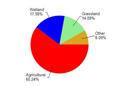
Watershed Characteristics
Pine Creek is located in the South Branch Manitowoc River watershed which is 189.10 mi². Land use in the watershed is primarily agricultural (60.30%), wetland (17.60%) and a mix of grassland (14.10%) and other uses (8.10%). This watershed has 228.03 stream miles, 86.31 lake acres and 21,287.68 wetland acres.
Nonpoint Source Characteristics
This watershed is ranked High for runoff impacts on streams, High for runoff impacts on lakes and High for runoff impacts on groundwater and therefore has an overall rank of High. This value can be used in ranking the watershed or individual waterbodies for grant funding under state and county programs.However, all waters are affected by diffuse pollutant sources regardless of initial water quality. Applications for specific runoff projects under state or county grant programs may be pursued. For more information, go to surface water program grants.