Milwaukee
No
No
Yes
Fish and Aquatic Life
Overview
Honey Creek originates at the S. 43rd Street storm sewer outfall in the City of Greenfield and flows in a northerly direction for approximately 8.8 miles until its confluence with the Menomonee River in the City of Wauwatosa. The Honey Creek subwatershed encompasses 11 square miles and includes portions of the communities of Greenfield, Milwaukee, Wauwatosa, and West Allis. Channel modifications such as deepening, straightening, and lining with concrete have been made to 7.1 miles of Honey Creek. The Creek flows under State Fair Park in an enclosed channel that consists of 3 - 10' X 15' pipes. The Honey Creek subwatershed has experienced minor flooding problems, but the biggest problem with this Creek has been the ecological degradation and habitat loss due to channel modifications.
Honey Creek was added to the MMSD sampling program in 2003 and includes five sampling sites (HC-01 - HC-05). Baseline data will be collected for several years prior to any stream improvement projects. Sampling will continue during construction and for several years after construction is completed in order to document potential water quality improvement.
Date 2016
Author Mmsd
Impaired Waters
Honey Creek was put on the impaired waters list for bacteria in 2010, phosphorus and degraded biology in 2012, and aquatic toxicity due to chloride in 2018. Evaluations in cycles 2020 and 2022 confirmed the phosphorus and chloride listings.
Date 2022
Author Ashley Beranek
Condition
Wisconsin has over 84,000 miles of streams, 15,000 lakes and milllions of acres of wetlands. Assessing the condition of this vast amount of water is challenging. The state's water monitoring program uses a media-based, cross-program approach to analyze water condition. An updated monitoring strategy (2015-2020) is now available. Compliance with Clean Water Act fishable, swimmable standards are located in the Executive Summary of Water Condition in 2018. See also the 'monitoring and projects' tab.
Reports
Recommendations
Habitat Restoration - Instream
Opportunities exist to restore some of the traditional in-stream and riparian habitat that existed in the watershed before urbanization, while providing more stormwater buffer zone in this densely urbanized area.
Citizen-Based Stream Monitoring
Collect chemical, physical, and/or biological water quality data to assess the current overall stream health. The data can inform management decisions and may be used to identify impaired waters for biennial lists.
Management Goals
Wisconsin's Water Quality Standards provide qualitative and quantitative goals for waters that are protective of Fishable, Swimmable conditions [Learn more]. Waters that do not meet water quality standards are considered impaired and restoration actions are planned and carried out until the water is once again fishable and swimmable
Management goals can include creation or implementation of a Total Maximum Daily Load analysis, a Nine Key Element Plan, or other restoration work, education and outreach and more. If specific recommendations exist for this water, they will be displayed below online.
Monitoring
Monitoring the condition of a river, stream, or lake includes gathering physical, chemical, biological, and habitat data. Comprehensive studies often gather all these parameters in great detail, while lighter assessment events will involve sampling physical, chemical and biological data such as macroinvertebrates. Aquatic macroinvertebrates and fish communities integrate watershed or catchment condition, providing great insight into overall ecosystem health. Chemical and habitat parameters tell researchers more about human induced problems including contaminated runoff, point source dischargers, or habitat issues that foster or limit the potential of aquatic communities to thrive in a given area. Wisconsin's Water Monitoring Strategy was recenty updated.
Grants and Management Projects
Monitoring Projects
| WBIC | Official Waterbody Name | Station ID | Station Name | Earliest Fieldwork Date | Latest Fieldwork Date | View Station | View Data |
|---|
| 16300 | Honey Creek | 10047936 | Honey Creek at 84th Street and W O'Connor Street | 1/1/2015 | 1/1/2015 | Map | Data |
| 16300 | Honey Creek | 10010558 | Honey Creek 16 - at bridge N of Aurora Hospice | 6/26/2006 | 11/26/2014 | Map | Data |
| 16300 | Honey Creek | 10053104 | Honey Creek US N 84th Street | 3/20/2019 | 11/6/2023 | Map | Data |
| 16300 | Honey Creek | 10047950 | Honey Creek at S Honey Creek Drive near Armour Park | 1/1/2015 | 1/1/2015 | Map | Data |
| 16300 | Honey Creek | 10010561 | Honey Creek - 2- (Northwest Of Honey Creek Pky) | 5/1/1997 | 9/25/2014 | Map | Data |
| 16300 | Honey Creek | 10010562 | Honey Creek - 101 | | | Map | Data |
| 16300 | Honey Creek | 10030407 | Honey Creek at Honey Creek Pkwy | 5/24/2012 | 2/22/2021 | Map | Data |
| 16300 | Honey Creek | 10030241 | Honey Creek at CTH Y (W Layler Rd) | 6/1/2009 | 10/5/2021 | Map | Data |
| 16300 | Honey Creek | 10047953 | Honey Creek DS W Loomis Road | 1/1/2015 | 10/5/2021 | Map | Data |
| 16300 | Honey Creek | 413676 | Honey Creek - Near Portland Ave At Wauwatosa WI | 5/18/1979 | 8/21/2019 | Map | Data |
| 16300 | Honey Creek | 413006 | Honey Creek - Near Confluence With Menominee River | 1/13/1975 | 5/16/1997 | Map | Data |
| 16300 | Honey Creek | 413638 | Honey Creek - Verona Ct-Storm Sewer Honey Crk | | | Map | Data |
| 16300 | Honey Creek | 10037400 | Honey Creek DS of Honey Creek Pkwy S of HWY 18 | 8/29/2012 | 1/1/2015 | Map | Data |
| 16300 | Honey Creek | 10047938 | Honey Creek DS W Wisconsin Avenue | 1/1/2015 | 11/6/2023 | Map | Data |
| 16000 | Menomonee River | 413298 | Torngren/Spincraft Corp. *** Permit Re | | | Map | Data |
| 16300 | Honey Creek | 10040002 | Honey Cr at 70th and Honey Cr Pkwy | 11/8/2001 | 10/25/2004 | Map | Data |
| 16300 | Honey Creek | 10047934 | Honey Creek US W Arthur Avenue | 1/1/2015 | 11/6/2023 | Map | Data |
|
Projects
Opportunities exist to restore some of the traditional in-stream and riparian habitat that existed in the watershed before urbanization, while providing more stormwater buffer zone in this densely urbanized area.
The Milwaukee Estuary Remedial Action Plan (1995) prepared by the WDNR, lists as a goal the development of high quality aquatic and wildlife habitats. One of the objectives described in the plan was to evaluate and implement recommendations regarding removal or modification of human-made obstructions along the rivers which restrict navigation and natural fish movement (connectivity), spawning, feeding, protection, development or winter habitat. Northern pike and walleye are the top fish predators targeted by the WDNR for significant population increases as game fish in response to connectivity to spawning habitat in the Menomonee River and river tributaries.
Date 2016
Author Army Corps Of Engineers
Watershed Characteristics
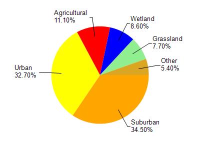
Honey Creek is located in the Menomonee River watershed which is 136.12 mi². Land use in the watershed is primarily suburban (34.50%), urban (32.70%) and a mix of agricultural (11.10%) and other uses (21.70%). This watershed has 174.17 stream miles, 352.64 lake acres and 5,967.40 wetland acres.
Nonpoint Source Characteristics
This watershed is ranked High for runoff impacts on streams, High for runoff impacts on lakes and High for runoff impacts on groundwater and therefore has an overall rank of High. This value can be used in ranking the watershed or individual waterbodies for grant funding under state and county programs.However, all waters are affected by diffuse pollutant sources regardless of initial water quality. Applications for specific runoff projects under state or county grant programs may be pursued. For more information, go to surface water program grants.