")
3.57 Miles
8.41 - 11.98
Warm Headwater, COOL-Warm Headwater
2025
Poor
Degraded Biological Community, Degraded Habitat
Total Phosphorus, Sediment/Total Suspended Solids
Outagamie, Waupaca
No
No
Yes
Fish and Aquatic Life
Overview
Bear Creek is a nine-mile-long tributary to the Embarrass River. Flanagan Brothers Inc., a sauerkraut processing plant, has a lagoon next to the stream for the discharge of cooling and wash water. There have been problems with an unpermitted discharge from the lagoons overflowing into Bear Creek.
There is adequate flow, good habitat, and the biotic index shows fair water quality in Bear Creek (Doelger, 1995). The stream is used for spring spawning of northern pike and supports panfish most times of the year.
From: Bougie, Cheryl A., Kosmond, Lisa D, and Watermolen, Dreux J. 1996. Wolf River Basin Water Quality Management Plan. Wisconsin Department of Natural Resources, Madison, WI.
Date 1996
Author Cheryl Bougie
Impaired Waters
Bear Creek was recently evaluated during the ten-year period of 2009 through 2018 for results that were reported to the USEPA for the 2020 Clean Water Act condition report. The waterbody is considered impaired, or in poor condition for designated uses which include the quality of fish and aquatic life, recreational use, and public health and welfare (fish consumption and related). Pollutants or problems encountered during sampling (impairments) are determined based on water quality standards outlined in Wisconsin 2020 Consolidated Assessment and Listing Methodology (WisCALM). Assessment results show water conditions that are potentially harmful for Aquatic Life use due to values for total phosphorus that fall into the range expected for an aquatic community in poor health, therefore this water is listed as impaired.
Bear Creek (mile 0-8.41): Assessment results during the 2020 listing cycle show total phosphorus levels too high for healthy aquatic communities, like plants, fish, and bugs, according to 2020 WisCALM standards. Based on the most updated information, this water was proposed for the impaired waters list in 2020.
Bear Creek (8.41-11.98): This portion of the creek has been listed as impaired since 2002 for total suspended solids and since 2016 for total phosphorus.
Bear Creek (11.98-18.42): This portion of the creek is in good condition for Fish Consumption use, however there is not enough information to assess Aquatic Life use.
Date 2019
Author Ashley Beranek
Impaired Waters
This segment of Bear Creek (292100) from Hwy 45 to just past the town of Bear Creek was assessed during the 2016 listing cycle; total phosphorus sample data exceed 2016 WisCALM listing criteria for the Fish and Aquatic Life use and biological impairment was observed (i.e. at least one macroinvertebrate or fish Index of Biotic Integrity (IBI) scored in the poor condition category).
Date 2015
Author Aaron Larson
Condition
Wisconsin has over 84,000 miles of streams, 15,000 lakes and milllions of acres of wetlands. Assessing the condition of this vast amount of water is challenging. The state's water monitoring program uses a media-based, cross-program approach to analyze water condition. An updated monitoring strategy (2015-2020) is now available. Compliance with Clean Water Act fishable, swimmable standards are located in the Executive Summary of Water Condition in 2018. See also the 'monitoring and projects' tab.
Reports
Recommendations
Restore Riparian Habitat
The Aldo Leopold Chapter of Trout Unlimited will participate in River Management grant program by implementing a stream restoration plan on Bear Creek. Project deliverables include: 1.) Implementing stream-restoration plans for two miles of stream length (it is likely that the Wadeable Stream Qualitative Fish Habitat Rating will be significantly raised, 2.) Improving water quality and in-stream habitat for existing native brook and naturalized brown trout populations within Bear Creek, 3.) Improving size structure of trout within the project area as measured by the IBI, 4.) Providing an improved, high quality fishing and outdoor experience.
Restore Wetlands
Restore Wetlands
Management Goals
Wisconsin's Water Quality Standards provide qualitative and quantitative goals for waters that are protective of Fishable, Swimmable conditions [Learn more]. Waters that do not meet water quality standards are considered impaired and restoration actions are planned and carried out until the water is once again fishable and swimmable
Management goals can include creation or implementation of a Total Maximum Daily Load analysis, a Nine Key Element Plan, or other restoration work, education and outreach and more. If specific recommendations exist for this water, they will be displayed below online.
Monitoring
Monitoring the condition of a river, stream, or lake includes gathering physical, chemical, biological, and habitat data. Comprehensive studies often gather all these parameters in great detail, while lighter assessment events will involve sampling physical, chemical and biological data such as macroinvertebrates. Aquatic macroinvertebrates and fish communities integrate watershed or catchment condition, providing great insight into overall ecosystem health. Chemical and habitat parameters tell researchers more about human induced problems including contaminated runoff, point source dischargers, or habitat issues that foster or limit the potential of aquatic communities to thrive in a given area. Wisconsin's Water Monitoring Strategy was recenty updated.
Grants and Management Projects
Monitoring Projects
| WBIC | Official Waterbody Name | Station ID | Station Name | Earliest Fieldwork Date | Latest Fieldwork Date | View Station | View Data |
|---|
| 292100 | Bear Creek | 453228 | Bear Creek at Hwy D | 6/5/1979 | 1/1/2015 | Map | Data |
| 292100 | Bear Creek | 10030690 | Bear Creek upstream of HWY 45 crossing | 10/14/2009 | 1/1/2015 | Map | Data |
| 292100 | Bear Creek | 10030691 | Bear Creek at Hwy 76 crossing (downstream) | 10/14/2009 | 1/1/2015 | Map | Data |
| 292100 | Bear Creek | 10017195 | Bear Creek-Just Below Bridge Off Sth 76. | 6/5/1979 | 9/23/2025 | Map | Data |
|
Watershed Characteristics
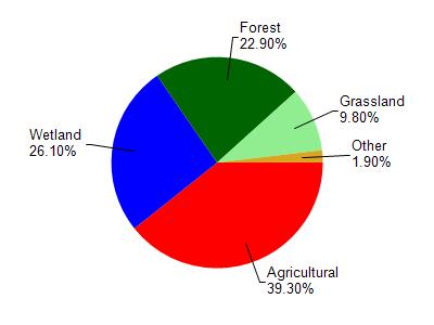
Bear Creek is located in the North Branch and Mainstem Embarrass Rive watershed which is 312.62 mi². Land use in the watershed is primarily agricultural (39.30%), wetland (26.10%) and a mix of forest (22.90%) and other uses (11.70%). This watershed has 488.32 stream miles, 1,175.84 lake acres and 51,339.03 wetland acres.
Nonpoint Source Characteristics
This watershed is ranked High for runoff impacts on streams, High for runoff impacts on lakes and High for runoff impacts on groundwater and therefore has an overall rank of High. This value can be used in ranking the watershed or individual waterbodies for grant funding under state and county programs.However, all waters are affected by diffuse pollutant sources regardless of initial water quality. Applications for specific runoff projects under state or county grant programs may be pursued. For more information, go to surface water program grants.
Bear Creek is considered a Warm Headwater, COOL-Warm Headwater under the state's Natural Community Determinations.
Natural communities (stream and lake natural communities) represent model results and DNR staff valiation processes that confirm or update predicted conditions based on flow and temperature modeling from historic and current landscape features and related variables. Predicated flow and temperatures for waters are associated predicated fish assemblages (communities). Biologists evaluate the model results against current survey data to determine if the modeled results are corect and whether biological indicators show water quaity degradation. This analysis is a core component of the state's resource management framework. Wisconsin's Riverine Natural Communities.
Cool (Warm-Transition) Headwaters are small, sometimes intermittent streams with cool to warm summer temperatures. Coldwater fishes are uncommon to absent, transitional fishes are abundant to common, and warm water fishes are common to uncommon. Headwater species are abundant to common, mainstem species are common to absent, and river species are absent.
Warm Headwaters are small, usually intermittent streams with warm summer temperatures. Coldwater fishes are absent, transitional fishes are common to uncommon, and warm water fishes are abundant to common. Headwater species are abundant to common, mainstem species are common to absent, and
river species are absent.