")
3 Miles
0 - 3
Cool-Cold Headwater, Cool-Warm Headwater
2025
Poor
Degraded Biological Community, Low DO, Degraded Habitat
Total Phosphorus, Sediment/Total Suspended Solids
Brown
No
No
Yes
Fish and Aquatic Life
Overview
Bower Creek, a 13-mile creek, supports a warm water forage fishery and a warm water sport fishery. This stream is a turbid hardwater stream draining sluggishly into the East River. The stream drains highly agriculturalized land where it picks up the heavy silt load that composes the bottom material. Undercut banks and rock provide instream cover. Crayfish are very prolific in this stream. The fishery consist of bluegills, young-of-the-year northern pike, suckers and carp. Stream habitat assessment surveys indicate poor to fair habitat and macroinvertebrate studies indicate poor to fair water quality. The highly agriculturalized watershed makes very poor recreational waters out of this stream. The Water Resources Division of the U.S. Geological Survey, in cooperation with local, State and Federal agencies, obtains a large amount of data pertaining to the water resources of Wisconsin each year (Holmstrom 1996). A gaging station is located on Bower Creek on the left bank downstream from the County Trunk Highway MM bridge, 1.1 mile east from intersection of Highways G and MM, and 6.2 miles southeast of the post office in De Pere (USGS 1996). Discharge data has been collected since October 1990. Please refer to the U.S. Geological Survey Water Resource Data Wisconsin Water Year 1996 for specific data. Funding should be secured to continue operating this U.S. Geological Survey gauging station to maintain adequate flow records in the Lake Michigan Geological Management Unit (GMU). Data will be used to monitor impacts from land practices in the Bower Creek Subwatershed. The basin was studied during 1985-86 to determine water quality in relation to stream flow. Data for Upper Bower Creek included baseline sample and event analysis. In a report by Hughes (1988) Upper Bower Creek had the highest mean concentrations of BOD-5, total phosphorus, fecal coliform and fecal streptoccoccus of all the sites monitored during 1985-86. This stream exceeded the acceptable coliform level for recreational water quality of 200 counts/100 ml 91% of the time. Agricultural discharges were suspected of contributing significantly to degraded water quality. Suspended solids at the downstream boundary of the Upper Bower Creek watershed was 264 tons/mi2/year. Total phosphorus yields were 2,676 lbs/mi2/yr (Hughes 1988).
Bougie, Cheryl A. 1999. Lower Fox River Basin Water Quality Management Plan. Public Review Draft. Wisconsin Department of Natural Resources, Madison, WI.
Date 1999
Author Cheryl Bougie
Impaired Waters
Bower Creek is on the state's 303(d) impaired waters list for Total Phosphorus and Total Suspended Solids since 2008.
This water was assessed during the 2012 listing cycle, and total phosphorus sample data exceed 2012 WisCALM listing criteria for the fish and aquatic life use, and biological impairment was observed (i.e. at least one macroinvertebrate or fish Index of Biotic Integrity (IBI) scored in the "poor" condition category). This water is part of the Lower Fox River TMDL that was approved by the EPA in 2012.
This water was assessed during the 2014 listing cycle; total phosphorus sample data overwhelmingly exceed 2014 WisCALM listing criteria for the Fish and Aquatic Life use and biological impairment was observed (i.e. at least one macroinvertebrate or fish Index of Biotic Integrity (IBI) scored in the poor condition category).
This water was assessed during the 2016 listing cycle; total phosphorus sample data overwhelmingly exceed 2016 WisCALM listing criteria for the Fish and Aquatic Life use and biological impairment was observed (i.e. at least one macroinvertebrate or fish Index of Biotic Integrity (IBI) scored in the poor condition category).
This water was assessed during the 2018 listing cycle; new total phosphorus sample data overwhelmingly exceeded the 2018 WisCALM listing criteria for the Fish and Aquatic Life use. Available biological data did not indicate impairment (i.e. no macroinvertebrate or fish Index of Biotic Integrity (IBI) scored in the "poor" condition category).
Date 2017
Author Ashley Beranek
Condition
Wisconsin has over 84,000 miles of streams, 15,000 lakes and milllions of acres of wetlands. Assessing the condition of this vast amount of water is challenging. The state's water monitoring program uses a media-based, cross-program approach to analyze water condition. An updated monitoring strategy (2015-2020) is now available. Compliance with Clean Water Act fishable, swimmable standards are located in the Executive Summary of Water Condition in 2018. See also the 'monitoring and projects' tab.
Reports
Recommendations
Navigability Determination
; Bower Creek;
Navigability Determination
NW SW S22 T22N R21E; Bowers Creek; Extended determination to receiving water
TMDL (USEPA) Approved
Bower Creek TMDL Approved
Monitor Water Quality or Sediment
DNR and partners should secure funds to continue operating the U.S. Geological Survey flow gaging station on Bower Creek at CTH MM.
Management Goals
Wisconsin's Water Quality Standards provide qualitative and quantitative goals for waters that are protective of Fishable, Swimmable conditions [Learn more]. Waters that do not meet water quality standards are considered impaired and restoration actions are planned and carried out until the water is once again fishable and swimmable
Management goals can include creation or implementation of a Total Maximum Daily Load analysis, a Nine Key Element Plan, or other restoration work, education and outreach and more. If specific recommendations exist for this water, they will be displayed below online.
Monitoring
Monitoring the condition of a river, stream, or lake includes gathering physical, chemical, biological, and habitat data. Comprehensive studies often gather all these parameters in great detail, while lighter assessment events will involve sampling physical, chemical and biological data such as macroinvertebrates. Aquatic macroinvertebrates and fish communities integrate watershed or catchment condition, providing great insight into overall ecosystem health. Chemical and habitat parameters tell researchers more about human induced problems including contaminated runoff, point source dischargers, or habitat issues that foster or limit the potential of aquatic communities to thrive in a given area. Wisconsin's Water Monitoring Strategy was recenty updated.
Grants and Management Projects
Monitoring Projects
| WBIC | Official Waterbody Name | Station ID | Station Name | Earliest Fieldwork Date | Latest Fieldwork Date | View Station | View Data |
|---|
| 118400 | Bower Creek | 053497 | Bower Creek - Bower At Hwy V | 5/1/1991 | 10/2/2002 | Map | Data |
| 118400 | Bower Creek | 10009445 | Bower Creek (1) 50m Upstream Of Hwy Gv | 5/31/1992 | 10/26/2025 | Map | Data |
| 118400 | Bower Creek | 10044380 | Bower Creek-Cty GV | 4/1/2015 | 4/16/2015 | Map | Data |
| 118400 | Bower Creek | 10044352 | Bower Creek-Bower Creek Rd. | 1/1/2015 | 7/6/2016 | Map | Data |
| 118400 | Bower Creek | 10040706 | Bower Creek 315m ds CTH GV | 7/2/2013 | 10/10/2016 | Map | Data |
|
Watershed Characteristics
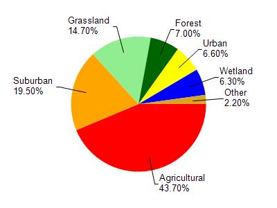
Bower Creek is located in the East River watershed which is 206.32 mi². Land use in the watershed is primarily agricultural (43.70%), suburban (19.50%) and a mix of grassland (14.70%) and other uses (22.10%). This watershed has 432.18 stream miles, 7,625.39 lake acres and 6,193.00 wetland acres.
Nonpoint Source Characteristics
This watershed is ranked High for runoff impacts on streams, Not Available for runoff impacts on lakes and High for runoff impacts on groundwater and therefore has an overall rank of High. This value can be used in ranking the watershed or individual waterbodies for grant funding under state and county programs.However, all waters are affected by diffuse pollutant sources regardless of initial water quality. Applications for specific runoff projects under state or county grant programs may be pursued. For more information, go to surface water program grants.
Bower Creek is considered a Cool-Cold Headwater, Cool-Warm Headwater under the state's Natural Community Determinations.
Natural communities (stream and lake natural communities) represent model results and DNR staff valiation processes that confirm or update predicted conditions based on flow and temperature modeling from historic and current landscape features and related variables. Predicated flow and temperatures for waters are associated predicated fish assemblages (communities). Biologists evaluate the model results against current survey data to determine if the modeled results are corect and whether biological indicators show water quaity degradation. This analysis is a core component of the state's resource management framework. Wisconsin's Riverine Natural Communities.
Cool (Warm-Transition) Headwaters are small, sometimes intermittent streams with cool to warm summer temperatures. Coldwater fishes are uncommon to absent, transitional fishes are abundant to common, and warm water fishes are common to uncommon. Headwater species are abundant to common, mainstem species are common to absent, and river species are absent.
Cool (Cold-Transition) Headwaters are small, usually perennial streams with cold to cool summer temperatures. Coldwater fishes are common to uncommon (<10 per 100 m), transitional fishes are abundant to common, and warm water fishes are uncommon to absent. Headwater species are abundant to common, mainstem species are common to absent, and river species are absent.