Fond Du Lac
No
No
No
Fish and Aquatic Life
Overview
WOLF LAKE
T16N, R19E, Sections 10, 15, Fond Du Lac County, Sheboygan River Watershed
Surface Acres = 77.0, S.D.F. = 1.76, Maximum Depth = 47 feet
This is a relatively small lake, but is heavily used for swimming, boating, and fishing, due to its good water quality and the scarcity of other lakes nearby. The water remains clear throughout the year and aquatic vegetation is found in a relatively narrow band along shore. A small stream from Giltner's Lake is intermittently draining to Wilke Lake. Water quality is good and excessive aquatic plants or algae are not a problem, although agricultural ditching and wetland drainage in the sub-watershed are threats. Lake levels have fluctuated, causing use problems, but the recent construction of a control levee at the outlet has improved the condition. Direct drainage from lawn areas and groundwater impacts from septic systems may be nutrient threats.
The lake contains a good fish population, with walleye, northern pike, largemouth bass, perch and bluegill in the fishery. Carp are present in the lake, but are not expected to interfere with present management. There is a county owned public use area which offers good swimming, boat rental, picnic area, and public boat launching, which was partly developed under the state cost sharing program for public access.
This is a 77-acre seepage/drainage lake with a maximum depth of 47 feet. Swimming, fishing and boating are common. Walleye, perch, bluegill and largemouth bass provide a good fishery. Wildlife uses are moderate as the shore zone is largely developed and contiguous wetlands are minimal.
Additional information on Wolf Lake is available within U.S. Geographical Survey lake monitoring reports, self-help program data and the Sheboygan River Priority Watershed Resource Appraisal Report (WDNR 1993). Recommendations have been developed for Wolf Lake, and are summarized in the Nonpoint Source Control Plan for the Sheboygan River Priority Watershed Project.
Aquatic Plants
A survey of aquatic plants was conducted on Wolf Lake. Table 45 lists the species observed during the survey. The lake appeared to be evenly populated with a mixture of Brittle Naiad (Najas marina), Eel Grass (Valisneria americana), Sago Pondweed (Potamogeton pectinatus), and an unidentified pondweed (Potamogeton sp.)
Table 35. List of aquatic plants found in Wolf Lake, Manitowoc County
Common Name
Scientific Name
Water Lily (Unidentified)
Yellow Water Lily
White Water Lily
Eel Grass
Eurasian Watermilfoil
Watermilfoil (native)
Brittle Naiad
Richardson Pondweed
Curly Leaf Pondweed
Narrow Leaf Pondweed
Unidentified Pondweed
Bulrush
Musk grass
Naiad (unidentified)
Sago Pondweed
Coontail
Nuphar sp.
Nymphaea sp.
Valisneria americana
Myriophyllum spicatum
Myriophyllum sp.
Najas marina
Potamogeton richardsonii
Potamogeton crispus
Potamogeton sp.
Potamogeton sp.
Juncus sp.
Chara sp.
Najas sp.
Potamogeton pectinatus
Ceratophyllum demersum
Water Quality
The water quality of Wolf Lake was sampled on May 12, and September 13, 1994. On May 12, the lake was slightly stratified with a 5-degree stratification factor and a dissolved oxygen profile, which resembled the beginning of a typical clinograde profile. In September, the lake was well stratified with a 12.9-degree stratification factor: the thermocline was located between 20 and 30 feet, and the dissolved oxygen was 0.1 ppm at 25 feet and 0.0 ppm to the bottom. The secchi depth was 6.1 and 3.0 meters in May and September respectively (Wakeman 1996). The water clarity data collected by the Self-Help Volunteer is summarized in Figure 16. The spring and fall water clarity measurements in 1994 are similar to those collected by the volunteer.
Date 2001
Author Aquatic Biologist
Overview
Trophic Status Index
The Trophic Status Index for Wolf Lake was calculated based upon the existing water quality information. Based upon the seven years of water quality information Wolf Lake can be classified as Mesotrophic (Figure 17).
Date 2001
Author Aquatic Biologist
Historical Description
Source: 1969, Surface Water Resources of Fond du Lac County
Wolf Lake, T16N, R19E, Sections 10, 15
Surface Acres = 77.0, S.D.F. = 1.76, Maximum Depth = 47 feet
This is a relatively small lake, but is heavily used for
swimming, boating, and fishing, due to its high quality water and
the fact that there are no other lakes nearby. The water remains
clear throughout relatively narrow band along shore. The inlet
originates at Giltner's Lake, a small winterkill lake, and the
outlet flows into the Sheboygan River.
The lake contains a good fish population, with walleye,
northern pike, largemouth bass and panfish in the fishery. Carp
are present in the lake, but are not expected to interfere with
present management.
There is a county-owned public use area which offers good
swimming, boat rental, picnic area, and public boat launching,
which was partly developed under the state cost-sharing program
for public access.
Date 1969
Author Surface Water Inventory Of Wisconsin
Management Goals
Wisconsin's Water Quality Standards provide qualitative and quantitative goals for waters that are protective of Fishable, Swimmable conditions [Learn more]. Waters that do not meet water quality standards are considered impaired and restoration actions are planned and carried out until the water is once again fishable and swimmable
Management goals can include creation or implementation of a Total Maximum Daily Load analysis, a Nine Key Element Plan, or other restoration work, education and outreach and more. If specific recommendations exist for this water, they will be displayed below online.
Monitoring
Monitoring the condition of a river, stream, or lake includes gathering physical, chemical, biological, and habitat data. Comprehensive studies often gather all these parameters in great detail, while lighter assessment events will involve sampling physical, chemical and biological data such as macroinvertebrates. Aquatic macroinvertebrates and fish communities integrate watershed or catchment condition, providing great insight into overall ecosystem health. Chemical and habitat parameters tell researchers more about human induced problems including contaminated runoff, point source dischargers, or habitat issues that foster or limit the potential of aquatic communities to thrive in a given area. Wisconsin's Water Monitoring Strategy was recenty updated.
Grants and Management Projects
Monitoring Projects
| WBIC | Official Waterbody Name | Station ID | Station Name | Earliest Fieldwork Date | Latest Fieldwork Date | View Station | View Data |
|---|
| 60800 | Wolf Lake | 10014824 | Wolf Lake | | | Map | Data |
| 60800 | Wolf Lake | 10041936 | Wolf3_East(HerbicideMonitoring) | 6/5/2014 | 7/18/2014 | Map | Data |
| 60800 | Wolf Lake | 10041935 | Wolf2_North(HerbicideMonitoring) | 6/5/2014 | 7/18/2014 | Map | Data |
| 60800 | Wolf Lake | 10041937 | Wolf4_South(HerbicideMonitoring) | 6/5/2014 | 7/18/2014 | Map | Data |
| 60800 | Wolf Lake | 10002487 | Wolf Lake | 6/9/1994 | 9/22/2017 | Map | Data |
| 60800 | Wolf Lake | 203058 | Wolf Lake - Deep Hole | 6/30/1987 | 6/16/2026 | Map | Data |
| 60800 | Wolf Lake | 10041934 | Wolf1_Deep(HerbicideMonitoring) | 6/5/2014 | 7/18/2014 | Map | Data |
| 60800 | Wolf Lake | 10019259 | Wolf Lake -- Access at S End Lake Nr Sth 149 | 7/5/2012 | 12/2/2024 | Map | Data |
| 60800 | Wolf Lake | 10038263 | Wolf Lake Beach | 6/2/2003 | 8/25/2025 | Map | Data |
|
Watershed Characteristics
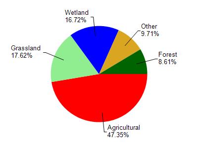
Wolf Lake is located in the Sheboygan River watershed which is 260.12 mi². Land use in the watershed is primarily agricultural (47.30%), grassland (17.60%) and a mix of wetland (16.70%) and other uses (18.30%). This watershed has 340.24 stream miles, 4,345.33 lake acres and 27,968.05 wetland acres.
Nonpoint Source Characteristics
This watershed is ranked Not Available for runoff impacts on streams, Not Available for runoff impacts on lakes and High for runoff impacts on groundwater and therefore has an overall rank of High. This value can be used in ranking the watershed or individual waterbodies for grant funding under state and county programs.However, all waters are affected by diffuse pollutant sources regardless of initial water quality. Applications for specific runoff projects under state or county grant programs may be pursued. For more information, go to surface water program grants.