Waukesha
No
No
No
Fish and Aquatic Life
Overview
Beaver Lake is a medium sized (316 acres), seepage fed lake in the kettle moraine. This lake has two basins of similar size. The outlet is impounded by a lowhead structure and flows intermittently to Pine Lake. The water is clear over a sand and marl bottom. WDNR has developed a walk-in access site on the southwest shoreline. The fishery consists of largemouth bass, northern pike and pan fish, notably yellow perch and bluegills. One boat livery provides a small amount of transient angler opportunity. The lake was treated for nuisance plant growth in 1958, but weeds are not considered a use problem. The lake is bordered by very irregular terrain, enhancing the aesthetic value of this waterbody. Waterfowl hunting is somewhat restricted due to extensive shore development of year round homes.
The Beaver Lake Yacht Club and Beaver Lake Environmental Protection Association are active on the lake, according to WDNR's 1994-95 Lake List. No lake management grants have been awarded to Beaver Lake and no volunteers are currently participating in the WDNR Self-Help Monitoring program.
Date 2002
Author Aquatic Biologist
Historical Description
Source: 1963, Surface Water Resources of Waukesha County Beaver Lake T8N, R18E, Sections 27 and 28 Surface Acres = 316, S.D.F. = 1.45, Maximum Depth = 49 feet.
A medium-sized, seepage-fed lake in the kettle moraine. This lake has two basins of nearly equal size. The outlet is impounded by a low head structure and flows intermittently to Pine Lake. The water is clear over a sand and marl bottom. A state highway provides access without nearby parking. It is not considered as suitable for public use. The fishery consists of largemouth bass, northern pike, and pan fish, notably yellow perch and bluegills. One boat livery provides a small amount of transient angler opportunity. The lake was treated for weed control in 1958, but weeds are not considered as a use problem. The lake is bordered by land of very irregular terrain, enhancing the aesthetic value of dds body of water. Waterfowl hunting is somewhat restricted due to extensive shore development for year-round homes.
Date 1963
Author Surface Water Inventory Of Wisconsin
General Condition
Beaver Lake (WBIC 774400) was assessed during the 2018 listing cycle; new chloride sample data were clearly below the 2018 WisCALM listing thresholds for Fish and Aquatic Life use. This water was meeting this designated use and was not considered impaired.
Date 2017
Author Ashley Beranek
Condition
Wisconsin has over 84,000 miles of streams, 15,000 lakes and milllions of acres of wetlands. Assessing the condition of this vast amount of water is challenging. The state's water monitoring program uses a media-based, cross-program approach to analyze water condition. An updated monitoring strategy (2015-2020) is now available. Compliance with Clean Water Act fishable, swimmable standards are located in the Executive Summary of Water Condition in 2018. See also the 'monitoring and projects' tab.
Reports
Management Goals
Wisconsin's Water Quality Standards provide qualitative and quantitative goals for waters that are protective of Fishable, Swimmable conditions [Learn more]. Waters that do not meet water quality standards are considered impaired and restoration actions are planned and carried out until the water is once again fishable and swimmable
Management goals can include creation or implementation of a Total Maximum Daily Load analysis, a Nine Key Element Plan, or other restoration work, education and outreach and more. If specific recommendations exist for this water, they will be displayed below online.
Monitoring
Monitoring the condition of a river, stream, or lake includes gathering physical, chemical, biological, and habitat data. Comprehensive studies often gather all these parameters in great detail, while lighter assessment events will involve sampling physical, chemical and biological data such as macroinvertebrates. Aquatic macroinvertebrates and fish communities integrate watershed or catchment condition, providing great insight into overall ecosystem health. Chemical and habitat parameters tell researchers more about human induced problems including contaminated runoff, point source dischargers, or habitat issues that foster or limit the potential of aquatic communities to thrive in a given area. Wisconsin's Water Monitoring Strategy was recenty updated.
Grants and Management Projects
Monitoring Projects
| WBIC | Official Waterbody Name | Station ID | Station Name | Earliest Fieldwork Date | Latest Fieldwork Date | View Station | View Data |
|---|
| 774400 | Beaver Lake | 10007201 | Beaver Lake | 6/1/1995 | 9/30/2017 | Map | Data |
| 774400 | Beaver Lake | 683120 | Beaver Lake - Deep Hole | 9/19/1973 | 4/14/2026 | Map | Data |
| 774400 | Beaver Lake | 10017493 | Beaver Lake -- Access at State Hwy 83 | 5/31/2014 | 7/24/2024 | Map | Data |
|
Watershed Characteristics
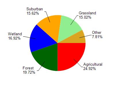
Beaver Lake is located in the Oconomowoc River watershed which is 130.86 mi². Land use in the watershed is primarily agricultural (24.90%), forest (19.70%) and a mix of wetland (16.90%) and other uses (38.40%). This watershed has 136.99 stream miles, 2,858.66 lake acres and 11,105.19 wetland acres.
Nonpoint Source Characteristics
This watershed is ranked Not Available for runoff impacts on streams, Not Available for runoff impacts on lakes and High for runoff impacts on groundwater and therefore has an overall rank of High. This value can be used in ranking the watershed or individual waterbodies for grant funding under state and county programs.However, all waters are affected by diffuse pollutant sources regardless of initial water quality. Applications for specific runoff projects under state or county grant programs may be pursued. For more information, go to surface water program grants.