Waukesha
No
No
No
Fish and Aquatic Life
Overview
Ashippun Lake is a deep (40 feet) 84-acres lake in Waukesha County. A deep water wetland lies on the west end of the lake, adjacent to its outlet. Ashippun Lake is known for its Northern Pike and panfisheries. Some walleye stocking was done in the 1980s. The lake is very popular for ice fishing. Public access is through a county park located on the south shore of the lake.
Date 2002
Author Aquatic Biologist
Historical Description
Source: 1963, Surface Water Resources of Waukesha County Ashippun Lake T8N, R17E, Section 15
A small spring-fed natural lake having two basins and an outlet to the Ashippun River. There are no permanent inlets. The lake has clear water over a sand, gravel, and marl bottom. The fishery is primarily pan fish, northern pike, and largemouth bass. Weeds are a major-use problem along developed shore and in the shallow west basin which constitutes about one-fifth of the lake area. One commercial facility rents boats for anglers. The valley of the Ashippun River adjoining the west end of the lake is lined with wetlands and waterfowl make limited migrant and resident use of the lake environs. The Conservation Department recently purchased access lands on this lake providing 1,600 feet of public frontage.
Surface Acres = 84, S.D.F. = 1.71, Maximum Depth = 40 feet
Date 1963
Author Surface Water Inventory Of Wisconsin
General Condition
Ashippun Lake (854300) was assessed during the 2016 listing cycle; total phosphorus and chlorophyll sample data were clearly below 2016 WisCALM listing thresholds for the Recreation use and Fish and Aquatic Life use. This water is meeting these designated uses and is not considered impaired.
Date 2015
Author Ashley Beranek
Condition
Wisconsin has over 84,000 miles of streams, 15,000 lakes and milllions of acres of wetlands. Assessing the condition of this vast amount of water is challenging. The state's water monitoring program uses a media-based, cross-program approach to analyze water condition. An updated monitoring strategy (2015-2020) is now available. Compliance with Clean Water Act fishable, swimmable standards are located in the Executive Summary of Water Condition in 2018. See also the 'monitoring and projects' tab.
Reports
Management Goals
Wisconsin's Water Quality Standards provide qualitative and quantitative goals for waters that are protective of Fishable, Swimmable conditions [Learn more]. Waters that do not meet water quality standards are considered impaired and restoration actions are planned and carried out until the water is once again fishable and swimmable
Management goals can include creation or implementation of a Total Maximum Daily Load analysis, a Nine Key Element Plan, or other restoration work, education and outreach and more. If specific recommendations exist for this water, they will be displayed below online.
Monitoring
Monitoring the condition of a river, stream, or lake includes gathering physical, chemical, biological, and habitat data. Comprehensive studies often gather all these parameters in great detail, while lighter assessment events will involve sampling physical, chemical and biological data such as macroinvertebrates. Aquatic macroinvertebrates and fish communities integrate watershed or catchment condition, providing great insight into overall ecosystem health. Chemical and habitat parameters tell researchers more about human induced problems including contaminated runoff, point source dischargers, or habitat issues that foster or limit the potential of aquatic communities to thrive in a given area. Wisconsin's Water Monitoring Strategy was recenty updated.
Grants and Management Projects
Monitoring Projects
| WBIC | Official Waterbody Name | Station ID | Station Name | Earliest Fieldwork Date | Latest Fieldwork Date | View Station | View Data |
|---|
| 854300 | Ashippun Lake | 10007261 | Unnamed Lake (T8 R17E S15) | 8/1/1977 | 7/9/2025 | Map | Data |
| 854300 | Ashippun Lake | 10017540 | Ashippun Lake -- Access | 7/22/2007 | 8/15/2025 | Map | Data |
| 854300 | Ashippun Lake | 683297 | Ashippun Lake - Deep Hole | 2/18/1981 | 6/20/2026 | Map | Data |
|
Watershed Characteristics
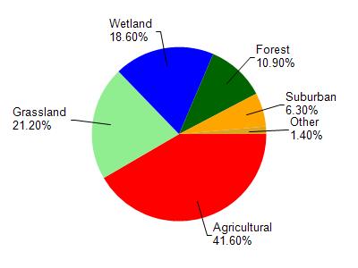
Ashippun Lake is located in the Ashippun River watershed which is 68.70 mi². Land use in the watershed is primarily agricultural (41.60%), grassland (21.20%) and a mix of wetland (18.60%) and other uses (18.60%). This watershed has 108.43 stream miles, 327.41 lake acres and 7,663.77 wetland acres.
Nonpoint Source Characteristics
This watershed is ranked Not Ranked for runoff impacts on streams, Not Ranked for runoff impacts on lakes and High for runoff impacts on groundwater and therefore has an overall rank of High. This value can be used in ranking the watershed or individual waterbodies for grant funding under state and county programs.However, all waters are affected by diffuse pollutant sources regardless of initial water quality. Applications for specific runoff projects under state or county grant programs may be pursued. For more information, go to surface water program grants.