Sauk
No
No
No
Fish and Aquatic Life
Overview
The 210-acre Dutch Hollow Lake, located in Sauk County, was created by impounding Dutch
Hollow Creek in the early 1970�s for real estate interests. The lake has a maximum depth of
40 feet, although the lake�s basin leaks and the community relies on groundwater pumping to
maintain the water level in the lake. The lake used to be a long term trends monitoring lake
and was monitored every five years. With the cessation of that program, the lake became a
baseline trends monitored lake. Now the lake�s
The fishery is comprised of largemouth bass, northern pike, stocked walleye, with bluegill,
black crappie, pumpkinseed and yellow perch representing panfish species. White suckers
and black bullhead are also present. The lake is noted for especially large size bluegill and
crappie. State records of both species were caught during 1994. A mercury consumption
advisory exists on walleye and bass. Eurasian water milfoil can be found in the lake.
Date 2002
Author Aquatic Biologist
Overview
Dutch Hollow Creek
The creek flows north to enter into the Wisconsin River just west of Millville. The creek is spring-fed and supports smaller forage fish species. There is access to the creek from the Millville Recreation Area.
Date 2001
Author Aquatic Biologist
Historical Description
Source: 1971, Surface Water Resources of Sauk County Dutch Hollow Lake, T13N R3E, Sec. 18
A drainage lake to be created by a dam with a 42-foot head that was under construction when this survey was completed in October 1970. It is located three miles northwest of LaValle. The lake is being built by a private Chicago agency and heavy development is expected along the shores. The watershed of the lake totals 5.07 square miles of which 80 percent has been cleared for agricultural purposes. The lake is expected to be very similar to Lake Redstone, in respect to heavy siltation in the upper reaches, algae problems, and extensive shore development. The major fishery will consist of northern pike, largemouth bass and panfish. Pleasure boating is expected to be a popular activity on the lake. Game assets that inhabit theuplands at the present time include deer, raccoon, squirrels, rabbits, fox, and ruffed grouse. A few migrating puddle ducks will very likely frequent the lake. Public access is to be provided at two sites upon completion of the lake.
Surface area = 210 acres, S.D.F. = 2.31, Maximum depth = 40 feet.
Date 1971
Author Surface Water Inventory Of Wisconsin
General Condition
Dutch Hollow Lake (1286500) was assessed during the 2016 listing cycle; total phosphorus and chlorophyll sample data were clearly below 2016 WisCALM listing thresholds for the Recreation use and Fish and Aquatic Life use. This water is meeting these designated uses and is not considered impaired.
Date 2015
Author Ashley Beranek
Condition
Wisconsin has over 84,000 miles of streams, 15,000 lakes and milllions of acres of wetlands. Assessing the condition of this vast amount of water is challenging. The state's water monitoring program uses a media-based, cross-program approach to analyze water condition. An updated monitoring strategy (2015-2020) is now available. Compliance with Clean Water Act fishable, swimmable standards are located in the Executive Summary of Water Condition in 2018. See also the 'monitoring and projects' tab.
Reports
Management Goals
Wisconsin's Water Quality Standards provide qualitative and quantitative goals for waters that are protective of Fishable, Swimmable conditions [Learn more]. Waters that do not meet water quality standards are considered impaired and restoration actions are planned and carried out until the water is once again fishable and swimmable
Management goals can include creation or implementation of a Total Maximum Daily Load analysis, a Nine Key Element Plan, or other restoration work, education and outreach and more. If specific recommendations exist for this water, they will be displayed below online.
Monitoring
Monitoring the condition of a river, stream, or lake includes gathering physical, chemical, biological, and habitat data. Comprehensive studies often gather all these parameters in great detail, while lighter assessment events will involve sampling physical, chemical and biological data such as macroinvertebrates. Aquatic macroinvertebrates and fish communities integrate watershed or catchment condition, providing great insight into overall ecosystem health. Chemical and habitat parameters tell researchers more about human induced problems including contaminated runoff, point source dischargers, or habitat issues that foster or limit the potential of aquatic communities to thrive in a given area. Wisconsin's Water Monitoring Strategy was recenty updated.
Grants and Management Projects
Monitoring Projects
| WBIC | Official Waterbody Name | Station ID | Station Name | Earliest Fieldwork Date | Latest Fieldwork Date | View Station | View Data |
|---|
| 1286500 | Dutch Hollow Lake | 10048307 | Dutch Hollow Lake - Woodland Bay (Herbicide Monitoring) | 6/13/2017 | 6/9/2023 | Map | Data |
| 1286500 | Dutch Hollow Lake | 573195 | Dutch Hollow Lake - Dutch Hollow Lake | | | Map | Data |
| 1286500 | Dutch Hollow Lake | 10014914 | Dutch Hollow Lake | | | Map | Data |
| 1286500 | Dutch Hollow Lake | 10048309 | Dutch Hollow Lake - Summit Bay (Herbicide Monitoring) | 6/13/2017 | 7/12/2021 | Map | Data |
| 1286500 | Dutch Hollow Lake | 10048310 | Dutch Hollow Lake - Marina (Herbicide Monitoring) | 6/13/2017 | 7/12/2021 | Map | Data |
| 1286500 | Dutch Hollow Lake | 10057625 | Dutch Hollow - West Main Basin | 6/5/2023 | 6/9/2023 | Map | Data |
| 1286500 | Dutch Hollow Lake | 10005445 | Dutch Hollow Lake | 6/1/1988 | 7/31/2023 | Map | Data |
| 1286500 | Dutch Hollow Lake | 10056302 | Dutch Hollow Lake - II21 | 6/14/2022 | 6/18/2022 | Map | Data |
| 1286500 | Dutch Hollow Lake | 10056301 | Dutch Hollow Lake - GG21 | 6/14/2022 | 6/18/2022 | Map | Data |
| 1286500 | Dutch Hollow Lake | 10019406 | Dutch Hollow Lake -- Access off Dutch Hollow Road | 5/3/2006 | 8/23/2025 | Map | Data |
| 1286500 | Dutch Hollow Lake | 10048308 | Dutch Hollow Lake - Black Forest Bay (Herbicide Monitoring) | 6/13/2017 | 7/12/2021 | Map | Data |
| 1286500 | Dutch Hollow Lake | 573060 | Dutch Hollow Lake - Deep Hole | 7/1/1980 | 6/23/2026 | Map | Data |
|
Watershed Characteristics
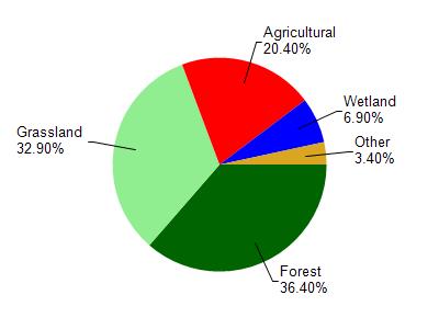
Dutch Hollow Lake is located in the Crossman Creek and Little Baraboo River watershed which is 213.80 mi². Land use in the watershed is primarily forest (36.40%), grassland (32.90%) and a mix of agricultural (20.40%) and other uses (10.30%). This watershed has 466.61 stream miles, 244.11 lake acres and 6,321.59 wetland acres.
Nonpoint Source Characteristics
This watershed is ranked Not Available for runoff impacts on streams, Not Available for runoff impacts on lakes and High for runoff impacts on groundwater and therefore has an overall rank of High. This value can be used in ranking the watershed or individual waterbodies for grant funding under state and county programs.However, all waters are affected by diffuse pollutant sources regardless of initial water quality. Applications for specific runoff projects under state or county grant programs may be pursued. For more information, go to surface water program grants.