Iowa
No
No
No
Fish and Aquatic Life
Overview
Pedler Branch is a tributary to Sudan Branch in Iowa County. Polluted runoff from barnyards and streambank grazing have degraded in-stream habitat and water (Schlesser, 1993). One permitted facility discharges to the stream. The facility had some problems, but these have been corrected. Recent monitoring resulted in a stream classification change, upgrading the limited forage fishery reach to warm water forage fishery. This represents an improvement in water quality (Schlesser, 1989). The wastewater treatment facility at Bloomfield Manor is being upgraded and this should further improve water quality of the stream. The slender madtom, a fish on the state's endangered species list has been found here (Fago, 1982).
Date
Author Aquatic Biologist
Overview
Pedler Branch is a tributary to Sudan Branch in Iowa County. It has a fairly steep gradien. The stream suffers degradation to habitat from polluted runoff. One permitted facility, Bloomfield Manor, discharges to the stream. Although this stream is classified as a warm water sport fishery for most of its length, the smallmouth bass population is fairly limited (Sims, 2001). The slender madtom, a fish on the state’s endangered species list, has been found here (Fago, 1982). However, Pedler Branch has not been monitored in recent years.
Date 2002
Author Aquatic Biologist
Historical Description
Pedler Creek (Spincely) - Mouth location T5N R2E Section 21 -8, Surface area = 6.1 acres, Length = 7.5 miles, Gradient = 42.3 feet per mile, Total alkalinity = 288.0 mg/l, Volume of flow = 1.4 cfs.
Pedler Creek begins at springs and ground seepage on the vale of the cuesta which is part of the Galena-Black River uplands and flows southwesterly as the principal tributary of the East Pecatonica River. There is a possible source of pollution at its headwaters in the effluent it receives from the sewage treatment of the Iowa County Hospital and Home which is closely checked by the Division of Environmental Protection. It has a fairly steep gradient and about 95 percent of its watershed area is cleared land devoted to crops and pasture. As a result, the runoff of precipitation is quite rapid which is evidenced by the records of sudden flooding and subsequent heavy bank erosion.
Electrofishing surveys show that it is a good smallmouth bass stream and catfish are present; especially in the lower sections. Panfishes present include green sunfish and pumpkinseed. Forage and rough fish include bluntnose and stoneroller minnows, creek and hornyhead chubs; white and hogsuckers; common shiners, johnny darters, northern redhorse and quillback.
There are five known farm ponds in the watershed which serve as erosion controls and support small populations of largemouth bass to supplement the stream fishery.
Aquatic game assets include wood ducks and green herons near the mouth. Muskrats are found throughout most of its length. There are no public lands on this stream but it can be reached from five road crossings.
From: Piening, Ronald and Threinen, C.W., 1968. Lake and Stream Classification Project. Surface Water Resources of Iowa County, Wisconsin Department of Natural Resources, Madison, WI.
Date 1968
Author Surface Water Inventory Of Wisconsin
Condition
Wisconsin has over 84,000 miles of streams, 15,000 lakes and milllions of acres of wetlands. Assessing the condition of this vast amount of water is challenging. The state's water monitoring program uses a media-based, cross-program approach to analyze water condition. An updated monitoring strategy (2015-2020) is now available. Compliance with Clean Water Act fishable, swimmable standards are located in the Executive Summary of Water Condition in 2018. See also the 'monitoring and projects' tab.
Reports
Management Goals
Wisconsin's Water Quality Standards provide qualitative and quantitative goals for waters that are protective of Fishable, Swimmable conditions [Learn more]. Waters that do not meet water quality standards are considered impaired and restoration actions are planned and carried out until the water is once again fishable and swimmable
Management goals can include creation or implementation of a Total Maximum Daily Load analysis, a Nine Key Element Plan, or other restoration work, education and outreach and more. If specific recommendations exist for this water, they will be displayed below online.
Monitoring
Monitoring the condition of a river, stream, or lake includes gathering physical, chemical, biological, and habitat data. Comprehensive studies often gather all these parameters in great detail, while lighter assessment events will involve sampling physical, chemical and biological data such as macroinvertebrates. Aquatic macroinvertebrates and fish communities integrate watershed or catchment condition, providing great insight into overall ecosystem health. Chemical and habitat parameters tell researchers more about human induced problems including contaminated runoff, point source dischargers, or habitat issues that foster or limit the potential of aquatic communities to thrive in a given area. Wisconsin's Water Monitoring Strategy was recenty updated.
Grants and Management Projects
| Project Name (Click for Details) | Year Started |
|---|
|
|
Monitoring Projects
| WBIC | Official Waterbody Name | Station ID | Station Name | Earliest Fieldwork Date | Latest Fieldwork Date | View Station | View Data |
|---|
| 929700 | Peddler Creek | 253023 | Linden Branch (Pedler Cr) at Sth 39 | 1/1/2015 | 10/6/2015 | Map | Data |
| 929700 | Peddler Creek | 253025 | Linden Branch (Pedler Cr) - Bl Linden Stp | 1/1/2015 | 1/1/2015 | Map | Data |
| 929700 | Peddler Creek | 10032522 | Peddler Creek at 0.6 miles E of Linden (private drive 2526 Wearne Rd) | 1/1/2015 | 10/6/2015 | Map | Data |
| 5037604 | Unnamed | 253031 | Peddler Creek - Below Jewell Mine | | | Map | Data |
|
Watershed Characteristics
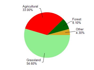
Peddler Creek is located in the Mineral Point and Sudan Branches watershed which is 108.26 mi². Land use in the watershed is primarily grassland (54.60%), agricultural (33%) and a mix of forest (8.10%) and other uses (4.30%). This watershed has 289.93 stream miles, 87.79 lake acres and 699.78 wetland acres.
Nonpoint Source Characteristics
This watershed is ranked Not Ranked for runoff impacts on streams, Not Ranked for runoff impacts on lakes and High for runoff impacts on groundwater and therefore has an overall rank of High. This value can be used in ranking the watershed or individual waterbodies for grant funding under state and county programs.However, all waters are affected by diffuse pollutant sources regardless of initial water quality. Applications for specific runoff projects under state or county grant programs may be pursued. For more information, go to surface water program grants.