Grant
No
No
No
Fish and Aquatic Life
Overview
Rountree Branch is a seepage and spring fed tributary to the Little Platte River just west of Platteville. The stream is considered a smallmouth bass nursery in its lower reaches. In the 1960's the stream was considered to have no fisheries value due pollution from various sources in and near Platteville (Smith and Ball, 1972). These sources included industrial and municipal point sources, abandoned mining waste piles, and urban and agricultural non-point sources of pollution. Water quality and instream habitat conditions have improved generally since then and the stream is capable of supporting at least a limited sport fishery (Fix, 1991). Recent evaluations by fisheries biologists have resulted in a recommendation to consider 6 miles of Rountree as a class II trout fishery (WDNR,2000).
While conditions have improved, there are still problems. The State Laboratory of Hygiene biomonitoring tests done in 1998 showed that water samples taken from Rountree were chronically toxic to Ceriodaphnia dubia, a small aquatic organism. Metals are the most likely source of the toxicity (Wisconsin State Laboratory of Hygiene, 1998). Elevated zinc levels in the water column have been detected in some monitoring done in 1996 at one location on the stream and recent monitoring has shown that the concentration of lead, zinc and copper increased dramatically during a large rainfall event (WDNR, 1998; Marshall 1999). In addition, urban non-point sources of pollution from Platteville and agricultural non-point sources are still a problem.
The City of Platteville’s wastewater treatment plant discharges to Rountree Branch. It is a generally well-run facility. GHC Evergreen Village, Inc. on the east edge of Platteville also has a permitted wastewater discharge to the stream. In 1999, a dairy processing operation requested water quality based limits be determined for a proposed discharge to Rountree.
A local group has been formed in Platteville to enhance Rountree Branch. The primary goals of this group are to establish a sport fishery in one reach of the stream and build a recreational trail along the stream. Overall, there are a variety of groups interested Rountree Branch. For a complete list of groups and their activities, see Volume 2.
Date 2001
Author Aquatic Biologist
Historical Description
A seepage- and spring-fed stream beginning near the Grant and Lafayette County line and flowing in an easterly direction through the City of Platteville to enter the central portions of the Little Platte River. This stream flows through a rather scenic valley in its lower reaches and Wisconsin State University-Plattevill is located on the north bank in the central portion. Rubble and a stratified limestone bedrock are the principal bottom types. This stream has no fishery value at the present time due to the fact that it has been heavily polluted. Very few forage fish are present and aquatic food organisms are scarce. Improperly treated effluent entering the stream from the Platteville Sewage Treatment Plant caused a large fish kill in 1970. Many crayfish were also killed. This pollution killed catfish and smallmouth bass in the Little Platte River. The stream has been heavily polluted for many years by many different sources. The sewage plant a dairy, the Platteville Water Department, and a trailer court in Lafayette County are considered potential sources of pollution at the present time. Efforts are being made by the Department of Natural Resources to stop this pollution in order to make this a productive stream once agaLn. Gam. assets are restricted to the upland varieties at the present time. Public access is available from five bridge crossings and 15 dwellings adjoin the stream.
From: Smith, Tom D., and Ball, Joseph R., Lake and Stream Classification Project. Surface Water Resources of Grant County, Department of Natural Resources, 1972. Surface Area = 17.46 acres, Length = 18.0 miles, Gradient 12 ft./mile, Flow = 5.4 c.f.s.
Date 1972
Author Aquatic Biologist
Historical Description
Roundtree Branch, T3N, R1E, Sections 18-6, Surface acres = 0.5, Miles = 0.8, Gradient = 50.0 feet per mile, Total alkalinity = 298 mg/l, Volume of flow = 0.5 cfs.
Roundtree Branch is one of the two streams in Lafayette County which is tributary to the Little Platte River. Although the watershed area within the county is not too significant, there is a considerable volume of flow. The principal bottom types are rubble and gravel. Most of the watershed is either in agricultural cropland or firm pasture. Although the stream gradient is high, bank erosion is light to moderate throughout its length within the county. Presently, it is managed for forage fish in Lafayette County. In Grant County it is managed for smallmouth bass. Game assets in the watershed are limited to pheasants, quail, squirrels, rabbits and deer. There are no public lands in the watershed. Public access is restricted to one town road bridge.
From: Piening, Ronald; Poff, Ronald; Threinen, C.W., 1967. Lake and Stream Classification Project. Surface Water Resources of Lafayette County, Wisconsin Department of Natural Resources, Madison, WI.
Date 1967
Author Surface Water Inventory Of Wisconsin
Recommendations
Watershed Mapping or Assessment
The Platteville Community Arboretum, Inc. will sponsor a restoration project of the Rountree Branch Watershed within the Platteville city limits and its tributaries. Project deliverables include: 1) Identify the brownfields affecting the northern tributaries and assess the potential removal of the waste sites. After an assessment, the PCA will apply for grants from the EPA Brownfields Program, 2) Prepare a plan to restore in-stream and floodplain habitat to promote native flora and fauna in the Keystone property. 3) Collaborate with the University of Wisconsin-Platteville engineering and reclamation programs to complete hydrology reports and develop an action plan to aid in the restoration of the main tributary, 4) Assess the capacity of the Southeast Tributary to support a native brook trout population, 5) facilitate education about natural resources at various levels. A report containing the findings of each of these items will be prepared and submitted to the DNR with the final report.
Watershed Mapping or Assessment
Platteville Community Arboretum, Inc., will sponsor a project involving the Rountree Branch watershed, Grant County. Project deliverables include: 1) identify five different restoration/demonstration sites that unite the efforts, resources, and interests of stakeholders and the Platteville community in the Rountree Branch watershed; 2) being the process of implementing a comprehensive management plan for the watershed; 3) explore methods of effective restoration efforts; 4) facilitate education about natural resources and restoration at various levels.
Monitor Watershed (Status,Sources,Impairments)
The primary goals and objectives of this project are to: 1) establish a collaborative organization of stakeholders that will work together on the management, recreation, conservation, restoration and understanding of the Roundtree Branch watershed; 2) develop a comprehensive management plan for the watershed; and 3) facilitate educational opportunities.
Monitor Targeted Area
The Friends of the Rountree will monitor water quality, assess physical and biological habitat, determine the need for stream channel improvements, assess water quality using bioassay testing, identify pollution sources and effective abatement practices, and develop cooperative agreements between stakeholders to create and implement a management plan for the rountree branch of the Little Platte River.
Monitor Fish Community
The DNR should monitor Blockhouse Creek, Little Platte River, and Mounds, Rountree and Young Branches to track the status of state endangered and threatened species and species of concern. Result: Done.
Monitor Targeted Area
The DNR, with the Wisconsin State Laboratory of Hygiene should conduct additional monitoring and investigation on Rountree Branch to determine if metals constitute a water quality problem, the extent and source(s) of any heavy metal pollution. Result: Assessed fishery in 2009. Final report Complete.
Fish Management, Access
The DNR in partnership with the Friends of Rountree Branch, Trout Unlimited, University of Wisconsin-Platteville, the Grant County Land Conservation Service and the U.S. NRCS should continue work on improving the cold water fishery on a reach of Rountree Branch at Platteville.
Monitor or Propose 303(d) Listing
Rountree Branch should be monitored and considered for addition to Wisconsins list of impaired streams due to degradation from non-point sources of pollution and problems with failure of WET toxicity tests. Fishery assessed in 2009. Final report forthcoming .
Management Goals
Wisconsin's Water Quality Standards provide qualitative and quantitative goals for waters that are protective of Fishable, Swimmable conditions [Learn more]. Waters that do not meet water quality standards are considered impaired and restoration actions are planned and carried out until the water is once again fishable and swimmable
Management goals can include creation or implementation of a Total Maximum Daily Load analysis, a Nine Key Element Plan, or other restoration work, education and outreach and more. If specific recommendations exist for this water, they will be displayed below online.
Monitoring
Monitoring the condition of a river, stream, or lake includes gathering physical, chemical, biological, and habitat data. Comprehensive studies often gather all these parameters in great detail, while lighter assessment events will involve sampling physical, chemical and biological data such as macroinvertebrates. Aquatic macroinvertebrates and fish communities integrate watershed or catchment condition, providing great insight into overall ecosystem health. Chemical and habitat parameters tell researchers more about human induced problems including contaminated runoff, point source dischargers, or habitat issues that foster or limit the potential of aquatic communities to thrive in a given area. Wisconsin's Water Monitoring Strategy was recenty updated.
Grants and Management Projects
Monitoring Projects
| WBIC | Official Waterbody Name | Station ID | Station Name | Earliest Fieldwork Date | Latest Fieldwork Date | View Station | View Data |
|---|
| 946000 | Rountree Br | 223245 | Rountree Branch - Southwest Rd. (Bi) | 5/10/1979 | 8/2/2003 | Map | Data |
| 946000 | Rountree Br | 223074 | Rountree Branch - Above Platteville Stp | | | Map | Data |
| 946000 | Rountree Br | 223272 | Rountree Branch at UW Platteville Park Rn03 | 7/10/2000 | 11/1/2018 | Map | Data |
| 946000 | Rountree Br | 10007998 | Rountree Br. Station 1 (Us Little Platte River) | 11/6/2000 | 11/6/2000 | Map | Data |
| 946000 | Rountree Br | 10014316 | Rountree Branch At Southwest Road | 7/14/1992 | 5/23/2022 | Map | Data |
| 946000 | Rountree Br | 10007999 | Rountree Br. Station 2 | | | Map | Data |
| 946000 | Rountree Br | 223076 | Rountree Branch - Off Grant Cth B | | | Map | Data |
| 946000 | Rountree Br | 223077 | Rountree Branch at Private Rd | | | Map | Data |
| 946000 | Rountree Br | 223048 | Rountree Branch - 500 Ft Bl Pltvl Stp | 7/14/1992 | 8/19/1992 | Map | Data |
|
Watershed Characteristics
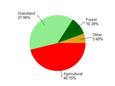
Rountree Br is located in the Little Platte River watershed which is 154.94 mi². Land use in the watershed is primarily agricultural (46.20%), grassland (38%) and a mix of forest (10.40%) and other uses (5.50%). This watershed has 389.19 stream miles, 19.99 lake acres and 585.06 wetland acres.
Nonpoint Source Characteristics
This watershed is ranked High for runoff impacts on streams, Not Available for runoff impacts on lakes and High for runoff impacts on groundwater and therefore has an overall rank of High. This value can be used in ranking the watershed or individual waterbodies for grant funding under state and county programs.However, all waters are affected by diffuse pollutant sources regardless of initial water quality. Applications for specific runoff projects under state or county grant programs may be pursued. For more information, go to surface water program grants.